
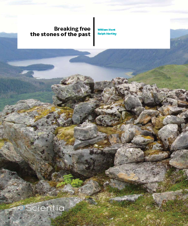
William Hunt Ralph Hartley – Breaking Free The Stones Of The Past
It’s difficult to remember, as we sit in our air-conditioned offices worrying about the latest report and the cost of today’s coffee, that most of human history has been spent in close contact with the soil, the trees, the rocks – with our ancestors struggling to improve their lives by changing the very landscape they stood upon. Many of these changes are still visible today, from the terraced slopes of hillside agriculture through to fields cleared of rocks for the plough. But the thinking behind many of our ancient modifications is lost in the mists of time – who made this, why did they do it, what were they thinking?
Nowhere is this better illustrated than in the existence of cairns, literally a man-made pile of rocks. The simplicity of the materials required (rocks are quite common, after all) combined with the ease of construction have led to cairns being a common sight throughout the world: they have been found in locations ranging from arctic Scandinavia to desert Africa, from the mountains of Mongolia through to the islands of Hawaii.
The cairns of the north
Cairns are particularly prevalent in the arctic North America, a region which covers Alaska, Canada and Greenland, to the point where an inuksuk features on the flag of the far-north Canadian territory of Nunavut. These structures played a number of roles, but could usually be divided into those used for orientation, hunting, storage, and remembrance.
Possibly the most common role played by cairns is that of orientation. In an environment where there are very few frees, bushes, or other landmarks, a rock cairn acts as an unmistakable marker – someone was here. Multiple cairns may point out a path stretching across the wilderness, a single cairn may show the location of a shoreline to help with seaborne navigation. Even today, cairns are often used as trail markers in mountainous regions or above the tree-line – in high-Alpine environments as in Arctic Tundra, these constructs stand out against the overwhelmingly ‘flat’ background. Cairns were also often used in hunting.
A hunting cairn could be a simple semicircular blind, behind which hunters could lie in wait for their chosen prey. It could also be part of a complex drive line, essentially a cairn which would look out-of-place to prey in a panic, helping to herd them in the direction of the hunters’ choosing. The meat obtained would then need to be stored and protected from any local scavengers, which is where the storage cairn comes into play. Constructed from local materials and large enough to attract attention when trying to find the food again, storage cairns are well documented constructs across the Arctic.
Rock cairns are well-known throughout the coastal regions of Canada and Alaska, having been constructed by the native inhabitants for all of the purposes described above. But historically, Native Americans in Southeast Alaska had lived along the coast gathering seafoods. Further, the rugged inland landscape had focused modern development along the coast. Together, history and development concentrated archaeologists’ attention on the coastline – leading to many more discoveries of many more sites of interest and thus making a self-perpetuating cycle of discovery. But there is more to the arctic than the coastline and the inland regions were also heavily utilised by native inhabitants – are cairns a feature of the inland alpine regions as well? And if so, why were they made?
‘The oldest cairn was there as Attila the Hun rampaged across Europe, the newest cairn was built when Da Vinci painted the Mona Lisa’
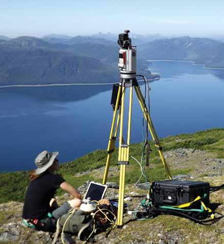
Marianne Okal mapping the Cross Peak survey area with TLS equipment
Signs of our forefathers
The story here starts with two elders of the Sitka Tlingit. The Tlingit have been a part of south-eastern Alaska for over 4000 years – living, hunting, loving, dying in an area which requires a keen eye for survival, ever ready to punish the unwary and unprepared. The annual cycle of activities needed to provide food and shelter act as a foundation of their customs and rituals, in turn providing the common culture holding the group together. The Tlingit call the rock cairns té xóow and generally consider them constructs made by their ancestors in the distant past.
The two elders had heard stories in their youth of cairns high on the peak of a mountain near their family’s summer fishing camp. Oral histories referred to them as representing monuments of the Great Flood, built by those who had survived the deluge, but they remained a mysterious presence. To determine the truth of the matter, they turned to a local National Park Service Superintendent and honorary tribal member for help.
Enter Professor William Hunt, who at the time was working as an Archaeologist at the National Park Service and who had recently concluded a 4-year study of Sitka archaeological sites. This background made him the perfect candidate to follow up on the request, and so he was quickly roped into the initial survey. As he recalls, the US Coast Guard flew ‘myself and three others (another archaeologist, an armed Ranger to protect us from brown bears, and historian to represent the park) to two different locations to get more information… the team was amazed to find not just one cairn at each location but nine cairns on one mountain ridge and twelve at the other.’
Why was this so amazing, we might ask? Until this point the common academic belief was that alpine cairns were rare and relatively unimportant – a belief supported by the lack of cairn site discoveries in alpine area. Suddenly, the common consensus seemed to be wrong. Alpine sites were all over the island, the academic field seemed to be ripe for a breakthrough. Hunt was infected with this excitement, ‘I couldn’t stop thinking about them. What were these things? Why were they built? Who built them and when? Why did they occur on the steep mountain sides and ridges above the tree line but within sight of the ocean?’
Exit right, pursued by a bear
To attempt to answer these questions, Professor William Hunt brought Professor Ralph Hartley into the picture. The two of them successfully obtained funding from the National Science Foundation to follow-up on these preliminary results. Up to this point, the existence of alpine cairns in the area was still quite the mystery – to scientists, to native inhabitants, to everyone. The goal of the project was to brush away some of this mystery, to systematically identify and investigate these cairns so as to find out who made them and when.
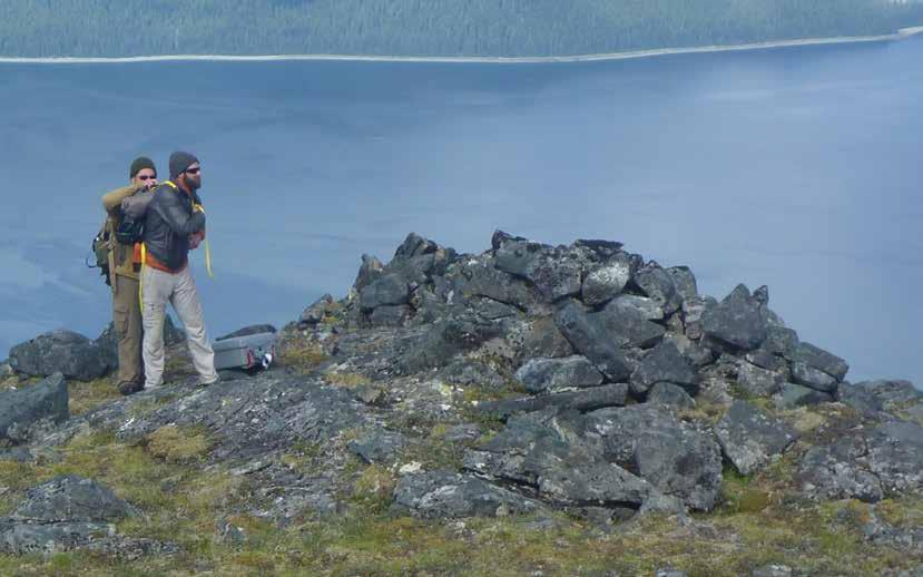
Sounds simple, doesn’t it? Well…no. First they had to deal with the location. Baranof Island lies within the Alexander Archipelago, a breathtakingly beautiful region which is perhaps best described a series of impenetrable, rugged mountains rising from the water. The zone receives so much rain that it is officially classed as a rainforest. Grizzly bears stalk the islands, hunting Sitka deer and unfortunate academics. Movement around the inland regions requires a helicopter, or long days of slow and difficult hiking.
Despite these difficulties the group was able set up camp on a mountain top and began to investigate the region. Their initial steps used LIDAR to survey and image the surrounding terrain down to an exceptional level of detail (LIDAR is essentially a laser which measures the distance from the emitter to the point the beam lands on – repeat this from enough locations and you have a 3D map of the area, mountains and cairns included). This treeless location was covered by ‘pedestrian survey’, an innocuous term for archaeologists’ exhausting hikes throughout the region, eyes always on the lookout for rock cairns or other historical indications. Within a few weeks, an astounding fifty cairns were discovered within about three-quarters of a square mile (about 2 square km). This on-the-ground survey was complemented a year later with a helicopter flights, thought of as a way to quickly locate potential cairns which could be properly assessed afterwards. It turned out to be an exceptionally useful technique, a mere three hours’ survey flight picking out almost 40 cairns across just under 30 sites.
Leaving no stone unturned
Following the initial survey, four large cairns were picked out for a detailed investigation. The archaeologists’ goals were to recover any artefacts which could assist in determining who built the cairns, and why, as well as to pull out any organic material which might help in detecting when the cairns were built. Though techniques varied, this process can be thought of as the extremely careful removal of each rock, piece by piece, searching through the entire cairn for information, before rebuilding the cairn exactly as it was. As you would expect, this process was only performed after consulting with the Sitka tribe, who consider these sites to be a sacred part of their history.
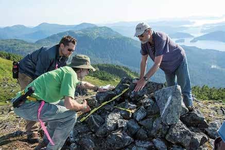
Ralph Hartley (left foreground), Michael Chodoronek (left background) and Bruce McCune (right) recording a cairn in the Cross Peak investigation area
One of the major questions at the start of the study was a simple: when? When were these cairns made? Despite a complete lack of written history or local artefacts, this question turns out to be answerable through the power of radiocarbon dating and the careful study of lichens growing on the cairns. For those unfamiliar with the technique, radiocarbon dating essentially involves the very careful measurement of carbon isotope levels to determine how long it has been since an organic object (e.g. shoes) was alive (e.g. as a cow). The technique has a certain degree of variability the accuracy tending to be lesser with objects from the more distant past. In this case, the lack of organic objects in the cairns forced the archaeologists to date the soils beneath the cairns. The resulting dates provided a ‘not earlier than’ date for when each tested cairn was built. Discovering the minimum age of a cairn or other surface through the study of lichens growing on a cairn depends on estimating the growth of certain lichens that grow radially – as a circle. A younger lichen patch will be smaller in diameter than a patch that is older. Lichenologists also used a new method of relatively dating cairns through observing and measuring ‘colonizing’ lichen and plant growths that succeed one another on a rock or on the cairn as a whole. ‘Relative dating’ tells us the sequence of cairn construction but does not provide a date for each cairn’s construction.
Their results? The earliest cairn was built sometime between AD 400–500; the latest between AD 1450–1600. To put this into context, the oldest cairn was there as Attila the Hun rampaged across Europe, the newest cairn was built when Da Vinci painted the Mona Lisa. The amount of history which has occurred between the constructions of these two cairns is the subject of a lifetime’s study, and yet there are many more still waiting in the coastal mountains of Baranof Island. How much more can be learned from these other cairns, mute observers of the Tlingit struggle to survive in the cold northern environment?
We asked Professor Hunt what the next steps in their research would be. ‘As far as future fieldwork and research goes,’ he commented, ‘we have considered doing drone or helicopter inventories of mountains, both inland and coastal, to determine the distributions of alpine cairns across the landscapes of Southeast Alaska. We have also put some thought into looking at similar regions in the world to see if cairns would occur in the same kinds of alpine environments – areas such as southern Chile and Argentina or Norway.’ The difficulty of traversing the inland regions practically requires an aerial survey, and only with a solid grasp of the numbers of rock cairns present can the researchers determine where to focus their sadly limited time. Both William Hunt and Ralph Hartley are currently Adjunct Professors in the Dept. of Anthropology at the University of Nebraska- Lincoln, roles which have brought them full circle back to their original alma mater (albeit quite a few years later). Not content with turning conventional beliefs on Alaskan cairns on their head, the two are happily planning out a series of future studies. Whatever secrets lie in the frozen tundra, one feels they won’t stay hidden for long.
Meet the researchers

William Hunt
Adjunct Professor of Anthropology
Department of Anthropology
University of Nebraska-Lincoln
Adjunct professor William Hunt began his career almost 50 years ago at the University of Nebraska-Lincoln, acting as a Research Archaeologist for the Department of Anthropology just as Professor Hartley was beginning his. With dual M.A.s in Anthropology and Historical Archaeology, his varied career has seen him working as an archaeologist with the National Park Service at its Midwest Archeological Center, a course which naturally brought him to his present role as researcher and educator at the Department of Anthropology.
CONTACT
T: (+1) 402 540 6778

Ralph Hartley
Adjunct Professor of Anthropology
Department of Anthropology
University of Nebraska-Lincoln
Adjunct Professor Ralph Hartley has been in the field of anthropology for forty years, beginning his career as an assistant for the Department of Anthropology at the University of Nebraska-Lincoln. With degrees in history, anthropology and geography, he has covered fields ranging from prehistoric rock art to modern atrocities. Having worked for the National Park Service and the United Nations, his career has come full circle, returning him to the University of Nebraska-Lincoln for his current role.
CONTACT
T: (+1) 402 472 2441
KEY COLLABORATORS
Annalies Corbin, The PAST Foundation
J. Byron Sudbury, Oklahoma State University
Christopher F. Valvano, Michigan State University
Dr Alan Osborn, University of Nebraska – Omaha
Dr Kenneth Cannon, Utah State University
REFERENCES
W Hunt, Tlingit Archeology, Legends, and Oral Histories at Sitka National Historical Park, Alaska, Alaska Park Science, 2011, vol. 10, Issue 1.
R Hartley, Sleeping with the Enemy: An Essay on Mixed Identity in the Context of Violent Conflict, Social Identities, 2010, 16, 225–246.
W Hunt, A Model of Tourism as Context for Historical Sites: An Example of Historical Archaeology at Yellowstone National Park, Historical Archaeology of Tourism in Yellowstone National Park, Field Reports in Archaeology, 2010, No. 1, edited by Annalies Corbin and Matthew A. Russel. PAST Foundation, Columbus, Ohio.
R Hartley, Human Modifications to the Landscape of Hunt and Sheep Mountains, Wyoming: Exploring Socially Constructed Space. In Digital Discovery: Exploring New Frontiers in Human Heritage, 2007, pp. 203–213, ed. Jeffrey Clark, Budapest: Archaeologingua.

Download