Dr Merritt N. Deeter – Measuring How The Earth Exhales
Global Warming Versus Global Polluting
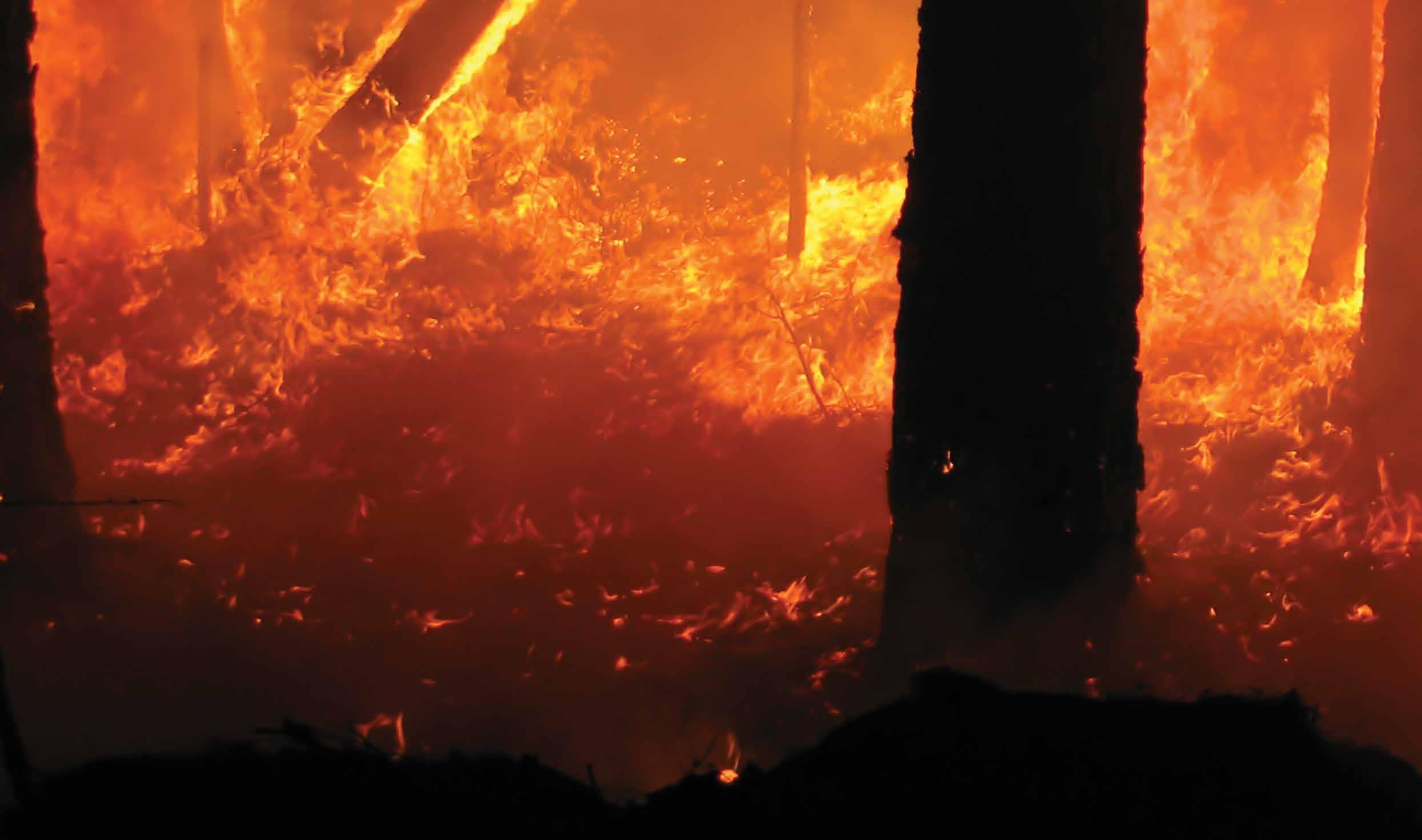
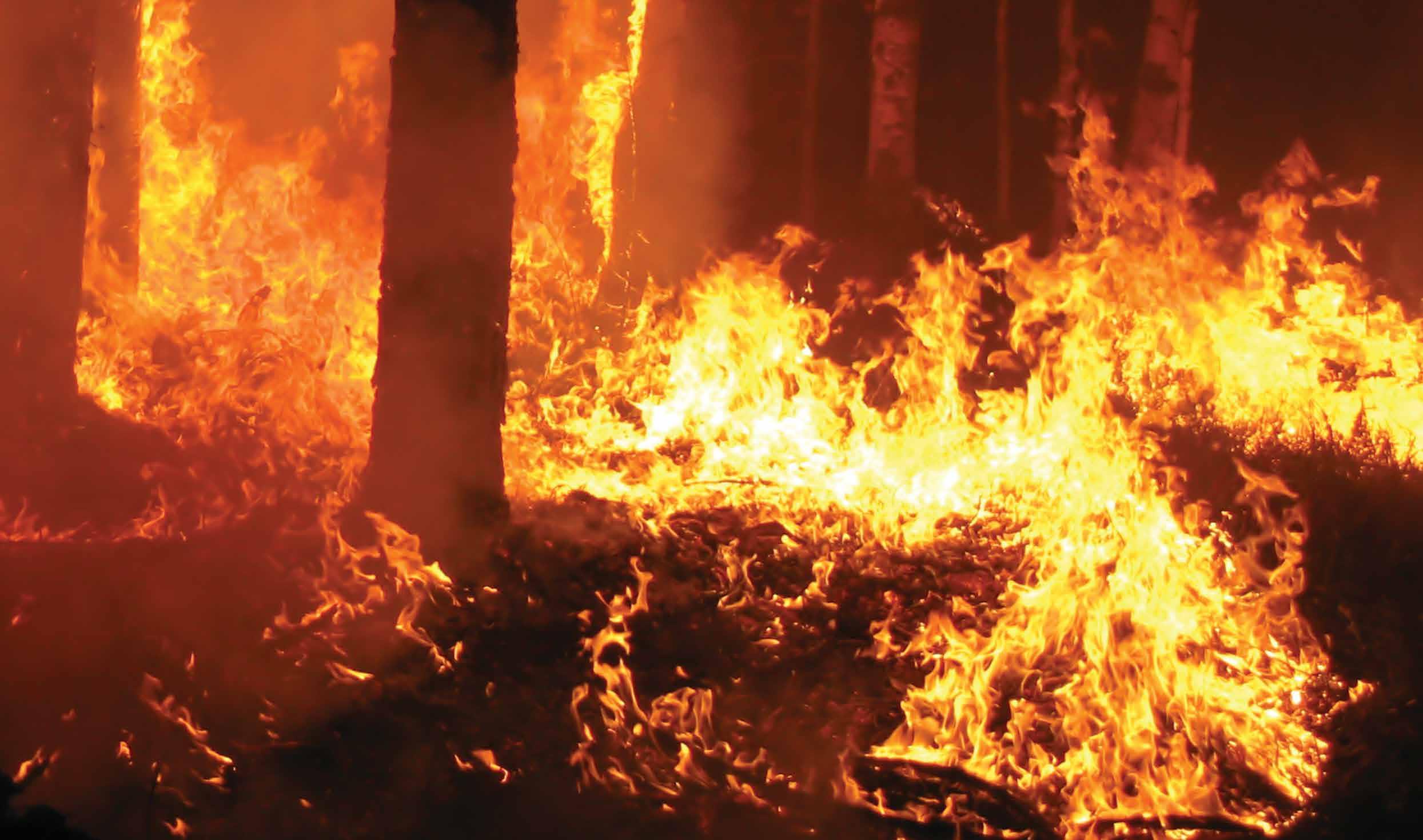
Tropical forests are critical ecosystems, both for those who live there and for the health of our planet. Burning of tropical forests creates a major air quality problem for both human and non-human inhabitants. And on the global scale, managing emissions from the burning of tropical forests is an important element of international strategies to combat global climate change. The fate of these forests should therefore be a concern for everyone.
Representing over half of the Earth’s tropical rainforest, the Amazon Basin is an ecological goldmine, containing over 390 billion individual trees representing 16,000 species. Though environmental groups talk about the myriad of animal species that inhabit the Amazon forest, many of them endangered due to the destruction of the forest, the atmospheric effect of the great expanse of greenery is perhaps more noteworthy. Photosynthesis carried out by the Amazon’s plants is responsible for the absorption of massive amounts of CO2 from the atmosphere, and the release of oxygen into the atmosphere on a daily basis – 20% of the earth’s oxygen actually. For this reason, the Amazon, along with the other rainforests of the earth, are often called ‘The Lungs of the World’.
Furthermore, half of the water in the Amazon is actually held in the trees themselves, and much of the rain that falls in the rainforest results from transpiration of moisture from the green leaves. Importantly, the sheer mass of vegetation alone, being organic material, represents a repository of approximately 17% of the global terrestrial vegetation carbon. However, this carbon stored in the trees and other vegetation is converted to atmospheric CO2 and other pollutants such as carbon monoxide (CO) if the forest is burned. This is the danger of deforestation – the cutting and burning the rainforest to produce farming and grazing land or for human roads and building – replacing active ‘lungs’ with massive amounts of CO2 and other gases. This is where Dr Merritt Deeter and his colleagues come in. They use data from NASA satellites and earth monitoring stations to visualise and measure gases released from the Amazon and other sites around the globe to better understand how the Earth’s ‘breathing’ is being affected by human and natural processes.
Download
Share
Getting Data Is One Thing – Understanding It Is Another
‘I’m generally intrigued by the application of technology to large-scale environmental problems, but I have a special interest in satellite remote sensing instruments and techniques,’ Dr Deeter tells Scientia. While satellite-based methods for studying air quality and climate change have progressed dramatically over the last twenty years or so, like technology everywhere, the interpretation of the observations in these datasets is often still challenging. In other words, just because you get numbers from an orbiting satellite, you have to know what those numbers mean. If an infrared picture of the forest or the desert is red on your screen, does that mean the area is hot or cold? How do you interpret the raw data? How do you validate your final results with the actual conditions on the ground (or in the atmosphere)? Of course, you need the data first. That’s what Dr Deeter uses a NASA satellite for – to obtain data on atmospheric concentrations of CO.
When You Want Data from Space, Get on Board with NASA
When one thinks of NASA, one thinks of astronauts and space shuttles. However, NASA has a long history of working on environmental issues. Dr Deeter’s specific interest lies with NASA’s satellite called Terra, the flagship of NASA’s Earth Observing System. Launched in 1999 in a circular sun-synchronous polar orbit that takes it around the world every 99 minutes, Terra is about the size of a small school bus and contains five instrument packages for observing the various environmental systems of the earth. Terra’s instruments include an Advanced Spaceborne Thermal Emission and Reflection Radiometer (ASTER), a Clouds and Earth’s Radiant Energy System (CERES), a Multi-angle Imaging Spectroradiometer (MISR), an instrument called Measurements of Pollution in the Troposphere (MOPITT), and a Moderate Resolution Imaging Spectroradiometer (MODIS). Dr Deeter’s pet instrument in recent years has been MOPITT.
What Dr Deeter refers to as his ‘day job’ involves algorithm development for the MOPITT instrument. He describes MOPITT as a special type of radiometer which measures atmospheric CO concentrations using measurements in two distinct spectral regions. CO is toxic at high concentrations, and can also be converted into CO2 in the atmosphere, thus contributing to global warming. CO is also involved in the production of ozone, another health hazard. Atmospheric CO is generated primarily through combustion, such as fossil fuel burning and biomass burning. This biomass burning is the same thing that occurs in the deforestation of the Amazon, for example – vegetation is burned to clear areas for human endeavours. Dr Deeter leads the development of the algorithms and software used to generate the MOPITT CO data information that is made publicly available through NASA. He is also frequently involved in developing new applications for MOPITT data, such as the estimation of biomass burning emissions using data assimilation. In other words, if you want to know how much CO is being produced by the burning of the Amazon, Dr Deeter is your man.
‘I’m generally intrigued by the application of technology to largescale environmental problems, but I have a special interest in satellite remote sensing instruments and techniques’

MOPITT Versions Just Get Better and Better
MOPITT is designed to permit retrievals of tropospheric profiles of CO using both thermal-infrared (TIR) and near-infrared (NIR) observations. Such measurements of CO enable air quality forecasts, along with a variety of studies of pollution sources, transport, and atmospheric chemistry. MOPITT has been operational since 2000 and understandably there has been a learning curve in the development of the data processing software. Because of accumulated knowledge regarding the instrument, forward modelling methods, and geophysical variables, the MOPITT retrieval programming has improved continuously from the beginning.
The most recent version of MOPITT programming, Version 6, was developed by Dr Deeter and his NCAR team and was subsequently published in the journal Atmospheric Measurement Techniques. Dr Deeter and the group addressed a geolocation bias related to the orientation of the MOPITT instrument relative to the Terra platform and eliminated it in the new version. The improved geolocation data will benefit analyses of CO variability on fine spatial scales, including data derived from areas of urban pollution. They reduced a retrieval bias issue in the upper troposphere, which should help studies of trace gas variability in the upper troposphere and lower stratosphere. They also updated baseline CO calculations based on more a recent climatology model instead of older data, which should result in better background CO concentrations, particularly near regions of the actual CO source. Lastly, Dr Deeter and his group used a more recently available source of meteorological data, offering improved spatial resolution for atmospheric variables and a more physically appropriate source for surface temperature. Better programming means better CO data, which they were able to conclusively demonstrate by comparing Version 6 products with in-situ data. So, what does that data tell you?

Looking at Carbon Monoxide on the Amazon’s Breath
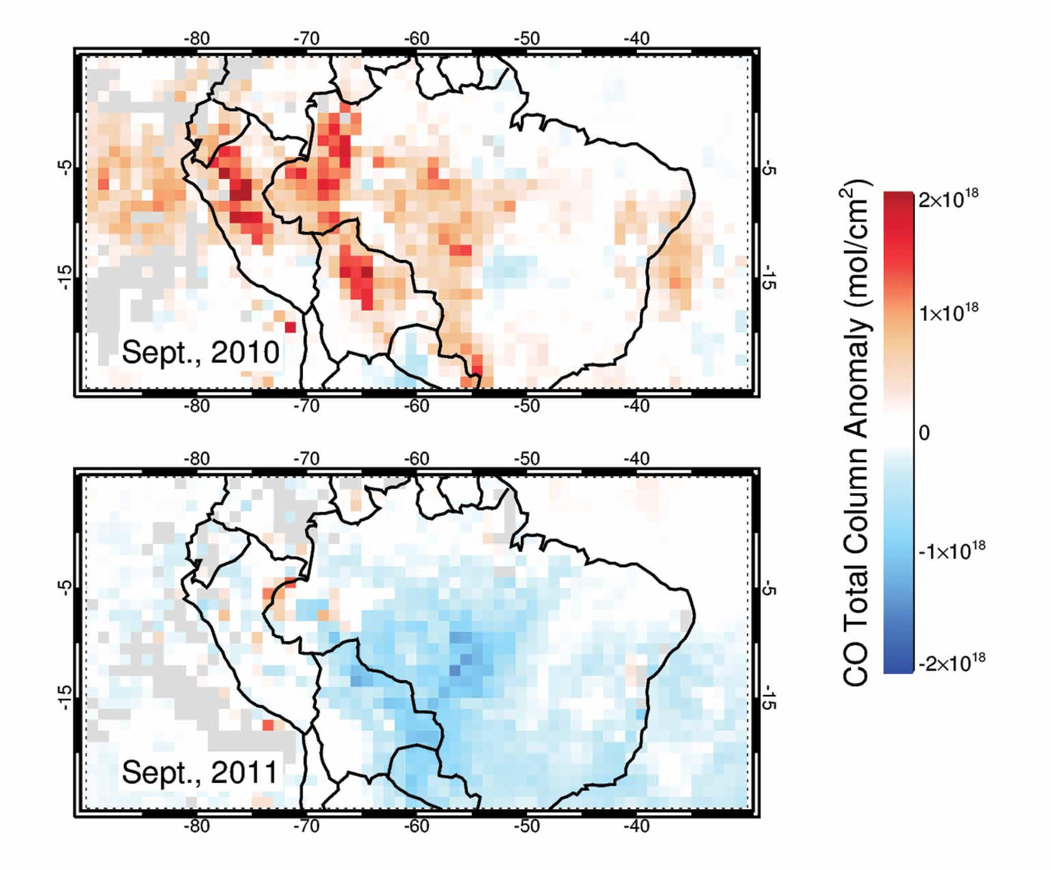
In a more recent publication in Atmospheric Measurement Techniques, Dr Deeter and his colleagues turned their attention to the Amazon. They analysed satellite retrievals of CO from MOPITT over the Amazon Basin, focusing on the MOPITT Version 6 ‘multispectral’ retrieval product that uses both TIR and NIR data channels. They validated their results based on local in-situ profiles measured between 2010 and 2013 at four sites in the Amazon Basin.
Their results showed a significant negative bias in retrieved lowertropospheric CO concentrations that they thought might be due to interference from smoke that obscures some areas when there is active biomass burning. They investigated this possible influence of smoke using ground measurements at two sites but it did not appear to be significant. Other possible causes of the mysterious bias are being investigated. They also compared TIR-only and TIR-NIR measurements and found enhanced sensitivity to CO in the lower troposphere for the TIR-NIR combination, especially during the Amazonian dry season. So using both sets of measurements at the same time was clearly beneficial.
All in all, their CO calculations were in agreement with historic values. However, an analysis of the history of monthly averages for the Amazon Basin showed that the largest CO emissions occurred in years when drought-driven fires burned very large areas. This may be a cause for alarm, since the more deforestation there is, the higher the likelihood of drought is. Recall that the Amazon vegetation produces much of its own rain. Less vegetation, less rain, more drought, more fires, more CO. It’s a vicious cycle and one that data like Dr Deeter’s can shed light on as his team’s research progresses.
What Are the Group’s Future Plans?
Dr Deeter’s group and colleagues around the world have more work to do. ‘My team is currently optimising the data assimilation system which integrates MOPITT observations and an atmospheric chemical transport model. The data assimilation system is being developed and tested by Dr Ave Arellano at the University of Arizona. A key element of this system is the representation of vertical mixing of biomass burning products in the chemical transport model,’ he explains. In other words, when you burn the trees and the smoke rises, what happens to it and where does it go.
The height to which smoke plumes rise largely determines the direction the smoke travels and how quickly it disperses. For this challenge, he says, ‘members of my team are developing a parameterisation for predicting smoke plume heights over the Amazon Basin.’ This work is being led by Dr Maria Val Martin at the University of Sheffield (UK). When the assimilation system is complete and runs are conducted for specific years, the team will need to validate the assimilation results. That will involve comparisons of CO concentrations from the assimilation with independent in-situ measurements from a variety of sources including several field campaigns. Who knows? Maybe Dr Deeter and some of his group will have to put their boots on the ground in the Amazon rainforest and let it breathe on them directly.
Meet the researcher
Project Scientist III Atmospheric Chemistry Division National Center for Atmospheric Research Boulder,
Colorado,
USA
Dr Merritt Deeter received his PhD in Optical Sciences at the University of Arizona in Tucson in 1988. Dr Deeter then joined the National Institute of Standards and Technology in Boulder, Colorado, where he led a team of five researchers in the Optoelectronics Division developing fibre optic instruments. He and his team developed and characterised new optical materials and Dr Deeter was Principal Investigator on a project to develop high-sensitivity magnetic field sensors. He then studied Atmospheric Science at the University of Colorado in Boulder and received his MSc in 1997, thereafter joining the National Center for Atmospheric Research where he is now a Project Scientist III in their Atmospheric Chemistry Observations and Modeling Laboratory. Dr Deeter specialises in retrieval algorithm development for atmospheric remote sensing measurements, in particular the measurement of clouds and trace gases. He also works on radiative transfer modelling, validation methods, and data analysis. In particular, Dr Deeter is formerly the Principal Investigator on the project named Measurements of Pollution in the Troposphere (MOPITT), a satellite remote sensing instrument for monitoring the emission and transport of carbon monoxide around the world.
KEY COLLABORATORS
David Edwards, National Center for Atmospheric Research
John Gille, National Center for Atmospheric Research
Sara Martinez-Alonso, National Center for Atmospheric Research
Helen Worden, National Center for Atmospheric Research
Jim Drummond, University of Dalhousie
Ave Arellano, University of Arizona
Emily Fischer, Colorado State University
Maria Val Martin, University of Sheffield
John B. Miller, NOAA
Luciana Gatti, National Institute for Space Research (Brazil)
FUNDING
US National Aeronautics and Space Administration (NASA)
REFERENCES
MN Deeter, S Martínez-Alonso, LV Gatti, M Gloor, JB Miller, LG Domingues and CSC Correia, Validation and analysis of MOPITT CO observations of the Amazon Basin, Atmospheric Measurement Techniques, 2016, 9, 3999–4012.
MN Deeter, S Martínez-Alonso, DP Edwards, LK Emmons, JC Gille, HM Worden, C Sweeney, JV Pittman, BC Daube and SC Wofsy, The MOPITT Version 6 product: algorithm enhancements and validation, Atmospheric Measurement Techniques, 2014, 7, 3623–3632.