
Dr Michael Gipp | Unveiling the Past: Using Statistical Computation to Characterise Ancient Climates
Throughout the earth’s history, the prevailing climate has changed over and over. To gain insights into the history of our planet, scientists use clues uncovered from the earth’s surface. However, not all periods in the earth’s history are equally represented in the geological record. Dr Michael Gipp is using the surprising similarities between computer algorithms and complex natural systems to describe our ancient climates.
Picturing the Weather
To help create a picture of the earth’s climate millions of years ago, researchers study clues known as ‘markers’ left behind in the geological record. For example, the presence of certain chemical elements can reveal factors such as the oxygen content in the air, or the average rainfall during a past era. However, these markers only give us a very narrow snapshot of the overall climate at the time they were formed, and to create a full picture of the system, researchers are turning to computational models.
Computational modelling methods are incredibly useful when it comes to systems that are too difficult to perform experiments in real life, or to recreate the conditions of a system in the long distant past – such as ancient climate systems. In order to create a computational model, scientists need to determine what the inputs of the system should be, what the outputs should be, and how the two are related. By building up these hypothetical relationships, scientists can change one input, run the simulation, and see what effect that has on the outputs.

The Earth as a Computer
Geophysicist and sedimentologist Dr Michael Gipp has introduced a method to computationally describe the dynamics of chaotic systems. The underlying assumption is that chaotic natural systems can be likened to computation, and as such, can be studied in the same manner. From this perspective, the climate of the earth can be seen as a series of inputs and outputs. An example input is the strength of the sun, and if we were to change the amount of energy the sun puts out then the output, the global temperature, would also change. Clues left behind by ancient climates in the geological records include magnetic sediments and specific chemical isotopes (types of atoms).
The climate of the earth is an incredibly complex system, with a huge number of different potential inputs and outputs. To further complicate this, some of the inputs may be dependent on each other, and are therefore also outputs! Dr Gipp recently likened this to working out the computational details of an unknown programme running on an unknown operating system with an unknown computational architecture.
This may sound like an insurmountable problem, but by using some clever algorithmic tricks researchers can tease out information from very limited starting data. Dr Gipp aims to create a description of the invariant properties of the climate in central Asia starting from 2.2 million years ago. The climate at the time – the Asian Paleomonsoon – was characterised by high levels of rainfall. In the geological records, a good indicator of the moisture in the climate comes from markers in the soil and sediment layers deposited at the time. From these, Dr Gipp can build up a picture of the climate over millions of years, identifying periods of stability and also when the climate changed rapidly.

Chains of Probability
Dr Gipp starts by building a Markov chain from the sequence of periods of stability in the climate. By building multiple Markov chains relating all the available markers, Dr Gipp forms a ‘hierarchy’ of all the available clues. From this, he can work out what the climate would have been in eras where the geological record is incomplete from the known markers in the record from either side of the gap.
For example, the geological marker ‘A’ is always followed by marker ‘B’, ‘B’ can be followed by ‘A’ or ‘C’, and ‘C’ can be followed only by ‘A’. If the geological record shows marker ‘A’, a gap, then marker ‘C’, then we know that the marker in the gap must be ‘B’. The probability relations between the markers that Dr Gipp is using are rather more complex, but by building up layers of Markov chains in what are called Epsilon Machines, he can build probability maps of which markers were present at different time periods, even if the geological record is missing.
Dr Gipp found that early in the period, the climate was drier and was much more stable relative to the more recent period from around 1 million years ago which has seen much more variation in rainfall. Dr Gipp then compared his results on the rainfall markers to an earlier work of his investigating total global ice coverage. Both sets of markers showed more variation after around 1 million years ago, and the increased variation in magnetic markers for higher rainfall corresponded with a marker that suggested higher total ice coverage. By comparing these patterns, Dr Gipp can now start using markers that show ice levels in his Markov chains to help describe the rainfall and vice versa.
Critically, Dr Gipp’s novel work building a nest of interlinked probability chains also allows him to describe climate events that are not represented in the geological record. As more markers are discovered and added to the algorithm, the characterisations it creates become increasingly accurate, allowing a better understanding of how climate systems have changed over millennia. The next steps are the refinement of the algorithms, helping determine what triggers the transfer from one marker type to the next, and to account for different interpretations of what some markers might mean. Using these computational methods, Dr Gipp is now shining light on the weather of eras long since past.
SHARE
DOWNLOAD E-BOOK

REFERENCE
https://doi.org/10.33548/SCIENTIA902
MEET THE RESEARCHER

Dr Michael Gipp
Marine Mining Corp.
Toronto, ON
Canada
In 1996, Dr Michael Gipp completed his PhD on glacially influenced marine sedimentation at the University of Toronto in Canada. Since then, he has been made a fellow of the Geological Association of Canada and a member of both the American Geophysical Union and the Association of Professional Geoscientists of Ontario. Over his career spanning geology and earth science, Dr Gipp has also taken part in several field research expeditions, such as establishing marine mining feasibility in Ghana, exploration for diamonds in Finland and the Northwest Territories of Canada, and nine geological survey cruises in the western Atlantic Ocean. Dr Gipp has shared his knowledge through various academic posts, teaching on topics ranging from high school maths to university geophysics. Currently, Dr Gipp’s interests are focused on conducting computational studies into paleoclimates and creating new computational tools to understand ancient climates.
CONTACT
W: www.worldcomplex.blogspot.com
FURTHER READING AND RESOURCES
MR Gipp, Extracting Hierarchical Dynamical Structure From a Multistable Geological System—The Himalayan Paleomonsoon, Paleoceanography and Paleoclimatology, 2022, 37(2), e2020PA004176. DOI: https://doi.org/10.1029/2020PA004176
https://worldcomplex.blogspot.com/2011/04/framework-for-applying-computation.html
REPUBLISH OUR ARTICLES
We encourage all formats of sharing and republishing of our articles. Whether you want to host on your website, publication or blog, we welcome this. Find out more
Creative Commons Licence (CC BY 4.0)
This work is licensed under a Creative Commons Attribution 4.0 International License. 
What does this mean?
Share: You can copy and redistribute the material in any medium or format
Adapt: You can change, and build upon the material for any purpose, even commercially.
Credit: You must give appropriate credit, provide a link to the license, and indicate if changes were made.
SUBSCRIBE NOW
Follow Us
MORE ARTICLES YOU MAY LIKE
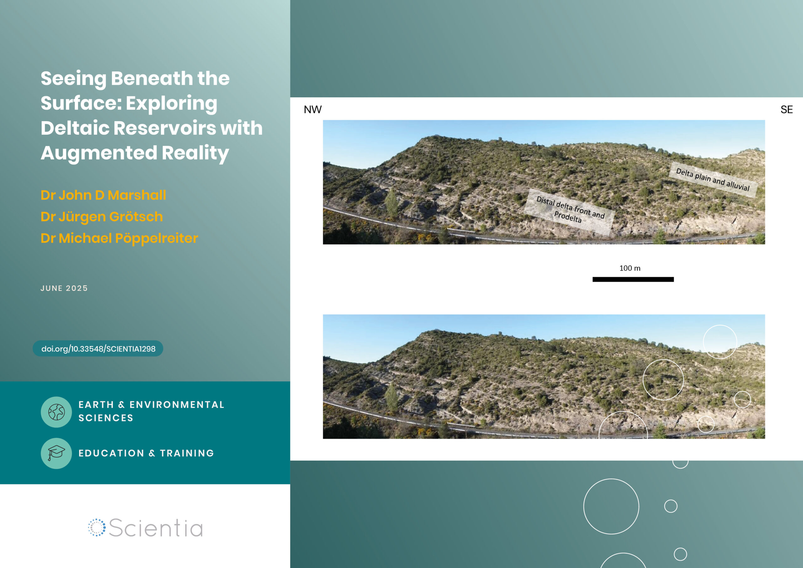
Seeing Beneath the Surface: Exploring Deltaic Reservoirs with Augmented Reality
In the Aínsa Basin of the Spanish Pyrenees, the Mondot-1 well was drilled, cored, and fully logged to capture a detailed record of a long-buried ancient river delta system. Dr. John D. Marshall, Dr. Jürgen Grötsch, and Dr. Michael C. Pöppelreiter with co-workers at Shell International used this core to trace how sediments once flowed across the landscape, and were deposited under shifting tectonic conditions. The team employed augmented reality and interactive virtual displays; these innovative tools offer new ways to explore subsurface depositional systems, and are particularly useful in locations where physical access to the core is difficult, or no longer possible.
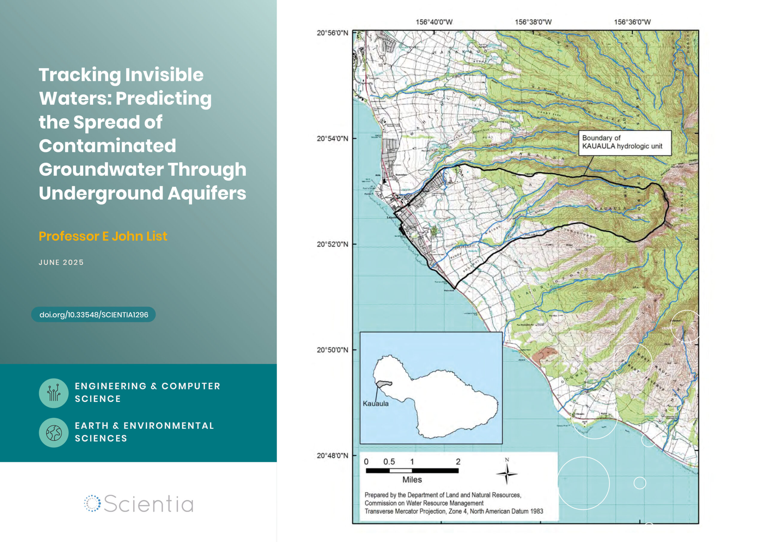
Professor E John List | Tracking Invisible Waters: Predicting the Spread of Contaminated Groundwater Through Underground Aquifers
When we think about water pollution, we often picture oil spills on the ocean surface or chemicals flowing down rivers. But some of the most significant environmental challenges occur completely out of sight, deep underground, where contaminated water moves through layers of rock and soil. Understanding how these invisible pollutants travel has profound implications for protecting our drinking water supplies and coastal ecosystems. Groundwater engineer Dr E. John List has developed an approach that challenges fundamental assumptions about how contamination spreads underground.

Dr Richard Marchant | Restoring the Flow: Stream Life Slowly Returns After Rabbit Eradication on Macquarie Island
The remote streams of subantarctic Macquarie Island are home to low diversity freshwater invertebrate communities with an unusual taxonomic composition. However, over a century of grazing by introduced rabbits dramatically degraded surrounding vegetation, increasing erosion and disturbing stream ecosystems. Following rabbit eradication in 2016, Dr Richard Marchant of Museums Victoria and colleagues from the University of Canberra and the Australian Antarctic Division investigated whether the island’s streams were recovering ecologically. Their study reveals a slow but measurable resurgence of invertebrate taxa, particularly in areas with moderate prior damage and vegetation regrowth, though full recovery remains uncertain.

Rediscovering Alfred Russel Wallace: The True Location of His Ternate Residence
In February of 1858, naturalist and explorer Alfred Russel Wallace, whilst in the village of Dodinga at Halmahera Island, Indonesia, independently outlined his theory of evolution through natural selection.
Wallace then returned to his rented home on the small island of Ternate, and sent his manuscript —now known as “The Ternate Letter”— to Charles Darwin.
For nearly 80 years Wallace’s rented house has been a subject of debate, with two houses contending as candidates albeit, as this paper confirms, neither being valid. The paper written by Paul Whincup describes how a combination of new research, fieldwork, and local insight has finally pinpointed the true site of Wallace’s House at Ternate.