
Rediscovering Alfred Russel Wallace: The True Location of His Ternate Residence
Article written by Janine Galliano, MSc
In February of 1858, naturalist and explorer Alfred Russel Wallace, whilst in the village of Dodinga at Halmahera Island, Indonesia, independently outlined his theory of evolution through natural selection.
Wallace then returned to his rented home on the small island of Ternate, and sent his manuscript —now known as “The Ternate Letter”— to Charles Darwin.
For nearly 80 years Wallace’s rented house has been a subject of debate, with two houses contending as candidates albeit, as this paper confirms, neither being valid. The paper written by Paul Whincup describes how a combination of new research, fieldwork, and local insight has finally pinpointed the true site of Wallace’s House at Ternate.
Wallace’s Island Workshop
Located on the small volcanic island of Ternate Indonesia, the Wallace House is renowned for its great historical significance. In 2008, Marzuki, who was then the president of the Wallace Foundation in Indonesia, considered it ‘the most important science history site in Indonesia.’
From January 1858 to January 1862, Alfred Russel Wallace was based on Ternate Island, and supported himself by collecting exotic natural history specimens and selling them to European collectors.

In 1858, while bedridden with a tropical fever on the nearby island of Halmahera, Wallace had an epiphany. Over several nights, he outlined a bold new theory — evolution by natural selection. He returned to his house on Ternate on the 1st of March 1858, with the intention of catching the next mail boat on the 7th of March. During these days, he may have re-written out his theory, and added a few corrections, but no one can know for sure. Wallace then posted his theory along with an accompanying letter (the famous Ternate Letter, which unfortunately was not saved) to none other than Charles Darwin.
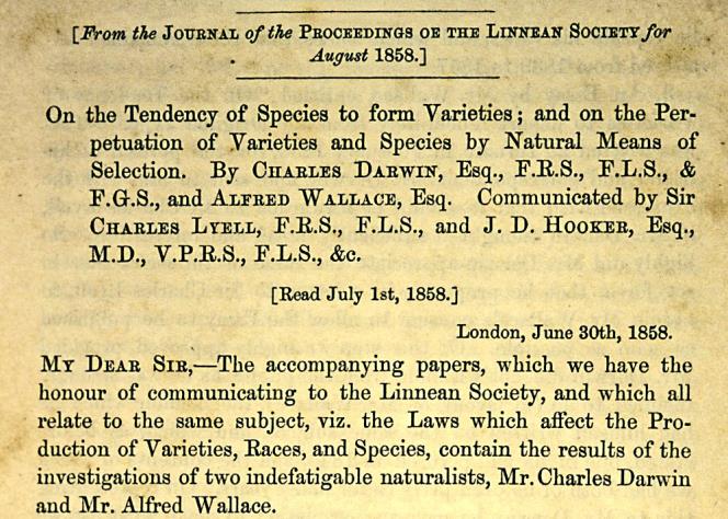
Darwin was understandably impressed but also unsettled. In just a few pages, Wallace’s theory had captured the very idea Darwin had been researching and developing for years, but had not yet published. The result was that both Darwin and Wallace presented to the Linnean Society on the 1st of July 1858.
The Search for a Scientific Landmark
Interest in the location of Wallace’s house first surfaced during World War II, when Ternate was occupied by the Japanese and a Japanese engineer lived in what is now the Santiong House and advised local residents it was the house where Wallace had lived. After that it faded for more than four decades until the city of Ternate endorsed two possible sites: the so-called Sultan’s House in the 1980s, superseded by the Santiong House in 2008. However, in 2012, Wallace expert Beccaloni raised doubts, claiming that neither house matched Wallace’s own descriptions in his “Travels In The Malay Archipelago”. This prompted Paul Whincup to launch a new investigation in 2018, which ultimately led to the identification of the true site, now known as the Oranje Site.
Wallace’s Written Clues
Wallace offered this description of the house and its setting:
There is of course only one floor. The walls are of stone up to three feet high; on this are strong squared posts supporting the roof, everywhere except in the veranda filled in with the leaf-stems of the sago palm, fitted neatly in wooden framing. The floor is of stucco, and the ceilings are like the walls. The house is forty feet square consists of four rooms, a hall, and two verandas, and is surrounded by a wilderness of fruit trees.
The lower part of the mountain, behind the town of Ternate is almost entirely covered with a forest of fruit trees. A deep well supplied me with pure cold water. Five minutes’ walk down the road brought me to the market and the beach. In the opposite direction there were no more European houses between me and the mountain. Just below my house is the fort, built by the Portuguese (n.b. it’s actually a Spanish fort), below which there is an open space to the beach. Beyond this the native town extends for about a mile to the northeast. About the centre of it is the palace of the Sultan.
In hindsight, only three or four sites at the southwestern corner of Fort Oranje could have matched Wallace’s description, but early researchers overlooked this, possibly influenced by local residents.
The Misidentified Houses of Ternate
When British explorer Tim Severin visited the Sultan House in 1996 (The Spice Islands Voyage, 1999), he noted it did not meet the dimensions detailed by Wallace, being larger and more opulent, with stone pillars rather than wooden uprights.
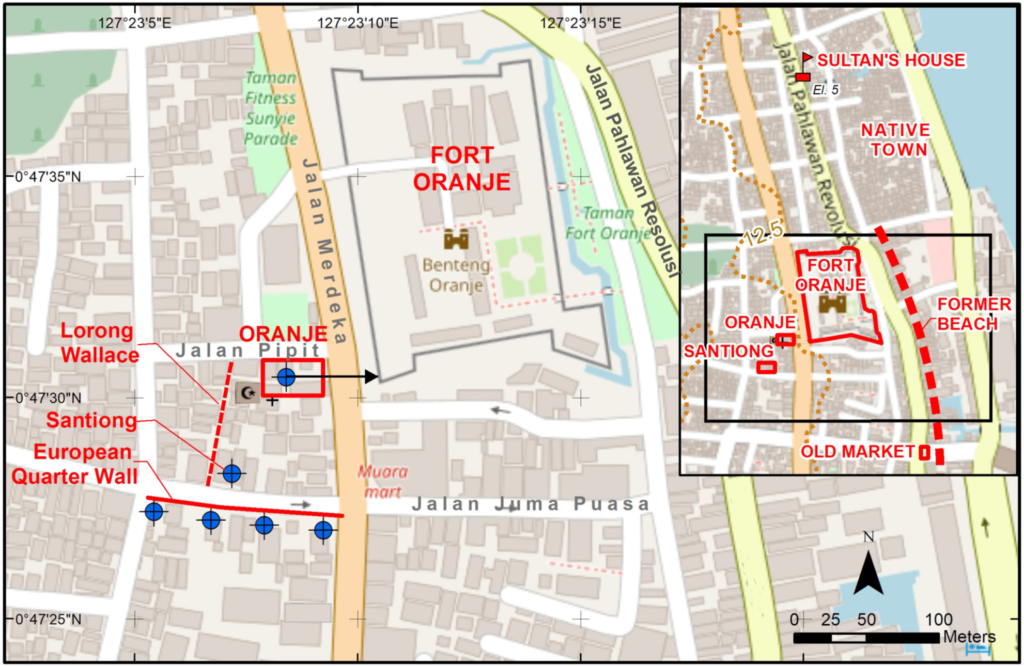
The Santiong House was formally accepted as the Wallace House after a presentation by Marzuki and Andilito to the International Conference on Alfred Russel Wallace in Makassar, in December 2008. The presentation by Marzuki and Andili (2015) recounted the story of the Japanese engineer, and identified two old wells, which they were “reasonably confident” were the only ones in the area. One was located at the Santiong House, facing what they referred to as the “Portuguese Fort,” and the other —later confirmed by the deep well survey— was across the road, in what would have been the European Quarter. Supporters of the Santiong House claimed that the remains of a wall opposite the Santiong House were a remnant of a Portuguese Fort, though no such structure is documented in the historical record.
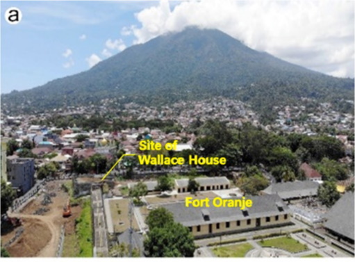
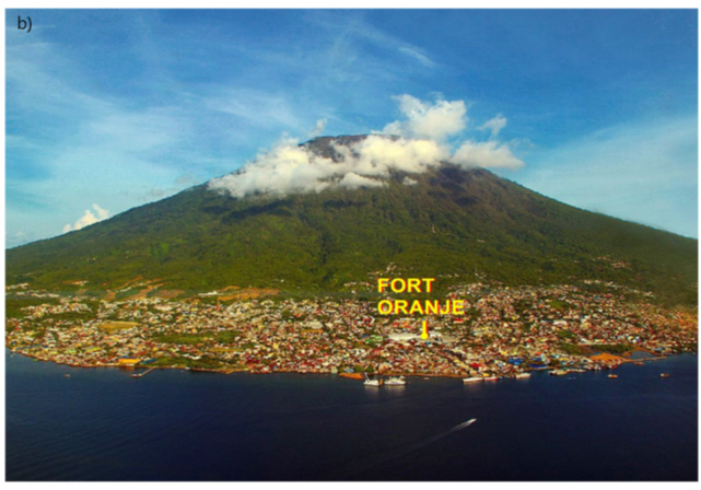
The site of the Wallace House; Photo Sinclair Stammers.

View from Fort Oranje to the Oranje Site across Jln Merdeka to Jln Pipit, formerly the track used by Wallace; Photo George Beccaloni ©, 2019
Discovering the True Site of Wallace’s Ternate House
After accessing the Wallace Foundation website in September 2018, Whincup recognised the significance of the deep wells, knowing these to be long-established, and proposed that a deep well survey of the Santiong District be carried out.
Further research was conducted between October and December 2018, which drew on several key sources. One was a map outlining the Dutch Quarter, clearly showing its northern boundary aligning with the remains of the wall opposite the Santiong House thus providing conclusive proof that the wall was not part of a Portuguese Fort. Another was an account by De Clerck, which described a walk southward from the “native town”, past Fort Oranje. He noted that the land immediately west of the fort excepting at its southernmost extent was used as a military training ground, so no houses existed there.
With the assistance of two local residents in 2019, a door-to-door survey of Santiong households was conducted to investigate the presence of old deep wells. This proved to be the most significant breakthrough in the research, leading to the identification of the exact location of Wallace’s house. Completed in January 2020, the survey uncovered a deep well at the corner of Jalan Merdeka and Jalan Pipit, looking down to Fort Oranje, and matching all the clues provided by Wallace. This discovery was formally recognized by Ternate City on the 2nd of September 2019, and has since been endorsed by successive mayors. There are hopes that funding will be secured to purchase the site, where a replica of Wallace’s house can be built to serve as a museum and research centre.
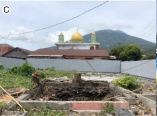
The site in February 2020 after it had been cleared and boarded; Photo Krithika Varagur 2021
SHARE
DOWNLOAD E-BOOK

REFERENCE
https://doi.org/10.33548/SCIENTIA1292
MEET THE RESEARCHER
Paul Whincup
PT EnviroSolutions and Consulting (ESC)
Paul Whincup obtained his Bachelor of Science, with Honours, in Geology with Chemistry, in 1962, from the University of St. Andrews, Scotland. Throughout his career, he has specialised in water resource management, and is recognised as an international water expert. Whincup has had experience working in over forty countries. He represents PT EnviroSolutions and Consulting (ESC), where he provides Peer Review for all ESC water-related projects in Asia, as well as Environmental Social Impact Assessments, to ensure alignment with International Finance Corporation Performance Standards.
Whincup is a member of the International Association of Hydrogeologists, and the Australian Water Partnership, and has held leadership roles in industrial organisations, as well as publishing numerous articles on water-related matters in leading journals.
CONTACT
Tel: +61493133246
KEY COLLABORATORS
Fiffy Sahib
Mudhi Aziz
Royal Society of Western Australia
FURTHER READING
Beccaloni, G. and Beccaloni, J. 2013. In the footsteps of Alfred Russel Wallace with Bill Bailey. Oxford University Press’s Academic Insights for the Thinking World.
De Clercq, F.S.A. 1890. Ternate: The Residency and its Sultanate, Leiden, Brill. P.M. Taylor’s revised re- publication Washington, D.C.: Asian Cultural History Program, Smithsonian Institution, 2018. https://www.sil.si.edu/DigitalCollections/anthropology/ternate/ternate.pdf
Huxley T H 1868, On the Classification and Distribution of the Alectoromorphae and Heteromorphae. Proceedings of the Zoological Society of London 1868, 294–319.
Marzuki, S. & Syamsir, A. 2015. The Ternate of Alfred Russel Wallace, TAPROBANICA, ISSN 1800–427X, May 2015. Vol. 07, No. 03: I–X.
Niizuma, A. 1997. Seeking the Origin of Species ~ Exploring Wallace’s Malay Archipelago, Asahi Shimbun, Tokyo.
Severin, T, 1997. The Spice Islands Voyage: In Search of Wallace, Little, Brown and Company, London Stammers, S. 2018.
Wallace, A.R. 1869. The Malay Archipelago: The Land of the Orang-utan, and the Bird of Paradise. Macmillan and Company, London. (Periplus Classic Edition of 2008; 313).
Whincup, P. 2020. The Quest for Wallace’s Legendary Ternate House, Journal of the Royal Society of Western 225 Australia, 103: 50-54.
![]()
REPUBLISH OUR ARTICLES
We encourage all formats of sharing and republishing of our articles. Whether you want to host on your website, publication or blog, we welcome this. Find out more
Creative Commons Licence (CC BY 4.0)
This work is licensed under a Creative Commons Attribution 4.0 International License. 
What does this mean?
Share: You can copy and redistribute the material in any medium or format
Adapt: You can change, and build upon the material for any purpose, even commercially.
Credit: You must give appropriate credit, provide a link to the license, and indicate if changes were made.
SUBSCRIBE NOW
Follow Us
MORE ARTICLES YOU MAY LIKE

Dr Suzan Ilcan | Building Bridges Across Difference: How Women Refugees and Volunteers Foster Solidarity in Cyprus
Across Europe, refugees and asylum seekers often find themselves in precarious situations, facing limited access to housing, employment, education, and legal protection. While government responses have frequently proved inadequate, grass-roots movements have emerged to fill the gaps. These citizen-led initiatives represent more than simple charity; they embody new forms of political engagement where refugees and volunteers work together across differences to create useful change.
This issue is particularly pressing in the Republic of Cyprus (RoC), where the island’s own history of division and displacement shapes contemporary responses to newcomers. Since 2015, the RoC has experienced a dramatic increase in refugee arrivals, making it the EU member state with the highest number of asylum applications per capita in 2021. Yet despite – or perhaps because of – this pressure, women in the Cypriot city of Paphos have created remarkable spaces of collaboration and mutual support.

Prof Han Lamers | How Early Modern Scholars Used Ancient Greek to Shape Their National Identities
In early modern Europe, ancient Greek was far more than a scholarly pursuit. Intellectuals from many regions discovered that demonstrating resemblance of their native languages to Greek could elevate their cultural status, support claims of superiority over rival languages, and even advance religious and political causes. Sometimes called ‘Hellenising’, this phenomenon saw scholars from Italy to France, Germany, and the Netherlands, deliberately revealing —and often inventing— Greek features in their mother tongues.
Understanding how this worked requires examining specific cases where scholars used Greek to reshape their languages and advance their own agendas.

Nick Martin | Data Assimilation: Overcoming AI’s Data Uncertainty Limitations for Water Resources
Water resources are essential for human life. Knowing how to manage water, both now and in the future, is necessary to continue using it as well as possible. Nick Martin and Jeremy White are examining limitations to artificial intelligence applications in water resources generated from noisy and estimated data sets. For poor quality data sets, they found that machine learning models will perform poorly relative to tools that explicitly include physics-based descriptions of physical processes; this is because physics-based calculations can use both data and physics knowledge through data assimilation techniques.

Nick Martin | The Future of Floods: Smarter Risk Tools for Sustainable Water Management in a Changing Climate
Sustainable decision-making requires balancing the costs borne by today’s society with those that will fall on future generations. Climate change is intensifying extreme weather, making floods more severe because a warmer atmosphere can hold and deliver a larger volume of water as precipitation. It may also be the case that severe floods are becoming more frequent as drought becomes more frequent, average conditions rarely occur, and weather oscillates between short duration wet and long duration dry extremes. Worryingly, traditional infrastructure (often designed using outdated, backward-looking models) risks failing under these evolving conditions.
Nick Martin from Vodanube LLC, and his colleagues have applied Probabilistic Risk Assessment (PRA) to flood inundation. Their research optimises current adaptation and future mitigation strategies, even while acknowledging PRA’s limitations. The team demonstrates how this approach can guide more resilient water resource management, and highlights opportunities for further study.