
Dr Dan Lubin | AWARE: Critical Climate Data Informs West Antarctic Ice Melt
The West Antarctic Ice Sheet (WAIS) is one of Earth’s most rapidly warming regions, holding huge implications for global ocean rise and large-scale weather events. Yet, despite its influence on large-scale climate patterns, the WAIS remains one of Antarctica’s most poorly studied areas. Dr Dan Lubin, of the Scripps Institution of Oceanography at the University of California, San Diego, brought renewed interest to this neglected but critical region with the AWARE programme, one of Antarctica’s most extensive scientific campaigns yet. The programme seeks to improve our understanding of the physical processes influencing the West Antarctic to improve global model simulations.
The ARM West Antarctic Radiation Experiment
Beginning with the 1957 International Geophysical Year, researchers conducted atmospheric observations in West Antarctica including radiosondes, but these critical observations ended by 1967. After that, only a small handful of Automatic Weather Stations (AWS) provided basic surface meteorological data for the West Antarctic, one of the most remote regions on the continent. It wasn’t until 48 years later that scientists returned to collect more data in the area. By that time, in 2015, the climate had changed significantly. Collectively, humans emitted an astonishing >30 billion more tonnes of greenhouse gases between 1967 and 2015, fundamentally altering weather patterns and causing large-scale ice melts threatening to cause global sea level rise. Studying weather patterns in this region has always been important, but collecting accurate climate data is now imperative in the face of climate change.
Antarctica contains around 90% of Earth’s ice, and West Antarctica’s floating ice shelves stabilise the continent’s ice sheets. Any changes in air circulation that affect surface warming in the West Antarctic can threaten the integrity of these ice sheets and contribute to massive global sea level rise. To accurately predict how Antarctica’s ice sheets will respond to changing weather patterns, we must understand how much heat radiation makes it to the ice to cause surface melt.
Unfortunately, the region’s remoteness has made it challenging to establish advanced atmospheric science set-ups like those present in the other areas of Antarctica. In 2015, a team of researchers led by Dr Dan Lubin from the Scripps Institution of Oceanography, partnered with the Atmospheric Radiation Measurement programme (ARM; managed by the United States Department of Energy) and the United States Antarctic Program (USAP; managed by the National Science Foundation). ARM collects atmospheric data in climate-critical areas worldwide. Dr Lubin and his colleagues spearheaded efforts to establish the ARM West Antarctic Radiation Experiment (AWARE) to gather critical climate data on the West Antarctic Ice Sheet (WAIS).
Using ground-based measurements, satellite data and atmospheric modelling, AWARE investigates how atmospheric radiation affects the ice sheet to contribute to our understanding of the broader climate system. The project has already provided significant insights into our understanding of WAIS. Using the most advanced and complete set of equipment for atmospheric and climate science ever sent to Antarctica, climate scientists are already using AWARE’s massive dataset to test and refine the climate models we use to predict and prepare for climate change.
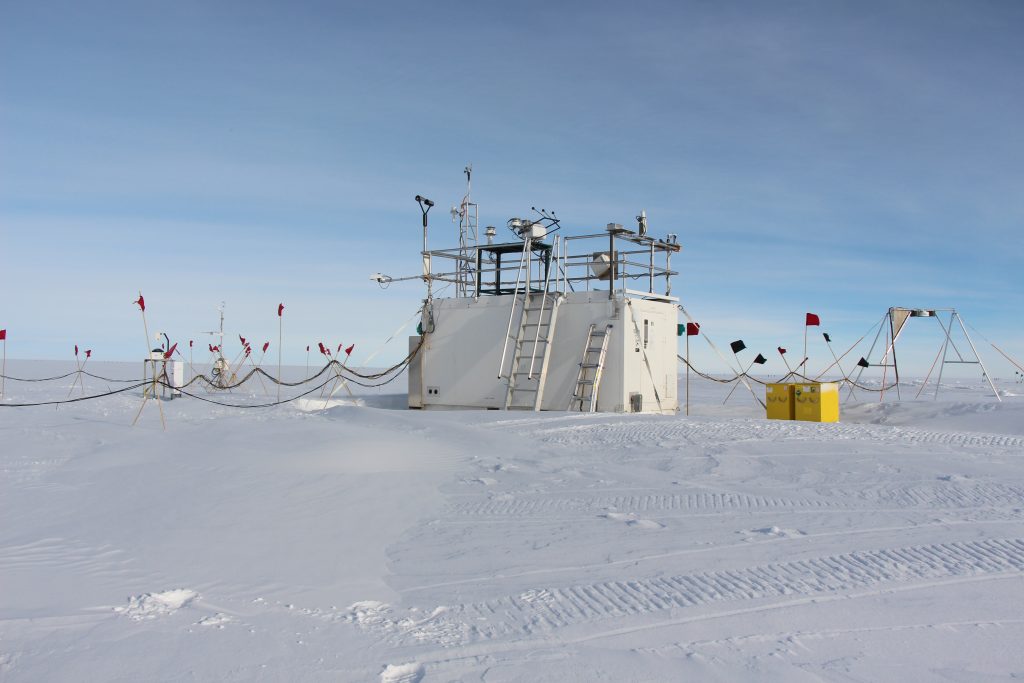
A sonic anemometer measuring nearsurface turbulent energy fluxes at Siple Dome in West Antarctica. Credit: Dan Lubin.
An Impressive Dataset
In the first round of AWARE measurements, the team deployed some ARM climate research facility equipment directly on the WAIS ground near an ice-core drilling station. This effort represented the first climatological suite of measurements researchers have taken in this area for over 40 years. This facility was only in place during the Antarctic summer because of the harshness of winter conditions on the equipment.
However, the team also wanted to use the finest, most complex tools available to gather data relevant to cloud formation and aerosols, tiny particles suspended in the atmosphere that come from natural and human-made sources. The closest station where they could deploy this equipment was McMurdo station on Ross Island, adjacent to the Ross Ice Shelf. They set up the equipment, which took measurements from January 2016 to January 2017. Together, the two campaigns – on the WAIS and at McMurdo station – resulted in 14 months of climatological data relevant to the WAIS.
Fourteen months is not long enough to study the long-term effects of climate change on Antarctica. However, with these first measurements on WAIS cloud properties and surface radiation, the researchers hoped the data would help them understand the surface energy balance of Antarctica, which impacts ice melt and sea-level rise.
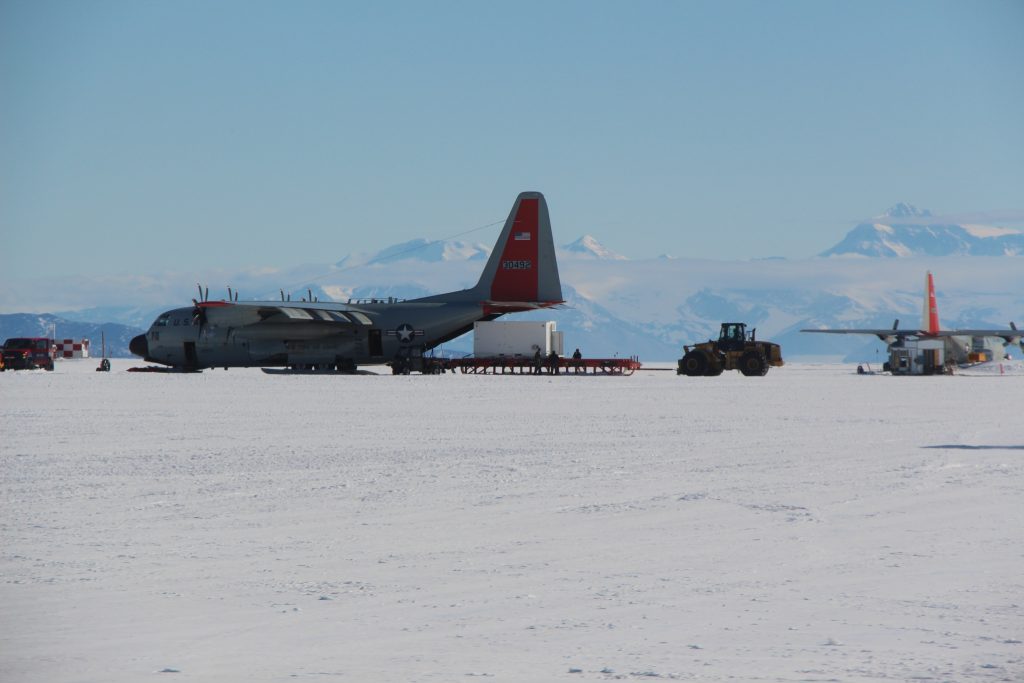
Due to the logistical challenges, AWARE was allowed only one LC-130 aircraft mission to transport equipment and personnel from McMurdo to the WAIS. Credit: Dan Lubin
Initial and Critical Results
A major goal of the AWARE campaign was to compare the Antarctic climate with the better-studied Arctic, which scientists know is strongly influenced by persistent cloud cover. In a 2020 review of the AWARE data by Dr Lubin and colleagues, they found that cloud properties in the Antarctic were significantly different from those in the Arctic. The Antarctic clouds over Ross Island were thinner and less persistent than Arctic clouds. The researchers attribute this difference in cloud properties to the two regions’ unique atmospheric and meteorological conditions. For example, the Antarctic has a much drier atmosphere, which leads to fewer clouds and less precipitation. Also, much of the Antarctic atmosphere over the ice shelves is influenced by adjacent mountain ranges; and the vertical air motions cause different partitioning between liquid water and ice in clouds compared with the Arctic Ocean.
Another key focus of the initial AWARE campaign was to demonstrate the role of aerosols on cloud formation and the Earth’s climate. Aerosols are tiny particles suspended in the air from natural and human-based sources. The researchers used a variety of instruments to measure aerosol concentrations, size distribution and properties, such as their ability to absorb or scatter sunlight.
One of the key findings of the AWARE campaign was that the Antarctic has a much lower concentration of aerosols compared with the Arctic. The researchers attribute this finding to the remote and isolated nature of the continent, as well as its low population density and lack of industrial activity. This result implies that assuming similar aerosol composition in the Arctic and Antarctic will lead to incorrect climate model predictions.
Dr Lubin stresses that we shouldn’t ignore or neglect aerosol abundances when creating models that predict cloud cover and composition. The researchers emphasize that Antarctic aerosols likely still significantly influence cloud properties, and their composition and unique properties deserve further study.
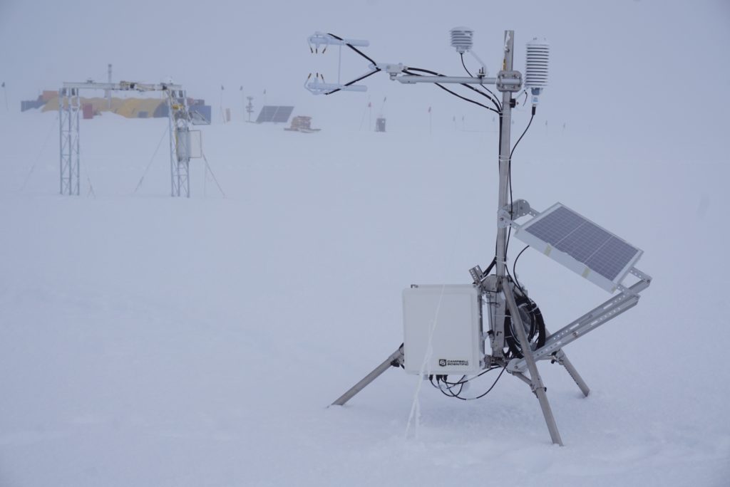
AWARE meteorological and atmospheric remote sensing equipment in operation on the WAIS. Credit: Dan Lubin.
Climate Modelling Applications
The modelling applications now possible due to the AWARE campaign are perhaps the most promising and exciting aspect of the programme. Researchers used a serendipitous event in 2016 when a strong El Niño year coincided with a significant West Antarctic melt event. During El Niño, sea surface temperatures in the Pacific Ocean are warmer than average. Researchers know that ice melts in Antarctica have correlated with the weather phenomenon but lacked the data to investigate the trend further. Fortunately, the AWARE campaign’s sea container equipment at the edge of the melt recorded the meteorological patterns during the melt.
This event and AWARE’s serendipitous data collection allowed scientists to study and test the accuracy of their regional and global climate models. The researchers used the AWARE data to evaluate the popular Polar Weather Research and Forecasting regional model, a version of the Weather Research and Forecasting model.
The researchers compared the model simulations against the actual observations from AWARE. In general, Dr Lubin and his colleagues found that the models failed to capture the relatively high occurrence of liquid water in the clouds, which caused the predicted temperatures to be cooler by several degrees than what was observed. This miscalculation has significant consequences for the model’s estimation of how much energy is in the WAIS snowpack.
The AWARE data analysis also revealed a potential reason why El Niño might cause ice melts. In a 2017 paper examining the event, Dr Lubin and his colleagues propose that El Niño brings warm air to the area, explaining why surface melt tends to be associated with El Niño events. Since experts predict that the frequency of El Niño events will rise over the twenty-first century, the researchers note that more events could promote more frequent melt events. However, the researchers caution that the relationship between El Niño and climate is complex, and we are only beginning to understand how the event influences Antarctic weather patterns.
Overall, this case study demonstrated the ability to use AWARE data to help identify and correct model biases and help scientists study whether we can reliably expect similar ice melts after El Niño events.
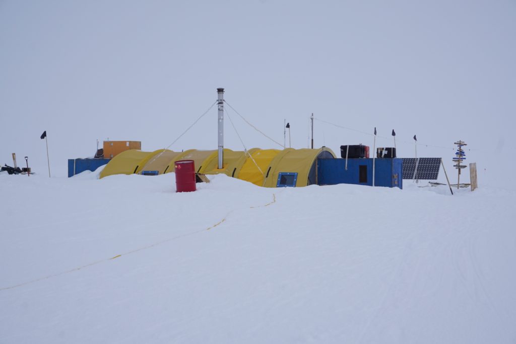
Siple Dome Field Camp, a small summer-only facility in West Antarctica staffed by only four people, where Dr Lubin’s 2019 follow-on campaign was deployed. Credit: Dan Lubin.
Onwards and Upwards
Dr Lubin and his colleagues continue to deploy new portable equipment spun from AWARE’s ARM technology to other areas in West Antarctica. For example, in 2019, Dr Lubin took transportable solar-powered equipment to Siple Dome, an ice plateau in West Antarctica near ice streams of great scientific interest, to take data on surface energy measurements and conduct cloud remote sensing. The goal was to continue data collection on the clouds that persist over Antarctic ice sheets, which regulate how much heat gets to the ice and can induce ice melt that weakens the ice shelf structure.
The expedition showed that AWARE’s follow-on mission to Siple Dome was successful, highlighting the ability of the field equipment to be deployed in even more remote and rugged conditions. Dr Lubin and his team are using these data to validate cloud simulations over the area, and these efforts are ongoing.
Confronting Climate Change
The West Antarctic Ice Sheet is a critical region in the Earth’s climate system, and the AWARE programme is improving our understanding of physical processes in the region. The success of the project is undoubtedly due to the collaborative effort of researchers from different fields and countries. Using the massive dataset generated through AWARE, scientists are already improving their climate models to predict and prepare for climate change.
The programme has broader impacts beyond improving our understanding of the West Antarctic. It is training the next generation of climate scientists and engaging the public in understanding climate change. As we continue to face the threat of climate change, programmes like AWARE are essential to our efforts to mitigate its impact on our planet.
SHARE
DOWNLOAD E-BOOK
REFERENCE
https://doi.org/10.33548/SCIENTIA906
MEET THE RESEARCHER

Dr Dan Lubin
Research Physicist
Scripps Institution of Oceanography (SIO)
University of California, San Diego
La Jolla, CA
USA
Dr Dan Lubin is a research physicist at the Scripps Institution of Oceanography at the University of California, San Diego. He received his MS in astronomy and PhD in geophysical sciences from the University of Chicago. With over 30 years of experience in climate science and astrophysics, Dr Lubin has specialised his expertise in studying climate change and the impact of solar radiation on the Earth’s climate system, using advanced remote sensing instruments. Dr Lubin is the principal investigator of the ARM West Antarctic Radiation Experiment, which is investigating the climate on the ice shelves in West Antarctica. Dr Lubin has published extensively over his career, has been awarded substantial funding, and has been the recipient of numerous awards in recognition of his pioneering work.
CONTACT
E: dlubin@ucsd.edu
W: https://dlubin.scrippsprofiles.ucsd.edu/
KEY COLLABORATORS
Dr David Bromwich, Byrd Polar and Climate Research Center, The Ohio State University
Dr Andrew Vogelmann, Brookhaven National Laboratory
Professor Lynn Russell, Scripps Institution of Oceanography
Professor Johannes Verlinde, Pennsylvania State University
Dr Israel Silber, Pennsylvania State University
FUNDING
US Department of Energy, Office of Biological and Environmental Research
US National Science Foundation, Office of Polar Programs
FURTHER READING
D Lubin, D Zhang, I Silber, et al., AWARE: The Atmospheric Radiation Measurement (ARM) West Antarctic Radiation Experiment, Bulletin of the American Meteorological Society, 2020, 101(7), E1069–E1091. DOI: https://doi.org/10.1175/BAMS-D-18-0278.1
JP Nicolas, AM Vogelmann, RC Scott, et al., January 2016 extensive summer melt in West Antarctica favoured by strong El Niño, Nature Communications, 2016, 8, 15799. DOI: https://doi.org/10.1038/ncomms15799
![]()
REPUBLISH OUR ARTICLES
We encourage all formats of sharing and republishing of our articles. Whether you want to host on your website, publication or blog, we welcome this. Find out more
Creative Commons Licence (CC BY 4.0)
This work is licensed under a Creative Commons Attribution 4.0 International License. 
What does this mean?
Share: You can copy and redistribute the material in any medium or format
Adapt: You can change, and build upon the material for any purpose, even commercially.
Credit: You must give appropriate credit, provide a link to the license, and indicate if changes were made.
SUBSCRIBE NOW
Follow Us
MORE ARTICLES YOU MAY LIKE

Dr Rhett Martin | Governing Nature at the Edge of Collapse
For millions of men, ageing brings with it a set of frustrating and often disruptive urinary symptoms. These symptoms, caused by benign prostatic hyperplasia, or BPH, can affect sleep, confidence, and overall quality of life. Traditionally, treatment follows a familiar path. Patients begin with medications, often for years, and may eventually progress to surgery if symptoms worsen. Yet this pathway is not without its drawbacks. Medications can cause side effects, while surgery carries risks and recovery time. In recent years, a minimally invasive interventional radiology procedure called prostate artery embolisation, or PAE, has begun to challenge this traditional model. At the forefront of this shift is a collaborative research group, led by Dr. Nicholas Brown of the University of Queensland, whose series of P-EASY studies has explored whether PAE could transform how BPH is treated, particularly at earlier stages.

Nick Martin | Data Assimilation: Overcoming AI’s Data Uncertainty Limitations for Water Resources
Water resources are essential for human life. Knowing how to manage water, both now and in the future, is necessary to continue using it as well as possible. Nick Martin and Jeremy White are examining limitations to artificial intelligence applications in water resources generated from noisy and estimated data sets. For poor quality data sets, they found that machine learning models will perform poorly relative to tools that explicitly include physics-based descriptions of physical processes; this is because physics-based calculations can use both data and physics knowledge through data assimilation techniques.

Nick Martin | The Future of Floods: Smarter Risk Tools for Sustainable Water Management in a Changing Climate
Sustainable decision-making requires balancing the costs borne by today’s society with those that will fall on future generations. Climate change is intensifying extreme weather, making floods more severe because a warmer atmosphere can hold and deliver a larger volume of water as precipitation. It may also be the case that severe floods are becoming more frequent as drought becomes more frequent, average conditions rarely occur, and weather oscillates between short duration wet and long duration dry extremes. Worryingly, traditional infrastructure (often designed using outdated, backward-looking models) risks failing under these evolving conditions.
Nick Martin from Vodanube LLC, and his colleagues have applied Probabilistic Risk Assessment (PRA) to flood inundation. Their research optimises current adaptation and future mitigation strategies, even while acknowledging PRA’s limitations. The team demonstrates how this approach can guide more resilient water resource management, and highlights opportunities for further study.
Dr James D. Burrington | Fuelling Hydrogen’s Role in a Net Zero Future
Hydrogen is often touted as the fuel of the future, but how much can it really contribute to global decarbonisation? Dr James D. Burrington, founder of NiceChemistry.com, has modelled how hydrogen technologies, particularly green hydrogen, might support worldwide net zero goals. His research applies rigorous metrics to assess energy efficiency, cost, emissions, and land use. This revealed that, while hydrogen may not directly replace electricity, it could be critical in decarbonising sectors where electrification falls short.