
Seeing Beneath the Surface: Exploring Deltaic Reservoirs with Augmented Reality
Article written by Janine Galliano, MSc
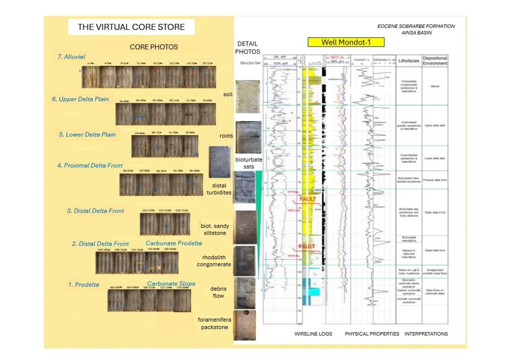
In the Aínsa Basin of the Spanish Pyrenees, the Mondot-1 well was drilled, cored, and fully logged to capture a detailed record of a long-buried ancient river delta system. Dr. John D. Marshall, Dr. Jürgen Grötsch, and Dr. Michael C. Pöppelreiter with co-workers at Shell International used this core to trace how sediments once flowed across the landscape, and were deposited under shifting tectonic conditions. The team employed augmented reality and interactive virtual displays; these innovative tools offer new ways to explore subsurface depositional systems, and are particularly useful in locations where physical access to the core is difficult, or no longer possible.
Core Insights
Cores are invaluable in examining and measuring rock properties, and essential for subsurface projects—whether for the exploration and production of hydrocarbons, water, and helium, harnessing geothermal energy, and even sequestering carbon dioxide, or storing gases like hydrogen and methane underground.
Coring behind large outcrops creates a vital link between surface geology and the subsurface. Core samples offer detailed insights into rock types, helping to uncover the structure and geological history of how those layers were originally formed. Cores also allow calibration for remote sensing data, like seismic, and wireline logs (measurements of rock characteristics taken from inside a well using special tools lowered by a cable), providing important information about the rock’s physical and chemical properties – that are impossible to determine without direct examination.
Despite its value, core sampling is expensive to carry out, and is typically limited to just a few wells. Therefore, is it crucial to connect the detailed insights gained from core data with more commonly collected datasets, like wireline logs and seismic surveys. Integrating these sources is key to building a reliable and comprehensive picture of the subsurface.
Mondot-1 Core as a Teaching Tool
The authors’ work focused on how core material from well Mondot-1 could be used as part of training programmes for subsurface professionals. They demonstrated how core data can be presented visually, allowing people to examine it from anywhere in the world – without sacrificing the detail needed for meaningful analysis.
Their research detailed how core information is used to match rock types with wireline log data, and interpret ancient depositional environments. This understanding is then used to guide how valuable resources can be found or stored underground, forming the foundation for more realistic 3D reservoir models.
Integrating Logs, Borehole Images, and Core to Map Depositional History
Standard wireline logs alone are not enough to show the finer details of how sediment was laid, or how they may have been disturbed by living creatures – this is where borehole imaging comes in. In the Mondot-1 well, a high-resolution borehole imaging tool was used (Formation Microimager FMI) to capture detailed images of the rock layers. By linking these images to the core rock samples, the team identified features like coarse gravel, disturbed sediments, and fossil-rich layers, which provided a better understanding of the delta system’s past. Their analysis was further supported by the well’s location in the Aínsa Basin of the Spanish Pyrenees—a geologically well-documented region, that serves as a valuable site for both academic study and industry-related research.
Exploring Cores Remotely: The Virtual Display Advantage
Unfortunately, only a few specialists have access to core datasets. To make this resource more widely available, several initiatives have been launched, including the creation of online libraries, where core photos and core data can be browsed and downloaded. DVD’s have also been made available. However, these formats meant the data remained largely static rather than truly interactive.
For sedimentologists, core photos and interpretations are essential, as they often integrate with fossil data in determining stratigraphy and depositional environments. Yet, when comparing data to real-world subsurface reservoirs and stores, other information is needed. Additional research may involve alignment with well logs and seismic data, laboratory analysis, as well as structural information from the core. Dipmeter and borehole imaging logs, also add essential context.
To avoid information overload, users should be able to switch and zoom between the various data types. To support learning and comparison with real-world subsurface systems, the team transformed the Mondot-1 core and wireline log data into dynamic, accessible formats.
Virtual Access to Core Data – Augmented Reality in Action
The physical display from the Mondot-1 core makes use of core slabs embedded in resin and mounted over sensors, further equipped with depth markers and core plug locations. These are combined with mobile touchscreen panels, where live data is overlaid – including well log responses, petrophysical measurements, and geological descriptions.
As users move the panel along the core, the display updates automatically, enabling adjustments to highlight specific core sections, or zooming in on the finer details. A key educational feature is that it allows users to input their own interpretations of facies, and compare them with the one from the full core description.
While the augmented reality display of the Mondot-1 well offers an innovative way to study core, it still requires users to be physically present to interact with it. To allow for a wider audience, Shell’s Digital Geology exhibition was set up using touchscreen carousels.
However, this setup relies primarily on videos, and does not allow opportunities to explore the core material. In response to the travel restrictions of the COVID-19 pandemic, a new solution was developed: a fully virtual core store. An online whiteboard was used to create this store, where core photos, core descriptions, logs, and core analyses could be displayed and easily accessed by users from all around the world.
The Mondot-1 core is brought to life through these two innovative digital teaching tools, which allow users to explore geological interpretations in a dynamic, hands-on way, even when time, cost, or safety prevent access to physical samples.
Making Core Data More Accessible Than Ever
Virtual core displays offer a number of advantages, making geological data accessible to a wider audience than ever before. These digital platforms allow users to zoom between scales—from satellite photos to electron microscope images—and enable collaboration amongst participants from multiple locations. Features like different lighting options help highlight subtle core structures, and access is no longer restricted to specific locations or hours.
However, while these virtual solutions expand accessibility and learning opportunities, they do have limitations. For instance, the core is mainly displayed in 2D, meaning users cannot access full or slabbed cores, nor identify orientation grooves, or hidden features. Resolution limitations from the core photos can also obstruct detailed study. Additionally, other senses, such as touch, cannot be brought into play.
The true potential of virtual core learning has yet to be fully explored, but insights from virtual field trip research highlight how this may be captured. With the right approach, we can begin to measure how these tools can enhance geological education and training.
SHARE
DOWNLOAD E-BOOK

REFERENCE
https://doi.org/10.33548/SCIENTIA1298
MEET THE RESEARCHERS
Dr. John D. Marshall
Development Geologist at Skrinkle Reservoir Geology
Dr John Marshall, after gaining his PhD in Sedimentology from Bristol University, worked in the oil and gas industry for over 30 years, as a development geologist, predominantly for Shell. He has worked on fields from the Northern, Central and Southern North Sea, and many others from western Europe, along with Venezuela, Oman, Syria and Australia. The work has included planning and drilling appraisal and production wells, oil and gas field development planning, feasibility scoping for enhanced oil recovery and integration with 4D seismic. In 2012, he retired from Shell and set up a small consultancy, Skrinkle Reservoir Geology, to conduct project work and training. This led to participation in a Carbon Capture and Sequestration project planned for offshore Scotland, and delivery of training courses on reservoir modelling, development geology and Carbon Storage.
CONTACT
E: marshall.skrinkle@btopenworld.com
W: https://www.researchgate.net/profile/John-Marshall-51?ev=hdr_xprf
W: https://orcid.org/0000-0002-4252-4094
in: https://www.linkedin.com/in/john-marshall-4755b19/
Dr. Jürgen Grötsch
Dr Jürgen Grötsch studied geology at the University of Erlangen-Nuremberg Germany and Scripps Institute of Oceanography USA to gain his PhD before joining Shell where he worked in both technical and managerial positions for 31 years. His special expertise is in carbonate geology, exploration and development and he worked on projects in the Philippines, Abu Dhabi, Syria, the Netherlands, the UK, Norway and Italy. He also worked as a geology training advisor where he managed Shell Training’s Digital Geology project, the initiative that resulted in the work covered in this article amongst others. After retiring from Shell he became a lecturer on Geo-Energy at the University of Erlangen-Nuremberg and founded the natural hydrogen start-up Tellus Energy Solutions GmbH. He also sits on an energy transition think tank in the Netherlands and acts as a government advisor on nuclear waste storage in Germany.
CONTACT
https://scholar.google.com/citations?hl=de&user=T5rtfKwAAAAJ

Dr. Michael Pöppelreiter
Michael Pöppelreiter studied at the Mining University of Freiberg, Germany; the Postgraduate Research Institute of Sedimentology, United Kingdom; and the University of Tubingen, Germany, where he earned a Ph.D. in 1998. Since then, he has worked as sedimentologist with Shell in Holland, as carbonate geologist/3-D modeller at Shell’s Bellaire Technology Center in Houston, USA, and carbonate team leader at the Qatar Shell Research and Technology Centre in Doha. Michael also worked in Kuwait as Chief Geologist and Carbonate Advisor. He was seconded as a professor at the South East Asia Research Laboratory in Malaysia from 2017 to 2019. Michael was subsequently chief geologist at CNPC R&D in Dubai. He has published numerous papers on carbonate reservoirs, reservoir modelling, and borehole image log technology. Michael has also been an Honorary Professor at the University of Tubingen, Germany and president of the EAGE.
Contact
W: https://orcid.org/0000-0002-4900-565X
https://www.researchgate.net/profile/Michael-Poppelreiter
FUNDING
This work was performed whilst working for Shell Global Solutions International B.V., who made the Mondot-1 well and the development of the augmented reality training display possible.
Schlumberger is acknowledged for wellsite services and wireline logging.
KEY COLLABORATORS
Students and staff from the University of Barcelona.
Philipp Wolpert from the University of Tubingen.
Lukas Becker from the Free University of Berlin.
FURTHER READING
Marshall, J.D., Grötsch, J. and Pöppelreiter, M.C. 2023 “The Mondot-1 Core, Aínsa Basin, Spanish Pyrenees: a deltaic reservoir teaching set with augmented reality” in Neal, A., Ashton, M., Williams, L. S., Dee, S. J., Dodd, T. J. H. and Marshall, J. D. (eds) 2023. Core Values: the Role of Core in Twenty-first Century Reservoir Characterization. Geological Society, London, Special Publications, 527, https://doi.org/10.1144/SP527-2022-6
REPUBLISH OUR ARTICLES
We encourage all formats of sharing and republishing of our articles. Whether you want to host on your website, publication or blog, we welcome this. Find out more
Creative Commons Licence (CC BY 4.0)
This work is licensed under a Creative Commons Attribution 4.0 International License. 
What does this mean?
Share: You can copy and redistribute the material in any medium or format
Adapt: You can change, and build upon the material for any purpose, even commercially.
Credit: You must give appropriate credit, provide a link to the license, and indicate if changes were made.
SUBSCRIBE NOW
Follow Us
MORE ARTICLES YOU MAY LIKE

Professor Hans Haubold – Professor Arak Mathai | A Summer House and the Sun: 50 Years of Space Science with the UN
From a summer house just outside of Berlin, to the establishment of educational centres across the world —Professors Hans Haubold and Arak Mathai have overseen the remarkable development of space science over the last half-century. Their early research into the curious solar neutrino problem in the 1970s spawned several books and a large volume of academic literature exploring the inner workings of our Sun.
Developments in the mathematics of fractional calculus and special functions then helped to facilitate extensive studies of space and our solar system. Over the last 30 years, under the umbrella of the United Nations, space science has boomed, with 7 new centres set up across the globe and over 20 dedicated workshops arranged. A new generation is being trained to tackle the mysteries and challenges presented to us by outer space.
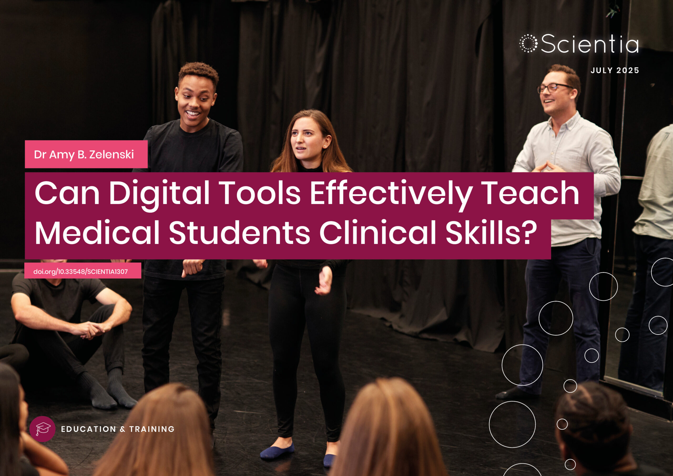
Dr Amy B. Zelenski | Can Digital Tools Effectively Teach Medical Students Clinical Skills?
Medical students often experience a decline in empathy as they progress through their training, an issue with real consequences for patient care. A new study from the University of Wisconsin explores an unexpected remedy: Zoom-based improvisational theatre. In the first randomized controlled trial of its kind, researchers found that short online improv sessions helped students improve perspective-taking, reduce emotional distress, and deeply reflect on patient relationships and power dynamics. As telemedicine becomes increasingly common, this approach to teaching empathy could offer a timely, effective, and engaging tool to help future doctors more meaningfully connect with their patients.
Dr James D. Burrington | Fuelling Hydrogen’s Role in a Net Zero Future
Hydrogen is often touted as the fuel of the future, but how much can it really contribute to global decarbonisation? Dr James D. Burrington, founder of NiceChemistry.com, has modelled how hydrogen technologies, particularly green hydrogen, might support worldwide net zero goals. His research applies rigorous metrics to assess energy efficiency, cost, emissions, and land use. This revealed that, while hydrogen may not directly replace electricity, it could be critical in decarbonising sectors where electrification falls short.

Dr Shigetaka Hayano | The Rubber Revolution: Cracking the Code for Tire Recycling!
Traditionally, rubber waste was nearly impossible to recycle due to crosslinked sulphur bonds. But a team of researchers led by Dr Shigetaka Hayano from Zeon Corporation, in Japan, have achieved a groundbreaking feat in rubber recycling. Using mild conditions for the reaction, scientists have overcome the unfavourable cross-linked structure and have achieved recovery of rubber’s original monomers. This process restores cyclopentene monomers with 90% efficiency, allowing old tires and industrial rubber waste to be chemically recycled into high quality materials. If scaled up, this innovation could revolutionise waste management, reduce environmental pollution, and enable a circular economy for rubber production.