
Dr Raymond W. Schmitt – Uncovering The Connection Between Ocean Salinity And Terrestrial Rainfall
For the first time, scientists have shown that salinity levels in the ocean’s surface can be a predictor of rainfall on land. Dr Raymond Schmitt and his colleagues at the Woods Hole Oceanographic Institution in Massachusetts used records spanning 60 years to discover this compelling relationship. They’ve successfully correlated salinity levels in two different areas of the North Atlantic with rainfall in Africa and North America, and they’re now on the hunt for other similar teleconnections.

Understanding the Global Water Cycle
If you ask physical oceanographer Dr Raymond Schmitt, he thinks our understanding of how water moves and is recycled on our planet is pretty elementary. ‘I think most people have an incorrect picture of the global water cycle,’ he says.
Dr Schmitt explains that when thinking of the water cycle, many people hark back to those over-simplified charts they first saw in grade school – the ones that show mostly land, rather than ocean, features. Indeed, if you Google ‘water cycle’ on the Internet, you’ll see that he’s right. Many images depict snow or rain falling on the tops of mountains, from where snow melts and flows into lakes and rivers or percolates into groundwater. They show water returning back to the atmosphere through evaporation from lakes, streams and oceans, as well as transpiration from plants – even trees are often drawn as huge features. But the ocean? If it is depicted at all, it’s a minor part of the figure. ‘I call it the big lie of hydrology, and it misleads many researchers so that they do not appreciate the oceanic dominance of the water cycle.’
In reality, these images should show much larger oceans, not only because of their shear size (covering 70% of the planet) but also because they are the number one source of freshwater. The evaporation from oceans is so vast, says Dr Schmitt, that the amount of water they yield (over 400,000 cubic kilometres a year) would flood the lower 48 states of the United States to a depth of around 55 metres. ‘The oceanic water cycle completely dwarfs the terrestrial water cycle,’ he emphasises.
Fortunately, flooding on this scale doesn’t happen because most of this evaporated water (90%) falls right back into the ocean. The other 10% eventually makes its way to land as rainfall. This giant water cycle and the footprints it leaves behind – specifically changes in salinity on the ocean surface – have interested Dr Schmitt for a long time. ‘If there’s a little more evaporation from a particular region of the ocean – so this area gets saltier – some of that water is going to end up on land. And so I have long wondered whether there could there be a relationship between salinity changes and rainfall on land?’
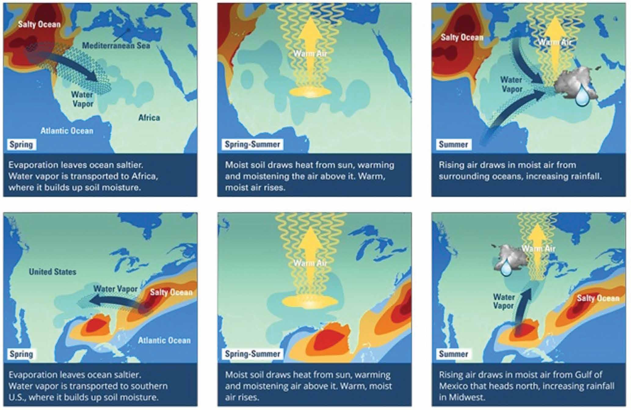
Eastern North Atlantic – Africa Sahel teleconnection
Dr Schmitt explains that he really started thinking about salinity-rainfall relationships back in 1993 after heavy rains flooded the Mississippi and Missouri Rivers in the central US. Significant amounts of water flowed into the Gulf of Mexico, creating measurably fresher seawater. For that to have happened, simple conservation of water and salt guarantees that some area of the ocean would have had to evaporate and become saltier beforehand to produce the extra rainfall on land.
‘From our studies of evaporationprecipitation patterns we know that the areas of net evaporation and net precipitation happen to be about equal. So, if say the State of South Carolina gets a foot or two of rain over a few days, I know that some comparably sized area of the ocean lost a foot or two of water from its surface,’ Dr Schmitt explains. He figured that loss would have to leave a ‘salinity signal’ large enough to show up in data from space satellites and the ‘ARGO’ array of ocean salinity monitoring buoys.
Dr Schmitt wanted to study these patterns for a long time, and finally two years ago a new post-doctoral student, Dr Laifang Li, brought new expertise on rainfall to his Woods Hole research group. ‘I gave her this problem and she really struck gold with it,’ he says.
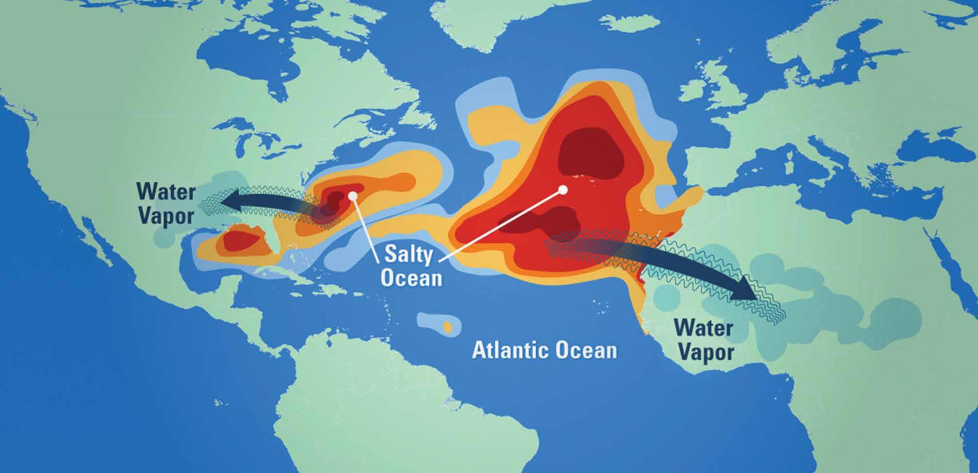
The first thing Dr Li did was to home in on an area of high salinity in the eastern part of the North Atlantic. Dr Schmitt knew where this area – the so-called salinity maximum – was located, because of a previous study that he had overseen with NASA. The project, known as SPURS (Salinity Processes in the Upper Ocean Regional Study), used data from NASA’s Aquarius satellite to map salinity patterns. Launched in 2011, Aquarius flew 657 kilometres above Earth and measured salinity in 100-kilometre wide swaths. As part of SPURS, scientists also deployed moorings and ocean robots in 2012 to verify the satellite measurements.
Using this information, Drs Schmitt and Li examined salinity variations in the eastern North Atlantic and compared it with rainfall on neighbouring continents. For a long time, Dr Schmitt expected that water evaporating from that part of the ocean was ending up in the Amazon River region of South American, but he soon discovered he was wrong. As it turns out, the water was showing up on the other side of the ocean in Africa, in a region known as the Sahel.
Along with this surprise, the researchers also observed an added twist of a 3-month delay between ocean evaporation and precipitation on land. High salinity anomalies first appear in their patch of ocean in March-April, but peak rainfall in the Sahel doesn’t occur until June-September. ‘Our first thought was that the water would get transported from ocean to land within a matter of weeks – since the winds can be pretty quick,’ says Dr Schmitt. ‘So seeing the increase in precipitation months later was a mystery.’
But Drs Li and Schmitt eventually explained the puzzle by looking at other factors. They found that in the spring, when evaporation in the ocean increases (making them saltier), water begins falling on the dry African Sahel. As moisture increases in the soil, it causes it to behave much differently than if it was dry. Effectively, the moist soil is able to absorb more energy from the sun, which causes enhanced evaporation that supplies latent heat to the atmosphere. This latent heat of the evaporating water, in turn, fuels atmospheric motion that drives convection. Convection feeds on itself and intensifies storms, which then pull in more moisture from the North Atlantic and Mediterranean during the summer.
So, the moisture in the soil is the key, and without it, you don’t have conversion of solar energy to latent heat.
‘We find that salinity in certain regions of the ocean has predictive teleconnections with rainfall in certain regions on land’
CREDIT: Eric S. Taylor/Woods Hole Oceanographic Institution
Western North Atlantic – US Midwest link
Using the same 60-year data set, Dr Schmitt’s group found another correlation. They observed that high springtime salinity anomalies in the western North Atlantic (off the US east coast) were followed by increased summer rain in the Midwestern region of the US. In addition, low salinity springs were a good predictor of summertime drought. ‘We find that salinity in certain regions of the ocean has predictive teleconnections with rainfall in certain regions on land’
As with the Sahel connection, the researchers found a similar delay, or lag time, which again they attribute to soil moisture content. In those years with enhanced spring time evaporation (and resulting high ocean salinity), rainfall and flooding begin to saturate soils in the southern US, especially in Louisiana and Texas. As the sun’s energy evaporates water from the soil, the cycle of latent heating begins and increases atmospheric convection and storms. This causes more water to be drawn from the Gulf of Mexico and into an air pattern known as the Great Plains Low Level Jet, which carries the moisture northward into the Midwest in the summer.
Dr Schmitt was so convinced of this correlation that he showed up at the American Meteorological Society meeting in Minnesota in spring of 2015 and warned them of flooding to come that summer. This was after observing a marked high salinity footprint in the spring time that same year. ‘Our prediction proved to be very accurate. They did have a rainy summer,’ he says.
The 2015 phenomena resulted in record rainfall for Texas and Oklahoma, record flooding in Illinois and the second wettest summer ever recorded in the Midwest. So much rain fell that the Great Lakes filled back up to historical levels after a long drought. The flooding also caused extensive agricultural damage and claimed 20 lives, highlighting the importance of weather awareness and predictability.
CREDIT: Eric S. Taylor/Woods Hole Oceanographic Institution
Salinity and weather predictions
In their publications, Drs Li and Schmitt make the case that salinity is a better predictor of rainfall than ocean temperature, which has been long been the standard. Temperatures on the surface of the sea can vary daily due to weather, unlike salinity, which could be a more reliable and accurate longer time signal. ‘Salinity is kind of an integrator,’ explains Dr Schmitt. ‘It’s an averaged indicator of the export of water and latent heat that’s been going on for the past few months. And latent heating is the primary means by which the ocean drives the atmosphere; the sensible heating due only to air-sea temperature differences is an order of magnitude smaller.’
Their next target research area on their agenda is the eastern Tropical Pacific, where they plan to study salinity variations in a fresher region with the SPURS project and correlate them with terrestrial rainfall in other places. They’ve already begun a year-long physical sampling program in that part of the Pacific.
Dr Schmitt is hopeful that his recent publications will attract interest from weather and climate forecasters, who may consider incorporating ocean salinity into their models. Data collection in this field is improving considerably. NASA satellites such as Aquarius and now SMAP are measuring sea surface salinities and soil moisture from space, while other systems such as the ARGO profiling floats are monitoring salinity and other variables in-situ. Meteorologists should be able to significantly improve both rainfall and drought forecasts in places such as the African Sahel and Midwestern United States if they accurately model the transfers of water from ocean to land and the role of soil moisture in the system.
Climate change, by increasing temperatures and the amount of water vapour in the atmosphere, is bound to affect the vast water cycle over the ocean. But changes and trends can be hard to measure, especially on land. ‘Wet areas should get wetter and dry areas should get drier,’ Dr Schmitt explains. ‘That’s hard to see on land because mankind has interfered with the terrestrial water cycle to a great extent.’ Examples of interruptive processes include river dams, groundwater pumping, agricultural irrigation and power plants, which cycle 40% of US freshwater.
In the ocean, however, humans aren’t able to interfere, and a clearer trend has been emerging in the last several decades. ‘Saltier areas are getting saltier, and the fresh areas are getting fresher,’ says Dr Schmitt. He explains that individual oceanographers have actually noted this pattern in various oceans for a long time. ‘The global picture was put together by some good Australian scientists a few years ago. And so we have this record of an intensifying water cycle over the ocean. There have to be impacts of that intensification on land in the form of more intense floods and longer droughts.’
The key to understanding ocean-land teleconnections are long records, which poses challenges for the science world. For one, the average length of a scientist’s career (30–40 years) compels them to do much shorter-term experiments rather than wait for a long time to analyse and publish their findings. Secondly, sustaining long-term records requires a lot of forethought and more importantly, funding, which can be inconsistent, especially in the US where politicians sceptical of climate change want to kill any related funding. Sadly, says Dr Schmitt, ‘there’s kind of a war on science going on.’
But he believes we owe it to future generations to build and maintain a global ocean observing system. In regard to long term climate change, the ocean is by far the dominant storage place for heat, water and carbon on planet Earth, and must be understood to anticipate the threats of sea level rise, floods and droughts, hurricanes, ocean acidification and fisheries collapse. But regardless of concern about climate change, the future financial return to society on modest investments in ocean monitoring is enormous, he says. ‘The more we know about the climate system the better we will be at predicting its’ future state.’ The practical advantages of improved seasonal rainfall forecasts for farmers, water and emergency managers, and society in general are obviously substantial.
Meet the researcher
Dr Raymond W. Schmitt
Woods Hole Oceanographic Institution
Woods Hole, Massachusetts, USA
Dr Raymond Schmitt is a Senior Scientist and Physical Oceanographer at the Woods Hole Oceanographic Institution in Massachusetts. He received his PhD in Physical Oceanography at the University of Rhode Island after obtaining his BSc in Physics at the Carnegie Mellon University in Pennsylvania. His early work on the small-scale doublediffusive mixing phenomena of ‘salt fingers’ led him to his later interest in the water cycle and global salinity patterns. In 1997 Dr Schmitt was named as a J. S. Guggenheim Fellow and in 2012 became a Fellow of the American Geophysical Union and was appointed to the Van Allen Clark Sr. Chair for Excellence in Oceanography. Dr Schmitt has published or co-authored over a hundred papers, and continues to research a range of oceanographic topics, including the global water cycle and oceanic mixing. He also advocates for improving and sustaining a global ocean observing system. He participated in the National Research Council’s panel on ‘America’s Climate Choices’ and contributed to the report, ‘Advancing the Science of Climate Change’. He has served on numerous advisory boards, currently including the Earth Science Subcommittee of the NASA Advisory Council.
CONTACT
T: (+1) 508 289 2426
W: http://www.whoi.edu/profile.do?id=rschmitt
KEY COLLABORATORS
Dr Laifang Li, Woods Hole Oceanographic Institution
Dr Caroline C. Ummenhofer, Woods Hole Oceanographic Institution
Dr Kristopher B. Karnauskas, University of Colorado, Boulder
FUNDING
National Science Foundation
National Aeronautics and Space Administration
ADDITIONAL READING
L Li, RW Schmitt, CC Ummenhofer, KB Karnauskas, North Atlantic salinity as a predictor of Sahel rainfall, Science Advances, 2016, 2, e1501588.
L Li, RW Schmitt, CC Ummenhofer, KB Karnauskas, Implications of North Atlantic Sea Surface Salinity for Summer Precipitation over the US Midwest: Mechanisms and Predictive Value, Journal of Climate, 2016, 29, 3143–3159.
RW Schmitt, Double diffusion in oceanography, Annual Review of Fluid Mechanics, 1994, 26, 255–285. RW Schmitt, The ocean component of the global water cycle, Reviews of Geophysics, 1995, 33, 1395–1409.
C Wunsch, RW Schmitt, DJ Baker, Climate change as an intergenerational problem, Proceedings of the National Academy of Sciences, 2013, 110, 4435–4436.

DOWNLOAD