
Dr Gabriel Wolken – Harnessing Citizen Science to Collect a Blizzard of Data
Alongside his collaborators, Dr Gabriel Wolken of the University of Alaska Fairbanks and the Alaska Division of Geological & Geophysical Surveys has pioneered citizen science to collect data on snowfields in the largest state of the USA. As rising global temperatures are altering snowfall and melting patterns, such critical data will enable scientists to understand the broad effects of these changes in mountainous areas, potentially allowing us to mitigate damaging impacts on people and wildlife.
CREDIT: Ryan Crumley
Changing Snowscapes
Few things are as beautiful as a towering mountain range, rugged slopes climbing to dizzying heights where snow-capped peaks nestle amongst wind-whipped clouds. Yet one of the key components of this image, snow, is increasingly under threat. Global temperatures are steadily rising due to our greenhouse gas emissions, playing havoc with the regular snowfalls and melting patterns of former times.
These disruptions are a serious concern, as snow is a vital part of the regional ecology in many parts of the world. Deposited in thick sheets during winter, snow gradually melts over the spring and summer and feeds the glaciers, rivers, streams and lakes of the surrounding area. Gradual melting supplements rainfall, providing a consistent source of water for local plants, animals, people, and the resources upon which people depend.
Rising global temperatures bring with them less snow cover, reduced snow depth, and shorter, warmer winters. This means less snow in the mountains and faster melting once spring begins, which leads to a rapid pulse of water careening down the streams and rivers instead of a consistent trickle. In some areas, this makes for long summer months without water – a dangerous situation for wildlife, farmers, fisheries and communities that depend on hydropower.
Despite its importance, understanding the melting process is a challenge for scientists. The melting process is based on a number of interacting variables that are difficult to model. Snow may be deeply packed in one area, exposed to harsh winds and reduced in another, or even hidden in a dark, cool crevasse and preserved in a third. In order to make accurate predictions, allowing policy makers to make effective decisions when it comes to mitigating the impacts of future warming, scientists need accurate data of the entire snowpack in a given region. Satellite imaging, radar returns and measuring differences in local gravity have been used to assess snowpack – all of these methods provide usable data, but each has its own limitations.
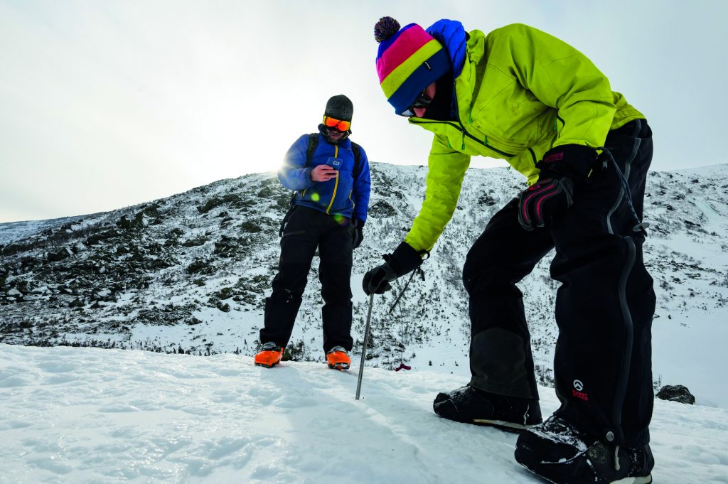
One of the most basic ways to measure snow depth is, well, to poke it with a stick and see how deep it is. This direct measurement of the snowpack provides very accurate data, free from the inferences that need to be made when interpreting satellite or fly-by data. However, there are only so many climate scientists, a lot of snow to be measured, and very few reliable roads to get around. ‘Monitoring snow in the mountains is very difficult, because the amount of snow can change considerably over short distances, while the rough terrain makes access difficult,’ says Dr Gabriel Wolken of the University of Alaska Fairbanks and the Alaska Division of Geological & Geophysical Surveys.
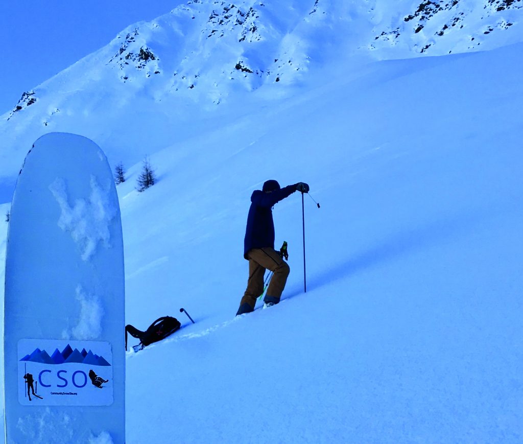
To solve this problem, Dr Wolken and his colleagues turned to crowd-sourced observations and a team of citizen scientists, in a project known as Community Snow Observations, or CSO.
‘Submissions by citizen scientists have dramatically reduced snow distribution model error, which greatly improves our ability to estimate the amount of snow in the areas that are being modelled.’
CREDIT: Joe Klementovich
A Snow-Loving Crowd
Alaska is full of towering mountains, snowy fields, and pristine forests. All of these combine to make it a winter paradise, and many Alaskans spend the cold months cruising around on skis or snowmobiles, often venturing out into isolated back-country areas.
These enthusiasts represent a fantastic resource for time-strapped climate researchers – they travel long distances, reach very high elevations and are naturally quite interested in continuing their favourite hobby. This takes them directly into the areas of the snowfields where data is scarce. It is perhaps no surprise that Dr Wolken and his collaborators saw them as natural partners in their research, a body of ‘citizen scientists’ – those who may not have formal training in the field but who are interested in taking part in the research process.
The idea of recruiting local volunteers for this purpose came from an earlier set of measurements performed from an aeroplane. Dr Wolken had asked a number of back-country enthusiasts to cross-check the results they had obtained, and so many skiers and snowmobile drivers spent the day travelling in every direction, measuring snow depth and recording their location using GPS. ‘We ended up getting so many more measurements than we could with just a science team,’ says Dr Wolken. If this was possible in just one day, he and his colleagues reasoned, what could be done with a more permanent and holistic approach? To answer this question, Dr Wolken and his colleagues successfully applied for funding from NASA.
No method is perfect, of course, and citizen science research has some extra difficulties involved. The choice of routes taken and sample locations is naturally up to the volunteers themselves, which means that some locations may be poorly covered. There is also the challenge of training people to take accurate measurements – what seems easy in a YouTube video is a lot harder out on the freezing mountaintop.
To avoid these problems, Dr Wolken and his colleagues decided to develop a simple, rapid method for making observations, as part of their Community Snow Observations program. They focused on snow depth and set out to make the process of reporting data as easy as possible. This was achieved by partnering with the developers of Mountain Hub, a community-focused app which brings live updates from outdoor enthusiasts together into one central location. Available for free on both Apple and Android smartphones, this app provides maps of back-country areas and allows users to upload information about trail conditions. In collaboration with Dr Wolken, the Mountain Hub group included the ability for app users to provide snow depth information.
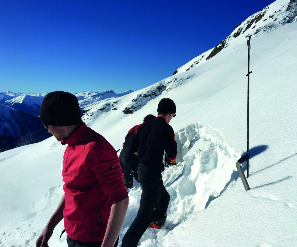
How does this work? Most back-country snow-goers carry an avalanche probe – a long, foldable pole which allows you find buried people in the loosely-packed snow following an avalanche. The volunteers take three measurements within a one-metre circle, calculate the average, and then enter this information into the Mountain Hub app. The app automatically includes their location and these data are sent in to a central server as soon as a wireless connection is established.
Drifting Back to Reality
This all sounds rather clever, but does it actually work? Yes, and quite well. Initial tests were performed using volunteer measurements from the Thomson Pass region near Valdez, Alaska. The pass is the snowiest area in Alaska, and a popular location for skiers, snowboarders, and back-country enthusiasts. Over the course of 2017, citizen scientists performed a number of depth measurements at widely-scattered locations across the snowfield. They then uploaded the data using the Mountain Hub app.
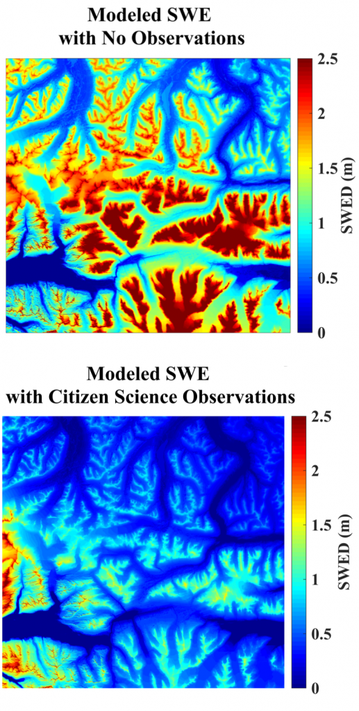
Dr Wolken and his colleagues then incorporated the snow depth data into a mathematical model to simulate the snowpack. This model uses climate data to create an estimate of the overall depth of snow and the ‘snow water equivalence’, which is essentially the amount of water you would get if all of the snow melted at once.
As Dr Wolken explains: ‘The model performs very poorly in mountainous areas that lack well distributed, continuous observations from weather stations.’ This is where the community observations came in useful. By using the collected snow depth values as ‘anchor points’, the team was able to merge the calculated depth values of the model and the actual measured values from the volunteers. This provided a reference point for the computer simulation, dramatically reducing the amount of error in the numbers it spits out. This allows the researchers to make far more accurate predictions about the behaviour of the snowfield than they could without the help of the volunteers.
‘Essentially, when a new snow measurement is submitted, the difference between the model-predicted depth and the measured depth is used to steer the model back towards reality,’ explains Dr Wolken. ‘Submissions by citizen scientists have dramatically reduced snow distribution model error, which greatly improves our ability to estimate the amount of snow in the areas that are being modelled.’
The Future
For their next steps, the researchers hope to recruit even more citizen scientists into the measurement process. The number of new measurements each year is naturally dependent on the number and enthusiasm of the volunteers themselves. However, early signs are promising, as the researchers report that they now have thousands of measurements from across North America.
The Mountain Hub app is used by outdoor-lovers across the globe and so allows snow depths to be registered anywhere in the world. The community has taken up this challenge, and the researchers have reported hundreds of data points coming in from such far-flung locations as Kazakhstan, Iceland, Antarctica, Hawaii and Svalbard near the North Pole.
The next step is to improve the overall community outreach, in particular trying to show volunteers just how their measurements are being used. To do this, Dr Wolken and his colleagues have made their data available to anyone, free of charge. Beyond this, Dr Wolken and his colleagues intend to expand the incentives for the citizen scientists. Although helping the project is voluntary, few people complain when they receive extra recognition or a few goodies. Thus, the scientists have begun to recognise consistent helpers as ‘ambassadors’, as well as organising free giveaways of snow-related equipment.
The Community Snow Observations program has already shown its worth within just a few years of operating. The additional data gathered by the volunteers allows the researchers to more accurately model the snowpack and its eventual melting. Thanks to the efforts of Dr Wolken and his team, we now have the chance to understand how snow distribution might change with continued changes in climate, and the resulting impacts on hydrological systems, glaciers, ecosystems, and hazards such as avalanches.
Reference
https://doi.org/10.33548/SCIENTIA379
Meet the researcher
Dr Gabriel Wolken
Division of Geological and Geophysical Surveys
Alaska Department of Natural Resources
Alaska Climate Adaptation Science Center
University of Alaska Fairbanks
Fairbanks, AK
USA
Dr Gabriel Wolken was awarded his PhD in Earth and Atmospheric Sciences from the University of Alberta in Canada. He currently holds a joint appointment as the manager of the Climate and Cryosphere Hazards Program at the Alaska Division of Geological & Geophysical Surveys, and a research professor with the Alaska Climate Adaptation Science Center at the University of Alaska Fairbanks. His work revolves around changes in snow and ice, particularly in the high mountains or polar latitudes. Over the course of his career, he has authored numerous papers, reports and data products, and is a regular invited contributor for governmental climate reports.
CONTACT
E: gabriel.wolken@alaska.gov
W: http://dggs.alaska.gov/pubs/staff/gjwolken
W: communitysnowobs.org
KEY COLLABORATORS
Dr Anthony Arendt, University of Washington
Dr David Hill, Oregon State University
Katreen Wikstrom Jones, Alaska Division of Geological & Geophysical Surveys
Ryan Crumley, Oregon State University
FUNDING
NASA Citizen Science Grant (CSESP16-0003)
![]()
Creative Commons Licence
(CC BY 4.0)
This work is licensed under a Creative Commons Attribution 4.0 International License. 
What does this mean?
Share: You can copy and redistribute the material in any medium or format
Adapt: You can change, and build upon the material for any purpose, even commercially.
Credit: You must give appropriate credit, provide a link to the license, and indicate if changes were made.
More articles you may like
Professor Neil Coffee – Professor Vincent Versace | Mapping Health Access: Using Address-Level Intelligence for Smarter Services
Accessing healthcare is a serious challenge for people living in rural and remote Australia. Large distances, sparse populations, and limited services can prevent residents from receiving care when they need it. Professors Neil Coffee and Vincent Versace at Deakin University’s Centre for Australian Research into Access (CARA) are leading research to model healthcare service access across the country, to provide new insights that can guide health planning and policy, as well as other services such as education. This work combines the curation of detailed address level residential dwellings and road network data to calculate access to service metrics (time and distance). These metrics are applied to the simulated residential dwelling population, to quantify the population with poor access to health services.

Prof Candis M. Morello – Prof Jan D. Hirsch | Recent innovations in pharmacy education
A pioneering research team from the Skaggs School of Pharmacy and Pharmaceutical Sciences, University of California, San Diego, United States, has been instrumental in developing innovative techniques for teaching pharmacy students. The Next Generation of Pharmacist Educators (NextGen-RxEd) programme is a new method of training the next generation of pharmacist educators and academics. To help pharmacists and pharmacy students visualise the complex issues experienced by their patients, the team led by Professors Candis Morello and Jan Hirsch developed an innovative educational tool, called the Medication Therapy Management (MTM) Spider Web.

Professor Michael Yarus | How RNA Started the Conversation That Built Life
The genetic code stores the instructions for building proteins, yet how it first arose remains unclear. It likely did not appear fully formed, but instead emerged step by step from simple chemical interactions. In this study, a team led by Professor Michael Yarus at the University of Colorado Boulder shows how early ribonucleic acid (RNA) molecules could bind specific amino acids, creating the first coding relationships. These early interactions are then refined through evolutionary processes such as duplication and merging of partial codes. By combining the experimental data with computer simulations, the work provides a testable pathway from prebiotic chemistry to the modern genetic code.

Identifying Nutritional Risk in Early Childhood: Insights from NutriSTEP®
Early childhood is a critical period for growth and development, yet many young children face nutritionrelated risks that can go unnoticed. Professor Janis Randall Simpson and colleagues have developed NutriSTEP®, validated and reliable screening tools that help identify potential nutritional concerns in toddlers and preschoolers. Their large-scale analysis of Canadian data reveals patterns in diet, behaviour, and food access that could help guide early interventions and support healthy development.