
Dr Gerald Gabriel Dr Thomas Burschil – What Seismic Imaging Tells Us About The Mysteries Of The Tannwald Basin
What is seismic imaging?
If you’re not familiar with geological processes or their imaging techniques, then you may not have come across seismic surveying. For anyone who wants to understand the research concept, it is essential to understand the basics.
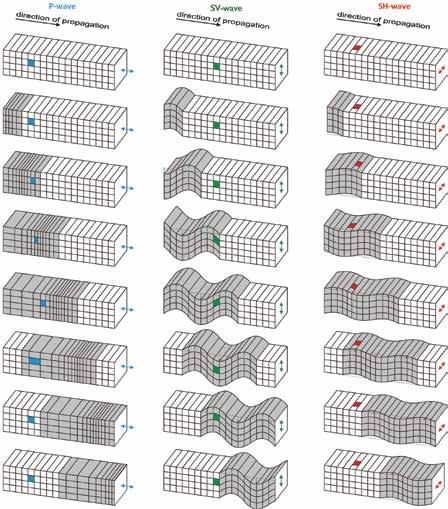
So what is seismic imaging? Seismic imaging can be carried out in 2-D and 3-D, and utilises different types of elastic waves – the Primary (P) wave or Secondary (S) wave. P-waves are compressional longitudinal waves which penetrate through subsurface layers, causing the Earth to compress and stretch along the axis of propagation of the wave in a similar fashion to sound waves. S-waves are shear waves which cause the ground to move perpendicular to the direction of propagation so that they can be separated into a vertical mode (SV) and a horizontal mode (SH). In general, S-waves are harder to receive for different reasons. They penetrate through the Earth much slower than P-waves do, and often image only the shallower part of the geological structure. Furthermore, they often interfere with surface waves (or ground roll) that cause a strong movement of the Earth’s surface and, hence, cannot be detected easily. However, S-waves can provide geologists with a means of imaging shallow structures at a high resolution. Both types of waves produce different but complimentary data, and modern approaches in seismic imaging utilise both types of waves to build an image of structures beneath the Earth’s surface.
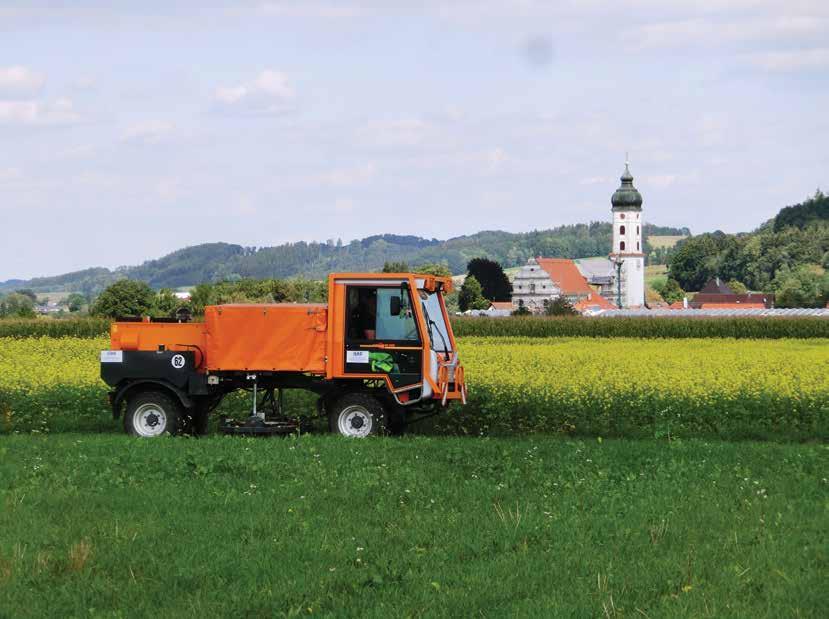
This is a major focus of the research carried out at the Leibniz Institute for Applied Geophysics (LIAG) in Hannover, Germany. Drs Gerald Gabriel and Thomas Burschil, along with their colleagues at LIAG, have developed a more sophisticated technique that employs horizontally polarized S-wave vibrations. This technique offers a greater ability to investigate structures at shallow depths and provide often a much higher resolution. The seismic waves are produced by a specially designed vibrator that excites elastic waves that propagate through the upper some hundred meters of the Earth’s crust and are then recorded by receivers, or so-called geophones. Afterwards, signals of reflections in the subsurface can be processed into a seismic image of the structures.
Download
Share
What is the Tannwald Basin? And why is it of geological interest?
The Tannwald Basin is an example of an ‘overdeepened basin’, located in the state Baden-Württemberg in Germany, and hence in the foreland of the Alpine mountain range. The Tannwald Basin is a pilot region that is used to study overdeepened valleys and to transfer and link the results of the research to other more populous regions. Understanding the structures located here is of geological and environmental importance, and also of social relevance. In fact, this was one of Dr Gabriel’s motivations to study this particular region: ‘For me, the social relevance of these overdeepened valleys is attractive because I feel that we can serve society with our research’. The basin is part of a larger system of overdeepened valleys which are present across the entire Alpine region. The Tannwald Basin is one the many ‘branch’ basins that surround the core basin of the Rhine glacier, which formed, e.g. Lake Constance. With respect to the geological time scale, these basins were formed over a short period of time by glacial activities, and at least three occurrences of strong glacial activity are known to have happened in this region.
Overdeepened basins are located in regions that have been affected by glacial activity at some point in the Earth’s evolution. The term ‘overdeepened’ is a reference to the genesis of valleys and basins; they were presumably formed by pressurised, subglacial meltwater. As a result of glaciations, the overdeepened valleys elongated in the direction of the glacial flow. When the glaciers retreated, many of these valleys were quickly filled by various sediments and became buried. However, it is assumed that repeat glaciation events have caused major parts of the sediments, even all sediments, to be removed, leading to a complex infill pattern. Current information about structures within these basins has often been derived from drilling local boreholes and obtaining geophysical data. However, for the Tannwald basin, only a small amount of previous data is available, and this does not compare to the data that can be obtained using modern approaches. Furthermore, a borehole is only relevant to the local structures that surround it, and may not be an accurate representation of the entire basin. Research up to this point has not answered the vital questions required in order to use the valleys as groundwater sources and to understand the hazard potential associated with these valleys. By investigating the geophysical and geological data of the entire Alpine region, the climatic history can be deciphered and future scenarios can be developed. One way of answering these questions could be to embark upon a comprehensive drilling project. However, drilling multiple boreholes is a large undertaking, so by providing a complex and accurate seismic survey of the area allows precautions to be taken and to determine where the drilling of the borehole should take place.

Applying seismic imaging to the Tannwald Basin
Although there are many techniques that can be applied to analyse basins, seismic imaging is most commonly employed because it gives the most detailed images of sedimentary layers. Other methods used in the past could only reveal the outlines of large geological structures, or could not penetrate the structures clearly to show the finer structures that can be seen using P- and S-wave reflection seismic techniques. However, conventional reflection seismic imaging techniques generally investigate a deeper domain than the depth of the basin. Dr Burschil tells Scientia about the technique they employ in order to image overdeepened basins: ‘We apply multi-component reflection seismic techniques, using 3-component receivers and two different orientations of S-wave sources to investigate Quaternary sediments’. Implementing this new way of imaging by applying a multi-component method, marks a milestone within this field of research, allowing for more detailed images of many subsurface structures to be produced.
During the seismic surveys, Drs Gabriel and Burschil use different types of seismic waves to build a clearer picture of the structures of the valley. So far, five P-wave, two SH-wave and one multicomponent reflection seismic profiles have been acquired to investigate the sediment succession in detail. Cross-lines have also been recorded to study the 3-D effects and to test to see if a 3-D multi-component analysis is a feasible approach.
Both the observed P-wave and SH-wave profiles are of very high quality and exhibit the similar structures. The P-waves have strong reflections at the base (top Molasse) of the basin, consistent with the data collected from a borehole in the 1990s. The depth of the Tannwald Basin ranges between 80 and 240 m, depending on the location. P-waves also show partial incoherent reflections below the top Molasse, and the sedimentary infill displays segments of faint reflection signals which are partially connected to each other. However, the SH-waves provide more structural detail with higher resolution than the P-waves, but image fewer geological structures in comparison.
The area of the examined basin can be classified into two main regions – the western part and the eastern part. Below the base of the basin, the reflections were found to be brighter in the P-wave profiles than the SH-wave profiles, whereas shear waves lack penetration power. Parts of the basin infill are better resolved by S-waves, while for others, P-waves are the most suitable option. The combination of the two gives the best results. Further analysis of the multi-component data will give new information about anisotropy of the deposits due to the glacial overprint and tectonics.
The analysis of the seismic data is major step forward for a new proposal under the umbrella of the International Continental Scientific Drilling Program (ICDP) called DOVE (Drilling Overdeepened Alpine Valleys). The new data obtained from the geophysical survey combined with the previous borehole studies have allowed a new borehole drill site to be chosen for the Tannwald Basin; further complementary borehole sites are suggested for other regions in the Alps. As part of this ICDP proposal, existing data will be reinterpreted against the background of geophysical characteristics, by combining the seismic data with the results of the drilling activities. The new findings from the Tannwald Basin may also suggest additional target-orientated pre-site surveys elsewhere. The advances in the methodology and hypotheses derived from this project will then be applied to other overdeepened structures in the Alps. Combining the multiple data sets from all investigation sites will allow for a clearer picture to be built of the Quaternary sedimentation and deposition changes over the entire Alpine region.
‘I demonstrated that by moving points in space as exact differentials with source terms, no artificial physics needed to be introduced for time dependent problems’
What to expect in the future
Analysis and interpretation of the seismic data acquired at the Tannwald basin is to be explored further. In addition to the analysis of this site, there are plans to use seismic imaging at a secondary location (Lienz Basin, Austria) as well as potentially introducing 3-D, multi-component analysis into the seismic surveying.
A key test will be to start drilling cored boreholes within the basin to enhance and broaden the scientific approach and to confirm the seismic interpretation. One of Drs Gabriel and Burschil’s aims is to gather a team of interdisciplinary scientists to analyse the core material using various methods, in order to date the sediments as well as analyse their physical properties. These future investigations will provide information about the glaciational and depositional environments in southwest Germany. In addition, the anisotropic physical properties of the rocks can be determined.
Meet the researchers

Senior Scientist Leibniz Institute for Applied Geophysics
Hannover,
Germany

Postdoctoral Scientist Leibniz Institute for Applied Geophysics
Hannover,
Germany
Dr Gerald Gabriel is a senior scientist at the Leibniz Institute for Applied Geophysics in Hannover, Germany. He obtained his PhD at the University of Clausthal, Germany, with a project investigating the geodynamic evolution of the Harz Mountains. Following this, he began postdoctoral work at the Leibniz Institute for Applied Geosciences, where he currently holds a senior research position working in the areas of section seismics, gravimetry, and magnetics. He is also an Associate Editor for Near Surface Geophysics.
Dr Thomas Burschil is a research scientist, also working at the Leibniz Institute for Applied Geophysics. After obtaining his degree in Physics, he started his career by working as a project scientist on the EU Interreg project CLIWAT. Following this, he went on to achieve a PhD in Geophysics at the Technical University of Berlin, with a thesis titled ‘Geophysical characterization of the Föhr island groundwater system’. At the Leibniz Institute for Applied Geophysics, he currently works on multi-component seismics in overdeepened Alpine valleys and basins.
The Leibniz Institute for Applied Geophysics (LIAG) in Hannover, Germany conducts research in the field of physical geosciences to meet the future needs of society. Researchers at the institute investigate the uppermost part of the Earth’s crust which is accessible for economic use and of primary importance for the supply of essential resources. The institute consists of 90 employees from various backgrounds and covering many disciplines, and has strong research focus on the fields of groundwater systems, geothermal energy and terrestrial sediment systems. The institute is member of the Leibniz Association.
CONTACT
E: gerald.gabriel@liag-hannover.de
E: thomas.burschil@liag-hannover.de
T: (+49) 511 643 2302
W: www.liag-hannover.de/en/home.html
KEY COLLABORATORS
Prof. Charlotte Krawczyk, GFZ German Research Centre for Geosciences, Potsdam, Germany
Dr Cedric Schmelzbach, ETH Zürich, Switzerland
Prof. Markus Fiebig, University of Natural Resources and Life Sciences (BOKU), Vienna, Austria
Dr Jürgen Reitner, Geologische Bundesanstalt, Vienna, Austria
Dr Paul Herbst, GWU Geologie-Wasser-Umwelt, Salzburg, Austria
Dr Ulrike Wielandt-Schuster, Dr Dietrich Ellwanger, Landesamt für Geologie, Rohstoffe und Bergbau im Regierungspräsidium Freiburg, Germany
Prof. Flavio Anselmetti, University of Bern, Switzerland
Prof. Frank Preusser, Albert-Ludwigs-Universität Freiburg, Germany
Dr Miloš Bavec, Geological Survey of Slovenia, Ljubljana, Slovenia
Dr Christian Crouzet, Université de Savoie Mont Blanc, Chambéry, France
Cesare Ravazzi, Institute for the Dynamics of the Environmental Processes, Milan, Italy
FUNDING SOURCES FOR LIAG PROJECTS (not complete)
Deutsche Forschungsgemeinschaft (German Research Foundation)
International Continental Scientific Drilling Programme
European Union
INTEREEG
Bundesministerium für Bildung und Forschung
Bundesministerium für Wirtschaft und Energie
Bundesministerium für Verteidigung
Industry Partners (scientific cooperation)
Norwegian Research Council Earthquake Commission New Zealand
REFERENCES
Buness H., Gabriel G., and Ellwanger D., Quaternary Science Journal (Eiszeitalter und Gegenwart), 2008, 57, 338–366.
Burschil T., Scheer W., Kirsch R., and Wiederhold H., Hydrology and Earth System Sciences, 2012, 16, 3485–3498.
Gabriel G., Ellwanger D., Hoselmann C., Weidenfeller M., and Wielandt- Schuster U., Quaternary International, 2013, 292, 43–58.
Gabriel G., Kirsch R., Siemon B., and Wiederhold H., Journal of Applied Geophysics, 2003, 53, 159–180.
Krawczyk C.M., Polom U., and Beilecke T., The Leading Edge, 2013, 32, 256–263.

