
Dr John Barnes – Monitoring Atmospheric Pollution with Laser Imaging
Lidar (Light Detection and Ranging) is a laser-based remote sensing tool that can measure the concentration of small particles, called aerosols, in the atmosphere. Monitoring aerosols is crucial for climate modelling, air quality measurements, and understanding the health impacts of atmospheric pollution. However, existing lidar systems require sophisticated and expensive equipment and are usually deployed by research technicians. They also have trouble measuring atmospheric pollutants near the ground, where they impact human health. Scientist Dr John Barnes at NOAA in Boulder, Colorado, and his colleagues have developed an inexpensive and straightforward commercial lidar solution using widely available camera and optical equipment.
Measuring Air Quality
Aerosols are tiny solid particles or liquid droplets suspended in the atmosphere. When the particles are large enough, they scatter and absorb sunlight. Aerosols are the cause of atmospheric haze, which reduces visibility. They also give sunrises and sunsets their eye-catching red colours.
Aerosols can be natural, including sea salt, dust, pollen and ash from volcanic eruptions, or released by human activity, such as factory and vehicle emissions. Mainly concentrated in the lowest few kilometres of the atmosphere, aerosols can be extremely damaging to human health. Polluting aerosol emissions have been linked to increased rates of heart disease, lung disease and asthma, in addition to a range of other conditions.
Because aerosols scatter the sun’s rays and interact with other chemicals in the atmosphere, they can also profoundly impact local weather systems and climate. Their effect on visibility also affects aircraft safety. Understanding and mitigating this broad range of aerosol impacts requires the ability to monitor them over both time and space.
Scientists can map aerosols as a function of altitude using lidar technology. With this method, a pulsed laser transmits light into the atmosphere. A detector then measures the amount of laser light scattered in its direction by air molecules, clouds, and aerosols. The sensor uses the intensity of the scattered light signal to measure aerosol concentration.
Lidar also determines the altitude of the aerosols it measures. In most lidar systems, the laser and detector are placed at the same location. The detector measures height in the atmosphere using the timing of the light returned from the scattered particles. This method requires expensive timing detection hardware and a pulsed laser. These systems also have difficulty measuring near the ground, where aerosols can significantly impact human health.
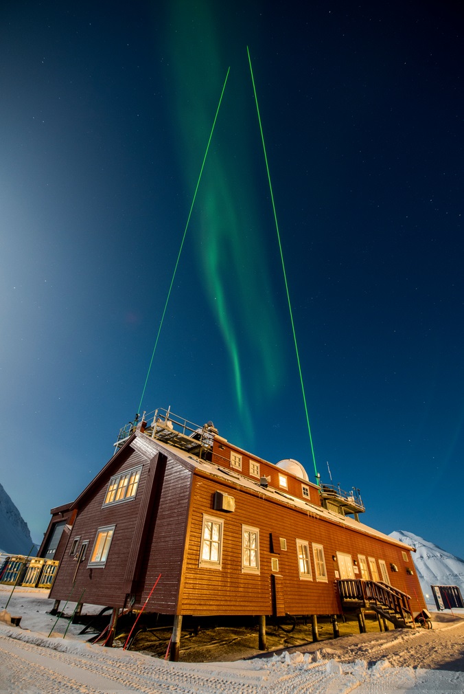
To address these challenges, Dr John Barnes and his colleagues have been developing more effective and inexpensive instruments for sensing atmospheric aerosols. One technique, called Camera Lidar – or ‘CLidar’ – involves transmitting a laser beam vertically into the atmosphere. A camera with a wide-angle lens positioned a few hundred metres away then captures images of the laser beam to measure aerosols. Another of Dr Barnes’ inventions, the imaging polar nephelometer, can measure the size and shape of the aerosols.
His team’s new techniques are based on inexpensive and widely available components, making the technology more accessible to educators and scientists in developing countries, for whom the high cost of traditional lidar systems could be prohibitive. Dr Barnes and his collaborators are currently working hard to improve their instruments and make them available to scientists worldwide.
CREDIT: Gregory Tran, PIXOPHIL.
Building a Camera Lidar
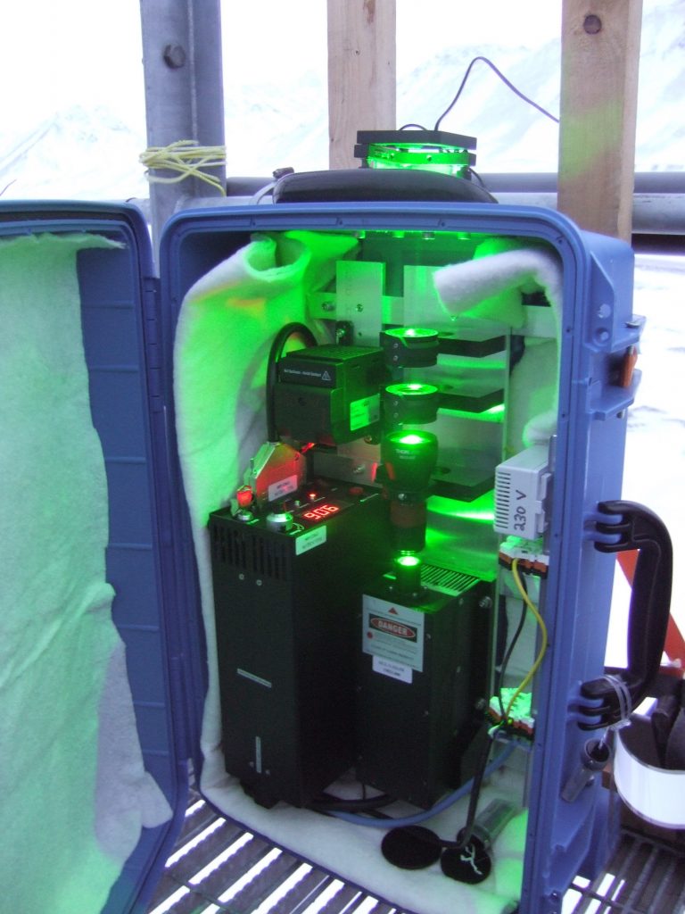
The team’s CLidar system consists of a laser beam transmitted vertically upwards into the atmosphere. A continuous wave laser can be used, which is less expensive than the pulsed laser needed for lidar. A camera, with a filter and a wide-angle fisheye lens, positioned a few hundred metres away, serves as a detector. The camera images the entire laser beam, from the ground to its zenith. The laser beam intensity in each pixel of the camera image provides information on light scattering by aerosols: brighter portions of the laser beam indicate more aerosols.
To construct a CLidar system, air quality scientists need only a few simple components. Along with the laser, they need a camera with a wide-angle lens, which is necessary to capture the whole laser beam at once. The camera is controlled by a computer through a USB connection and can be networked for remote control. ‘The camera lidar technique is much simpler than a regular lidar,’ says Dr Barnes.
Unlike traditional lidar, the CLidar system doesn’t need to measure height in the atmosphere using expensive hardware to time the arrival of light at the detector. As the camera is stationed at a distance from the laser the angle between the camera and the beam can be calculated using simple geometry. Using this method, a scientist can calculate the height at each point along the beam.
Aligning the camera lidar simply means getting the beam in the image away from the edges. To analyse the image, a user must separate the scattering of light by aerosol particles from the background scattering by air molecules, which varies by altitude. Separating the signals means calibrating the system by taking measurements in a clear, aerosol-free region of the sky, usually several kilometres in altitude. This region must also be free of clouds, as water vapour interferes with the measurements.
Prototype laser optics box deployed at Ny Alesund.
The team’s technology can provide accurate and detailed measurements near the ground, which is vital for measuring sources of pollution originating close to the surface. The new system can also produce an aerosol profile every minute. Multiple consecutive images can allow researchers to study atmospheric dynamics. For example, Dr Barnes and his colleagues took the instrument to coastal Hawaii to observe aerosol injection from waves breaking on the seashore.
As it relies on taking pictures of light from a laser beam aimed skyward, the process requires darkness and can only be used at night. However, the team has plans to modify the instrument to use an infrared camera and laser, allowing daytime operation. The camera and laser need to be positioned to avoid interference from buildings and streetlights. Dr Barnes also recommends angling the camera away from the moon; in the Northern Hemisphere, it should be pointed north.
Dr Barnes recently travelled somewhere suitably isolated to test their CLidar system under more difficult conditions. Ny-Ålesund, a remote research station on the Norwegian island of Svalbard, is the world’s northernmost settlement. In the freezing Arctic night, with temperatures from −3 to −22°C, he set up and operated a prototype laser and camera.
The instrument performed well under challenging conditions, allowing his research team to gather 152 hours of data. The CLidar produced detailed low-level data, which revealed more aerosols at about 60 metres height compared to ground level. This pattern was unexpected, but could be explained by cold, clean air flowing down glaciers and displacing the air at the surface.
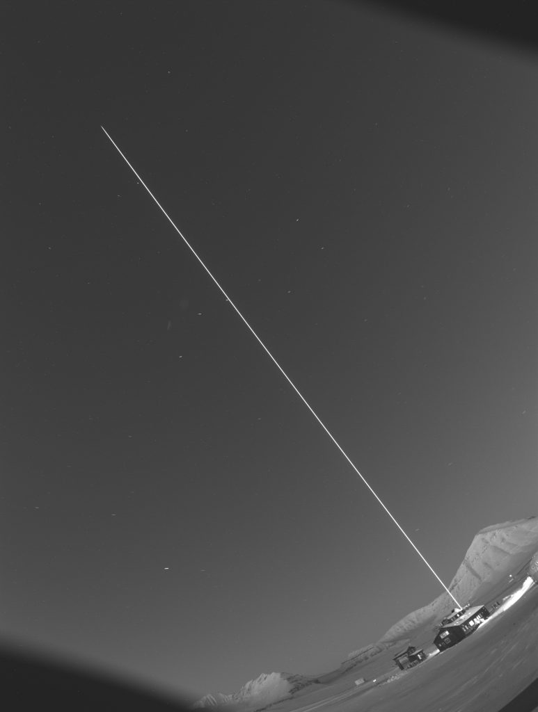
Data file that was analysed to achieve an aerosol profile
Measuring Aerosol Properties
So far, the team has published more research on their CLidar system, but they also have high hopes for the potential of a related invention, called an imaging polar nephelometer or IPN. The word ‘polar’ refers to a mathematical polar plot of radius and angle. ‘I think both instruments have equal potential,’ says Dr Barnes.
Although aerosols scatter light in every direction, lidars and camera lidars only measure light scattered along a single path: the angle between the laser beam and the camera. To convert this single-angle data into more valuable quantities such as visibility and aerosol concentration, scientists use mathematical functions. The functions rely on knowledge of the size, shape and composition of the aerosol particles. However, very few scientists measure these aerosol properties, meaning that such equations are among the most significant sources of error in lidar measurements.
Dr Barnes invented the IPN to solve this problem. This device uses the same simple components as the CLidar system: a camera, wide-angle lens, and a laser beam to measure aerosols. This is not a remote sensing measurement, like the camera lidar, but draws the air into the IPN located near the ground or on an aircraft. The IPN measures scattered light at multiple angles which vary greatly for aerosols. While the CLidar system measures aerosol concentrations, the IPN can give more detailed information about the aerosols’ size, shape, and composition.
Air quality scientists classify particles by size according to their health impacts: smaller particles can penetrate further into the lungs. Using the IPN, they can measure the concentrations of specific particle size classes that are particularly hazardous to human health.
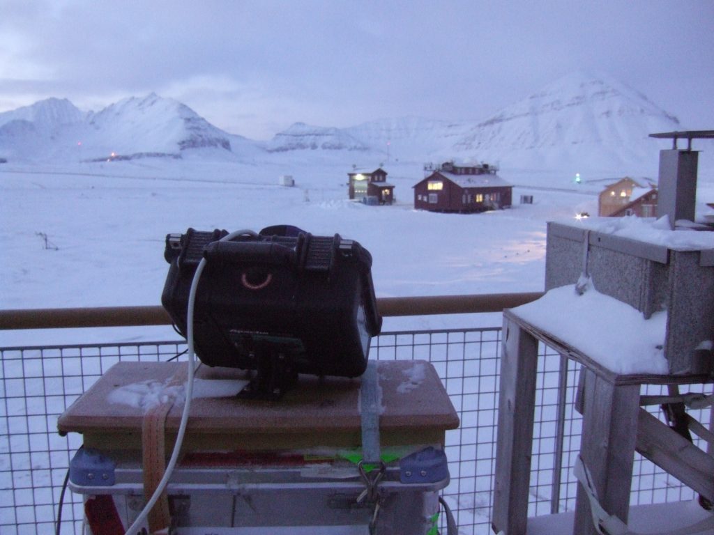
Camera box deployed at Ny Alesund, Norway in February, 2020.
Improving Access to Aerosol Measurements
Improving air quality worldwide means improving access to reliable aerosol measurement techniques. The CLidar and the IPN systems developed by Dr Barnes and his team are lower cost and may provide more accurate data than existing commercial lidar systems. The laser, camera and lens cost about $7000. To be used operationally, they also require weather-proof cases and a computer connection.
Camera lidar technology has previously only been operated by technicians and scientists. By building a more automated system, the team has opened up the possibility of commercial camera lidar. A commercially available instrument would be valuable for air quality, visibility, and cloud-base-height monitoring. For this reason, Dr Barnes has set up a small company to develop the CLidar and IPN commercially.
His team also developed streamlined software that quickly transfers data from the instrument to the user and analyses it. The same software can analyse data from both devices, and users can also operate the camera remotely via the internet.
In the future, Dr Barnes and his colleague, Dr Sharma, a physics professor at Central Connecticut State University, hope to extend the global reach of the instruments. ‘We have been working with a Physics teacher from the University of the Bahamas, Dr Amin Kabir. In 2012 I set up a group at Peking University working with the camera lidar,’ says Dr Barnes. By continuing this collaborative international effort, his team strives to make accurate aerosol measurements accessible to all.
Reference
https://doi.org/10.33548/SCIENTIA694
Meet the researcher
CREDIT: Kendal Lyon
Dr John Barnes
NOAA Global Monitoring Laboratory
325 Broadway R/GML
Boulder, CO
USA
Dr John Barnes earned his PhD in atmospheric physics in 1988 from the University of Minnesota. After a research position at the University of Michigan, Dr Barnes moved to the NOAA/GML Mauna Loa Observatory in Hawaii. He has worked at NOAA for over 23 years, including 17 years as the station chief. He is currently a visiting scientist at the NOAA Global Monitoring Laboratory in Boulder, Colorado. Dr Barnes has dedicated his career to measuring atmospheric particles that play a central role in human health, aircraft safety, and climate change. At NOAA, his research has focused on developing new and accessible tools to measure atmospheric particles and water vapour using laser techniques. Alongside his academic work, he has also started a small business to commercialise his inventions. He has published numerous articles published in peer-reviewed journals and has received multiple awards for his contributions to science.
CONTACT
E: John.E.Barnes@noaa.gov
W: https://gml.noaa.gov/staff/John.E.Barnes/
KEY COLLABORATORS
Dr Nimmi Sharma, Central Connecticut State University
Dr Amin Kabir, University of the Bahamas
FUNDING
NOAA, Small Business Innovative Research Program
FURTHER READING
JE Barnes, NCP Sharma, An inexpensive active optical remote sensing instrument for assessing aerosol distributions, Journal of the Air & Waste Management Association, 2012, 62, 198–203.
![]()
Want to republish our articles?
We encourage all formats of sharing and republishing of our articles. Whether you want to host on your website, publication or blog, we welcome this. Find out more
Creative Commons Licence
(CC BY 4.0)
This work is licensed under a Creative Commons Attribution 4.0 International License. 
What does this mean?
Share: You can copy and redistribute the material in any medium or format
Adapt: You can change, and build upon the material for any purpose, even commercially.
Credit: You must give appropriate credit, provide a link to the license, and indicate if changes were made.
More articles you may like

Dr Kati Rantala | Navigating Policy with the Logic of Regulatory Impact Assessment
Regulatory Impact Assessment (RIA) is a crucial process in policymaking, allowing decision-makers to assess the potential impacts of proposed regulations prior to implementation. Dr Kati Rantala of the University of Helsinki and her colleagues argue that by employing evidential reasoning and considering contextual factors, RIA helps policymakers make more informed decisions that better serve the needs of society. Understanding the logic behind RIA is essential for policymakers to design policies that have positive impacts on our communities and the world at large and for all affected by regulations to advocate for thorough and well-constructed impact assessment.

Do Gravitational Waves Exist? Critical Questions from Professor Jean-François Pommaret
Through a detailed analysis of mathematical frameworks, Professor Jean-François Pommaret challenges the established scientific consensus on gravitational waves, proposing that certain mathematical interpretations could question their existence. This article delves into the professor’s examination of the founding principles of general relativity, offering an insightful, alternative perspective on the ongoing dialogue between mathematics and physics.

Dr Kimberly Coy | Virtual Schooling: How Digital Education Can Increase Inclusivity
Virtual schooling – teaching conducted entirely online – has become increasingly important since the COVID-19 pandemic. Even prior to the pandemic, virtual schools were recognised for providing alternatives to students with needs beyond those catered for in traditional classroom settings. While research into the factors influencing the success of virtual schools is lacking, Dr Kimberly Coy of California State University, Fresno, is working to address this knowledge gap. She is particularly interested in the challenges facing the application of digital learning and strategies that may overcome these.

Dr Matthew Williams | Personality and Pain: The Role of Personality Traits in Musculoskeletal Rehabilitation
The interactions between body functions, mental processes, and the social environment are critical in healthcare but all too often not fully understood. For example, the field of musculoskeletal health involves treatment of the muscles, bones, joints, and connective tissues that support and move the body. Whilst clinicians are great at evaluating the physiological aspects of musculoskeletal problems, they often miss how an individual’s psychological factors can influence treatment outcomes. Dr Matthew Williams, at Baylor University in the USA, is pioneering the application of personality psychology to musculoskeletal intervention strategies.