
Professor Enzo Mantovani – Understanding Mediterranean Tectonics to Recognise Earthquake-prone Zones
Precisely predicting when earthquakes will happen is still a distant goal. However, local authorities could reduce the damage caused by such disasters if scientists could identify zones that are most likely to be affected by earthquakes. Gaining this information requires an in-depth knowledge of the ongoing tectonic situation in a given area. In the Mediterranean region, this knowledge is surrounded by considerable uncertainty, as different researchers have different hypotheses to explain tectonic processes in this area. Professor Enzo Mantovani and his team at the University of Siena, Italy, propose a new geodynamic interpretation that offers a plausible explanation for all major tectonic features observed in this area. Using their hypothesis, along with the seismic history of the region, the team has recognised a connection between the short-term development of tectonic processes and the distribution of major earthquakes.
Tectonic Evolution of the Mediterranean
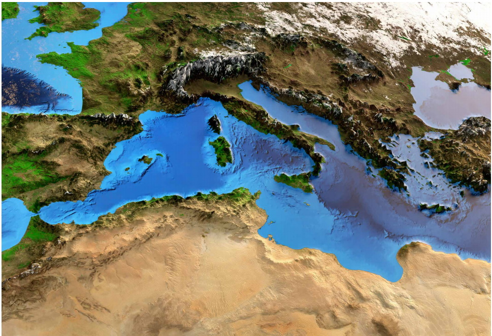
Over the last 30 million years, the tectonic and morphological situation in the Mediterranean region has undergone profound change. In this area, elongated regions of deformation where the African and Eurasian tectonic plates converge – called ‘orogenic belts’ – migrated by distances of several hundreds of kilometres and some also underwent strong distortions. In the wake of the migrating belts, crustal stretching occurred, forming thinned zones called ‘Back Arc’ basins, which are now part of the Mediterranean seafloor.
It is largely accepted that the driving force of tectonic processes in the Mediterranean region is the convergence between the African and Eurasian plates. However, since convergence mostly produces ‘compressional’ deformations, causing the Earth’s crust to become thicker and mountains to form, some researchers propose that other driving forces caused the formation of basins in the Mediterranean.
The most frequently cited hypothesis assumes that basin formation is driven by the gravitational sinking of subducted crust, called a ‘slab’. As the slab sinks, the so-called ‘subduction zone’ at the surface retreats, inducing crustal thinning in the overlying plate and forming a basin. This explanation is called the ‘slab-pull’ model. However, this hypothesis cannot account for some of the main tectonic features that are observed in the region, as extensively discussed by Professor Enzo Mantovani and his colleagues at the University of Siena.
In particular, it is very difficult to reconcile the complex evolution of the Tyrrhenian basin, developed in three distinct phases in both space and time, with the main implications of the slab pull model. For instance, numerical simulations of the tectonic mechanism predict the subsidence of the belt instead of the observed uplift in the Apennines and Calabria.
For over 40 years, Professor Mantovani and his colleagues have gathered vast amounts of data from multiple scientific disciplines, mainly geology, geophysics, tectonics, seismology and mathematical modelling, to reconstruct the past deformation pattern in the Mediterranean region. They accurately tested the compatibility of this reconstruction with geodynamic models. In doing so, they developed a hypothesis that can provide plausible and coherent explanations for a far greater number of the tectonic features observed in the Mediterranean, compared to previous hypotheses.
Explaining Crustal Thinning
Professor Mantovani and his team suggest that the occurrence of extensional deformation in a compressional context can be explained as an effect of ‘extrusion’. This process occurs when an orogenic belt becomes compressed between two converging plates, being flanked by a region of oceanic crust, called an ‘oceanic domain’. The shortening of the belt, which happens due to the compression, is accommodated by the lateral escape of buoyant orogenic material (called an extruding wedge), which overthrusts the adjacent denser oceanic domain. The load of this buoyant material perturbs the equilibrium in the collision zone, triggering the downward flexure of the denser oceanic domain. Once initiated, slab sinking continues, driven by plate convergence.
Experiments demonstrate that this extrusion process can generate extensional deformations in the wake of a migrating orogenic belt, which can move much faster than the converging plates. ‘The available evidence indicates that this process has generated the Balearic basin and the Central-Southern Tyrrhenian basin, involving the subduction of large old and cold Tethys domains,’ explains Professor Mantovani.
In the Balearic basin, a stretching of the crust began in the Oligocene epoch (34–23 million years ago), when the Alpine belt lay along the eastern side of the Iberian domain. Crustal thinning developed in the wake of this belt, which, being stressed by the convergence of the African and Eurasian plates, was forced to migrate eastwards and undergo considerable south-eastward bowing.
In another Mediterranean region, the southern Tyrrhenian basin, the crust began to stretch in the early Pleistocene, about 2.6 million years ago, in the wake of the migrating Calabrian wedge.
‘Explaining the generation of this system as an effect of a slab-pull driving force is particularly difficult, since the migrating Calabrian wedge underwent a fast uplift, south-eastward bowing and considerable fracturing,’ says Professor Mantovani. ‘In particular, it is hard to believe that an uplift of more than 2000 metres in one to two million years was caused by the pull of the sinking slab.’
The basic role of extrusion processes in the Mediterranean evolution is clearly suggested by an important piece of evidence: the fact that subduction of oceanic domains only occurred beneath extruding wedges. When this condition did not occur, for instance during the collisional phase of the Africa-Adriatic plate with Eurasia, the Ionian oceanic domain could very efficiently transmit compressional stresses without undergoing any subduction. This behaviour, also observed in other zones of the world, is explained by the fact that during long (geological) time intervals, the horizontal strength of the oceanic domain is not lower than that of a continental plate.
Finally, one can underline the fact that with the extrusion explanation, there is no need to assume the action of other driving forces in addition to the one provided by Plate Tectonic theory – that is, the convergence of the confining plates.
‘With the extrusion explanation, there is no need to assume the action of other driving forces in addition to the one provided by the Plate Tectonic theory, that is, the convergence of the confining plates.’
Tectonics and Earthquake Distribution
‘Any attempt at predicting the next development of a physical phenomenon requires the knowledge of its genetic mechanism,’ says Professor Mantovani. Thus, exploiting their knowledge of the real tectonic situation in the Mediterranean area, he and his research group have tried to obtain insights into the connection between the short-term development of tectonic processes and the distribution of major earthquakes in both space and time.
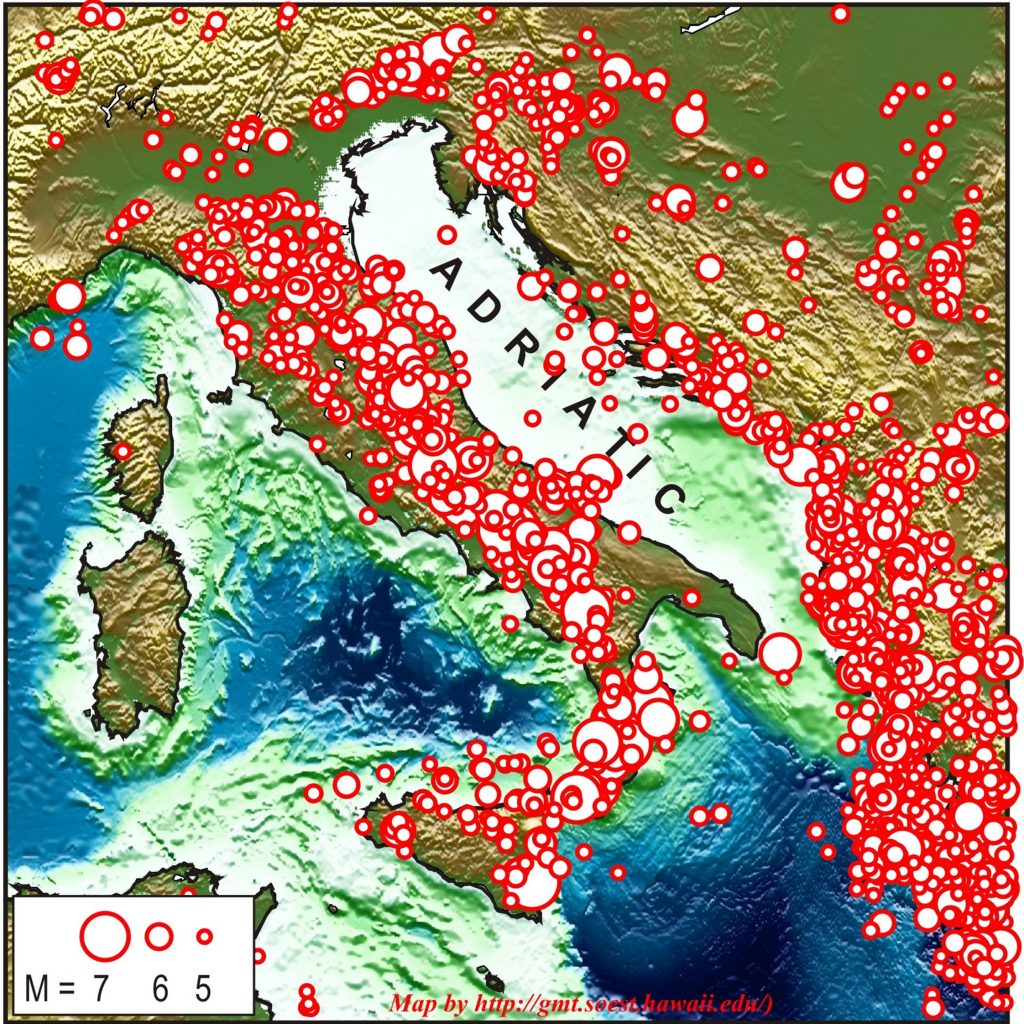
This attempt has the highest chance of success in the zones where the tectonic situation is relatively simple, such as the central Mediterranean region, where most seismic activity occurs in the orogenic belts that surround the Adriatic plate, which forms the seafloor of the Adriatic Sea between Italy and the Balkans (see the figure).
This activity is due to the fact that the Adriatic plate, stressed by the convergence of the confining plates, tries to move roughly northward. This motion is not continuous over time, being mainly allowed by the fault slidings that occur during major earthquakes along the boundaries of the Adriatic plate.
‘Each strong shock triggers the motion of the just decoupled Adriatic sector, which then propagates through the plate with rates controlled by the plate’s properties,’ says Professor Mantovani. ‘This process tends to involve more and more northern zones along the lateral borders of the Adriatic plate, up to reach the northern front of the plate in the Eastern Alps. This hypothesis is compatible with the distribution of major earthquakes that occurred along the Adriatic boundaries in the last four centuries.’
The above interpretation may provide a tool to locate zones where ongoing stresses, induced by the driving forces and past seismicity in tectonically connected zones, are closest to the strength of the crust. This approach has allowed the University of Siena team to recognise the Central-Northern Apennines as a priority zone, where some years later in 2016, strong earthquakes took place.
Informing Prevention Policies
‘The most important problem concerning earthquake mitigation in Italy is the fact that a large proportion of the buildings were built without any anti-seismic criteria,’ says Professor Mantovani. ‘Thus, the restoration of such a vast building heritage would require a very long prevention project. This problem could be addressed by the recognition of the zones most prone to next strong earthquakes, where prevention could be prioritised in the short-term.’
His team’s work aims to help local authorities to achieve this goal, by recognising patterns of seismic activity driven by ongoing tectonic processes. Such information could be essential in mitigating the effects of next major seismic disasters.
Reference
https://doi.org/10.33548/SCIENTIA695
Meet the researcher
Professor Enzo Mantovani
Department of Environment, Earth and Physical Sciences
University of Siena
Siena
Italy
Before his retirement in 2015, Professor Enzo Mantovani held the post of Professor in Solid Earth Geophysics at the University of Siena, Italy. His previous positions include research fellowships at the University of Siena and the UCLA University of Los Angeles, USA. He has devoted his decades-long career to understanding the geological evolution of the Mediterranean region, with over 100 articles published in peer-reviewed journals. Professor Mantovani’s research has included setting up seismic stations across Italy, reconstructing the tectonic history of the Mediterranean, and studying the link between tectonics and earthquakes. His work on seismic risk assessment has been used to manage resources for disaster prevention in Tuscany.
CONTACT
E: enzo.mantovani@unisi.it
KEY COLLABORATORS
Daniele Babbucci, University of Siena, Siena, Italy
Massimo Baglione, Regione Toscana (Prevention), Florence, Italy
Nicola Cenni, University of Bologna, Bologna, Italy
Vittorio D’Intinosante, Regione Toscana (Prevention), Florence, Italy
Caterina Tamburelli, University of Siena, Siena, Italy
Marcello Viti, University of Siena, Siena, Italy
FUNDING
Regione Toscana, Italy
Ministry of Public Education and Research, Italy
Dept. of Civil Protection, Italy
FURTHER READING
E Mantovani, C Tamburelli, D Babbucci, M Viti, N Cenni Tectonics and Seismicity in the periAdriatic Zones: Implications for Seismic Hazard in Italy, in Earthquakes – From Tectonics to Buildings, Walter Salazar, IntechOpen, 2020.
E Mantovani, M Viti, D Babbucci, C Tamburelli, N Cenni, Geodynamics of the central-western Mediterranean region: plausible and non-plausible driving forces, Marine and Petroleum Geology, 2020, 113, 104121.
E Mantovani, M Viti, D Babbucci, C Tamburelli, N Cenni, How and why the present tectonic setting in the Apennine belt has developed, Journal of the Geological Society, 2019, 176, 1291–1302.
![]()
Want to republish our articles?
We encourage all formats of sharing and republishing of our articles. Whether you want to host on your website, publication or blog, we welcome this. Find out more
Creative Commons Licence
(CC BY 4.0)
This work is licensed under a Creative Commons Attribution 4.0 International License. 
What does this mean?
Share: You can copy and redistribute the material in any medium or format
Adapt: You can change, and build upon the material for any purpose, even commercially.
Credit: You must give appropriate credit, provide a link to the license, and indicate if changes were made.
More articles you may like

Prof Candis M. Morello – Prof Jan D. Hirsch | Recent innovations in pharmacy education
A pioneering research team from the Skaggs School of Pharmacy and Pharmaceutical Sciences, University of California, San Diego, United States, has been instrumental in developing innovative techniques for teaching pharmacy students. The Next Generation of Pharmacist Educators (NextGen-RxEd) programme is a new method of training the next generation of pharmacist educators and academics. To help pharmacists and pharmacy students visualise the complex issues experienced by their patients, the team led by Professors Candis Morello and Jan Hirsch developed an innovative educational tool, called the Medication Therapy Management (MTM) Spider Web.

Professor Michael Yarus | How RNA Started the Conversation That Built Life
The genetic code stores the instructions for building proteins, yet how it first arose remains unclear. It likely did not appear fully formed, but instead emerged step by step from simple chemical interactions. In this study, a team led by Professor Michael Yarus at the University of Colorado Boulder shows how early ribonucleic acid (RNA) molecules could bind specific amino acids, creating the first coding relationships. These early interactions are then refined through evolutionary processes such as duplication and merging of partial codes. By combining the experimental data with computer simulations, the work provides a testable pathway from prebiotic chemistry to the modern genetic code.

Identifying Nutritional Risk in Early Childhood: Insights from NutriSTEP®
Early childhood is a critical period for growth and development, yet many young children face nutritionrelated risks that can go unnoticed. Professor Janis Randall Simpson and colleagues have developed NutriSTEP®, validated and reliable screening tools that help identify potential nutritional concerns in toddlers and preschoolers. Their large-scale analysis of Canadian data reveals patterns in diet, behaviour, and food access that could help guide early interventions and support healthy development.

Professor Tian Yu Cao | Twistor Theory: A New Framework for Quantum Gravity
At Boston University, Professor Tian Yu Cao is rethinking the foundations of modern physics. His work builds on twistor theory which demonstrates that spacetime is secondarily derived from twistor constructions, but goes further to highlight the most important implication of the Penrose transform in that the primary physical agents can only be mathematically described by elements of cohomology with the defining feature having roots in spin. This view of primary agents combines with Cao’s other major claim that quantum behaviour itself may arise from the physical property of spin leads to a new consistent framework of quantum gravity in which long-standing puzzles in black holes (evaporations) and cosmology (transitions between cycles of cosmos) can be adequately addressed, with the crucial help from the on-going development of operator product expansion formular defined on twistor space.