
Professor Jim Nelson – Predicting Disasters Using Global Water Intelligence
Accurate knowledge of the water cycle is essential for predicting disasters such as floods and droughts. However, it’s not easy to obtain good information from traditional weather and water forecasts. The Group on Earth Observations Global Water Sustainability initiative (GEOGloWS) provides hydrologic forecasts through an accessible web service to assist local water users. Partnering with water scientists worldwide, Professor Jim Nelson of Brigham Young University worked with the European Centre for Medium-Range Weather Forecasts to develop a global streamflow service. This service provides local communities with actionable water intelligence, enabling them to focus on solutions to water-related problems.
A Global Water Forecasting Project
Water is the world’s most precious natural resource. A limited supply of freshwater supports the global food chain, sustains human life and powers industry. At a time of worldwide population growth and increasing water stress due to climate change, effective management of this critical resource is key to ensuring food security, avoiding conflict and promoting sustainable development.
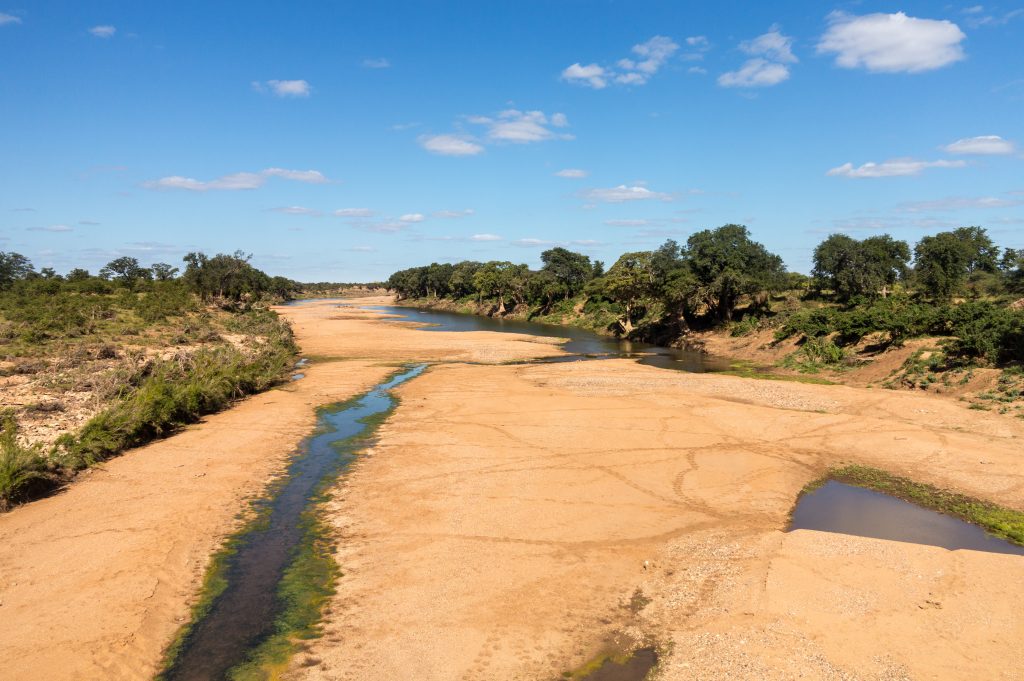
Managing the world’s water supply requires accurate forecasts that warn of devastating events such as droughts and floods. Predicting these disasters with sufficient lead time requires accurate river flows and depth measurements. However, many people who are vulnerable to water insecurity, or hazards such as flooding, live in countries with limited water monitoring infrastructure or the modelling capability necessary to produce good data. In many developing countries, this lack of data means that floods and droughts are difficult to predict, making their impacts far more devastating.
In these areas, water modelling can be an essential tool for forecasting water-related disasters. When local river gauge data is unavailable, models can use global datasets, such as observations made by satellites, to forecast water flows worldwide.
However, while developed countries have access to sophisticated river flow models, developing countries can be at a disadvantage. Models are expensive to create, can require specialised equipment or skills, and are difficult to program. In addition, models that predict river flow for the entire globe often lack enough detail to produce usable information on a local scale.
Previous solutions to these problems have involved donor countries funding hardware, software and specific technical training to develop and run local forecasting systems with the power to provide information that is useful in decision-making. However, as maintenance costs continue after the project funding ends, projects like these are not always sustainable in the long term.
The Group on Earth Observations GEOGloWS initiative is dedicated to tackling these challenges. Along with GEOGloWS’s international team of water experts, Professor Jim Nelson at Brigham Young University has led the creation and testing of a transformative global system for delivering actionable streamflow information. Water management agencies in developing countries can access the global forecasts for free. The information is useful as is, but can also be used to implement national systems or strengthen locally generated modelling data.
Because the system is maintained and operated as a cloud service, vulnerability to computer and software updates, or limited local capacity, can be mitigated. This also overcomes the high cost of maintenance or improvement, because each local user immediately benefits from upgrades and improvements made to the global data service.
The GEOGloWS ECMWF Streamflow Service aims to provide the necessary information to decision-makers who respond to droughts and floods. This has the potential to save lives and infrastructure and increase food security. It provides forecasts in areas that lack water observation data, providing local organisations with crucial information to help reduce water-related vulnerabilities.

Developing a Global Prediction System
Numerical models of the global land surface can be used to predict important water processes such as evaporation, soil moisture levels, the amount of snow on the ground – and crucially, water flow in rivers. However, developing a global modelling system with enough detail to produce sound local forecasts is no easy task.
Professor Nelson and his colleagues addressed this problem by partnering with the European Centre for Medium-Range Weather Forecasts (ECMWF), one of the world’s leaders in meteorological forecasting, to map the water flow predicted by their global model to watershed catchments, and then routing these flows through a fine-scaled stream network. In this way, the GEOGloWS streamflow services use trusted available global data to produce detailed local forecasts.
The new model is beneficial in areas where observations are scarce, such as transboundary waters – aquifers, rivers, and lake basins shared by two or more countries. It can be challenging to produce forecasts locally in these regions due to the need for data sharing and coordination between countries.
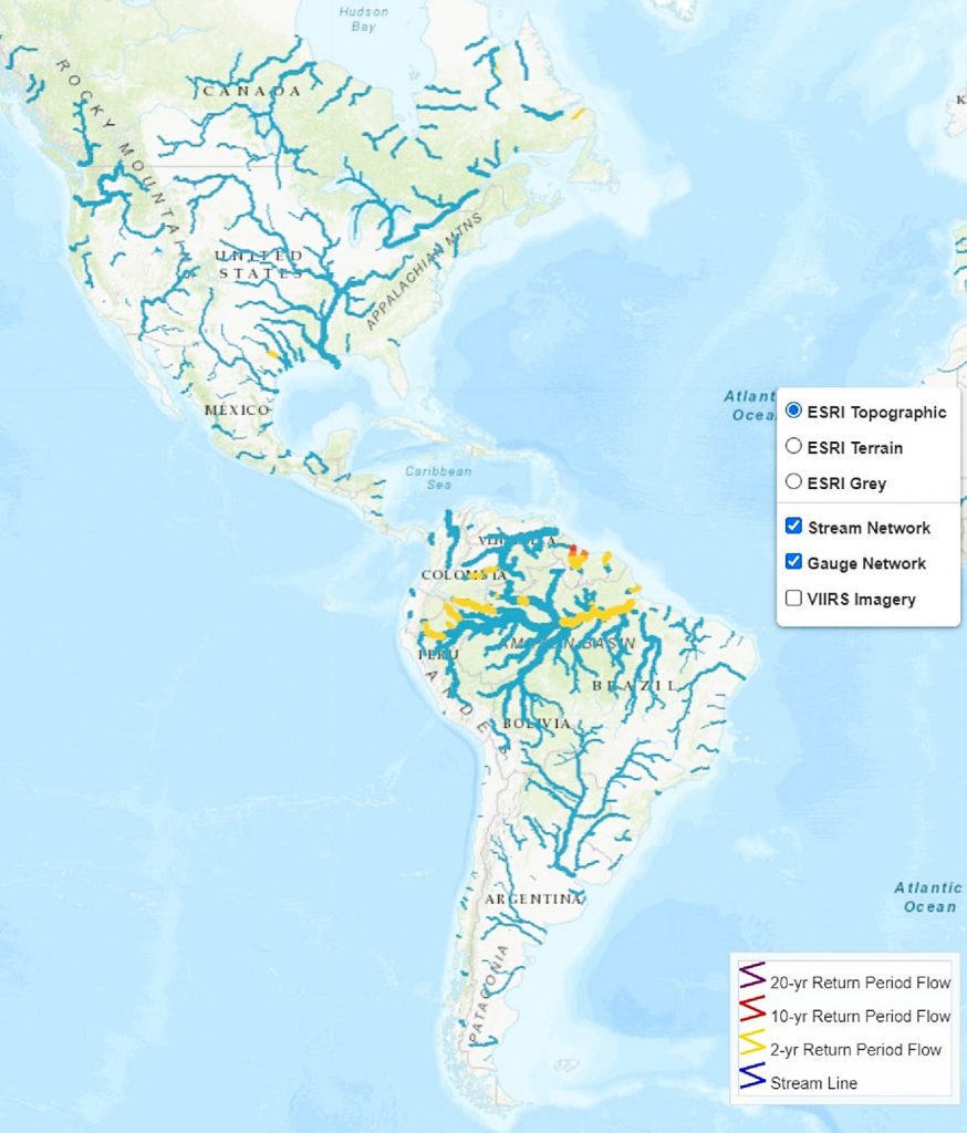
For this reason, the researchers tested their new forecasting system on two huge transboundary river basins: the Ganges, Brahmaputra, and Meghna rivers in South Asia and the Mekong River in Southeast Asia. Both river basins are densely populated and suffer heavy rainfall from yearly monsoons, making them prone to flooding.
The team produced river flows for the two basins using the new system. They compared the simulations to local measurements of river flow to test the accuracy of their predictions. The GEOGloWS global model downscaled to local streams could predict water flows with enough detail to produce actionable hydrologic information.
To ensure the new system continues to improve, the researchers also developed an application called the Historical Validation Tool. The tool is used to monitor the performance of GEOGloWS by comparing the river flow predictions to observations. If it detects a bias in the model at that location – meaning the model always overestimates or underestimates flow in predictable amounts – the model can predict the errors in future forecasts and correct them.
A Truly Accessible Service
The GEOGloWS ECMWF Streamflow Service produces useable river flow predictions on a local scale, using freely accessible global datasets. However, accurate forecasts can’t be helpful unless the results are readily available and clearly presented.
Large-scale models produce a vast amount of data, so sharing and presenting the forecasts is a challenge in itself. In addition, the groups interested in water data – including scientists, emergency responders, decision-makers, and the general public – have a diverse set of needs, making the communication of results a significant challenge.
The GEOGloWS ECMWF Streamflow Service uses cloud computing to run the forecasts, meaning that local forecasting agencies don’t need expensive computing hardware. ‘GEOGloWS centralises the cyberinfrastructure, human capacity, and other components of hydrologic modelling using the best forecasts and expertise available,’ explains Professor Nelson.
Previously, every local agency wishing to produce water forecasts would have had to download huge volumes of input data, such as terrain information, land-use data, and weather data. They would also have to provide computers, software, and experts to produce the forecasts. ‘Having to replicate this resource everywhere is expensive in terms of the cyberinfrastructure and human capacity required,’ says Professor Nelson.
In contrast, users of GEOGloWS can retrieve the forecasts through web services, meaning they are available to anyone with a computer and an internet connection. Data on a river-by-river basis can be accessed and used in simple web applications. Users can see maps and graphs showing predicted river flow volumes or use them to create derivative information as needed. They can also obtain historical simulation data on each river, which acts as a surrogate to observed data that provides information about what are low, normal, and high flows. ‘Our approach represents a paradigm shift from the provision of complex weather forecasts to be transformed into local hydrological information, towards the provision of hydrological forecasts,’ says Professor Nelson.
The Historical Validation Tool, facilitates adding local river flow measurements to the forecast system to produce greater confidence and potential improvements to the forecasts. Forecasting organisations can also create customised tools that use the forecasted data to help solve specific problems. One such customisation made by the International Centre for Integrated Mountain Development (ICIMOD) is the Bangladesh Transboundary Streamflow Prediction Tool. This tool provides crucial forecasts for Bangladesh’s Flood Forecasting and Warning Centre, because approximately 92% of the watershed lies outside of its boundaries. This information is critical in places where little if any information is shared across boundaries.
Even when forecasts are provided, expert knowledge will still be necessary to interpret model results. Local organisations need to understand the model assumptions, limitations, and uncertainty, and decisions surrounding forecasted events remain the responsibility of local communities. But with water forecasts readily available, disaster agencies can focus more of their time and resources on some of the most pressing water-related issues society faces. ‘Local organisations can focus on the decisions made from hydrologic information rather on the development of the actionable hydrologic information,’ adds Professor Nelson.
A Global Effort
River flooding is one of the most common and most expensive natural disasters around the globe. Early warning systems are a crucial strategy in reducing environmental hazards such as floods and droughts, but accurate forecasts aren’t always available locally. The GEOGloWS project provides water forecasts to regions where measurements are scarce, bringing global water management capabilities to local decision-makers. Distribution of water information, such as flow forecasts, through easy-to-use web services, removes the burden and expense of carrying out modelling locally, improving the transfer of technology to the places that need it most.
The forecasts will also benefit the global economy by informing the insurance industry about water-related risks. ‘GEOGloWS benefits the global economy by also providing water intelligence to sectors such as the insurance and reinsurance industry, and many others that need to make high-risk investment decisions,’ explains Professor Nelson.
GEOGloWS is the work of a truly international team of experts and demonstrates the power of collective action to solve global challenges. The success of the GEOGloWS project hinges on fruitful collaborations between water scientists and local stakeholders. ‘One of the most important achievements of the project is the mobilisation of a wide international group of experts to assemble this service,’ says Professor Nelson. Collaborations with forecasting agencies have been crucial in ensuring the service can be implemented locally. ‘We have definitely been encouraged lately by powerful stories of the possibilities GEOGloWS is achieving to try and do more to extend its reach,’ he continues.
Fuelled by the expertise and reputation of the ECMWF forecasts, the GEOGloWS partnership is continually developing the streamflow services. In the future, the team will continue to extend the global reach, as well as monitoring and improving its performance. Professor Nelson concludes: ‘We hope to be able to continue the effort to improve the model accuracy as well as the tools to access the streamflow services while growing the community that supports this important effort.’
Reference
https://doi.org/10.33548/SCIENTIA682
Meet the researcher
Professor E. James Nelson
Department of Civil and Environmental Engineering
Brigham Young University
Provo, UT
USA
Professor Jim Nelson earned his PhD in water resources engineering at Brigham Young University in Utah, where he progressed from Research Assistant, to Research Associate, to Assistant Professor. In 2008, he became a full Professor in the Department of Civil and Environmental Engineering. Over his decades-long career, Professor Nelson has been a pioneer in developing digital modelling and informatics tools to help engineers and forecasters better simulate hydrological processes. His research has resulted in the development of water modelling software used by hundreds of organisations globally. At Brigham Young University, he supervises and teaches numerous undergraduate and graduate students alongside his research activities. Professor Nelson has held editorial positions for scientific journals, as well as prestigious committee positions. He has also been awarded multiple fellowships and awards for his contributions to both teaching, scholarship and technology transfer.
CONTACT
E: jimn@byu.edu
W: https://hydroinformatics.byu.edu/
KEY COLLABORATORS
Florian Pappenberger, Christel Prudhomme – ECMWF
Peter Salamon – JRC
Angelica Gutierrez – NOAA and GEOGloWS chair
Dan Irwin, Nancy Searby, Ashutosh Limaye NASA – SERVIR
Brad Doorn – NASA Water Resources Applied Sciences
Norm Jones, Dan Ames, Gus Williams – Brigham Young University Hydroinformatics
Riley Hales, Jorge Luis Sanchez, Chris Edwards, Alan Snow and many other BYU Students
Cédric David – JPL
David Maidment – University of Texas
Michael Souffront, Nathan Swain – Aquaveo LLC
Steve Kopp – esri
Nagaraja Harshadeep – World Bank
IMPLEMENTING PARTNERS
Israel Acosta, Fidel Perez, Instituto Nacional de Recursos Hidráulicos (INDRHI), Dominican Republic
Berta Olmedo, Deisy Lopez, Comité Regional de Recursos Hidráulicos (CRRH), Central America
Harold Lluaca, Servicio Nacional de Meteorología e Hidrología (Senamhi), Peru
Fabio Bernal, Instituto de Hidrología, Meteorología y Estudios Ambientales (IDEAM), Colombia
Amir Givati, Israeli Fire and Rescue – Authority (IFRA), Israel and West Bank
Manuel Conde, Empresa Nacional de Energía Eléctrica (ENEE), Honduras
Calvince Wara, Regional Centre for Mapping of Resources for Development (RCMRD), Kenya
Mir Matin, Birendra Bajracharya, Kiran Shakya, The International Centre for Integrated Mountain Development (ICIMOD), Nepal
FUNDING
NASA-GEO
NASA-SERVIR
FURTHER READING
M Souffront Alcantara, EJ Nelson, K Shakya, C Edwards, W Roberts, C Krewson, DP Ames, NL Jones, A Gutierrez, Hydrologic modeling as a service (HMaaS): a new approach to address hydroinformatic challenges in developing countries, Frontiers in Environmental Science, 2019, 7, 158.
JS Lozano, GR Bustamante, R Hales, EJ Nelson, GP Williams, DP Ames, N Jones, A streamflow bias correction and performance evaluation web application for GEOGloWS ECMWF streamflow services, Hydrology, 2021, 8, 71.
X Qiao, EJ Nelson, DP Ames, Z Li, CH David, GP Williams, W Roberts, JL Sánchez Lozano, C Edwards, M Souffront, MA Matin, A systems approach to routing global gridded runoff through local high- T resolution stream networks for flood early warning systems, Environmental Modelling and Software, 2019, 120, 104501.
MS Sikder, CH David, GH Allen, X Qiao, EJ Nelson, MA Matin, Evaluation of available global runoff datasets through a river model in support of transboundary water management in south and southeast Asia, Frontiers in Environmental Science, 2019, 7, 171.
GEOGloWS APP
https://geoglows.apps.aquaveo.com/apps/geoglows-hydroviewer/
https://tethys.byu.edu/apps/geoglows-hydroviewer/
![]()
Want to republish our articles?
We encourage all formats of sharing and republishing of our articles. Whether you want to host on your website, publication or blog, we welcome this. Find out more
Creative Commons Licence
(CC BY 4.0)
This work is licensed under a Creative Commons Attribution 4.0 International License. 
What does this mean?
Share: You can copy and redistribute the material in any medium or format
Adapt: You can change, and build upon the material for any purpose, even commercially.
Credit: You must give appropriate credit, provide a link to the license, and indicate if changes were made.
More articles you may like

Professor Tian Yu Cao | Twistor Theory: A New Framework for Quantum Gravity
At Boston University, Professor Tian Yu Cao is rethinking the foundations of modern physics. His work builds on twistor theory which demonstrates that spacetime is secondarily derived from twistor constructions, but goes further to highlight the most important implication of the Penrose transform in that the primary physical agents can only be mathematically described by elements of cohomology with the defining feature having roots in spin. This view of primary agents combines with Cao’s other major claim that quantum behaviour itself may arise from the physical property of spin leads to a new consistent framework of quantum gravity in which long-standing puzzles in black holes (evaporations) and cosmology (transitions between cycles of cosmos) can be adequately addressed, with the crucial help from the on-going development of operator product expansion formular defined on twistor space.

Professor Mikhail V. Medvedev | Plasma Waves in Extreme Magnetic Fields: Exploring the Quantum Regime
In environments where magnetic fields exceed even the limits of classical physics, such as magnetars and next-generation laser experiments, plasma behaviour is fundamentally altered by quantum effects. Professor Mikhail V. Medvedev and colleagues have developed a framework to understand how these extreme conditions reshape plasma waves, revealing that while familiar wave structures persist, their properties are significantly modified. These insights provide a foundation for interpreting astrophysical observations and advancing high-energy plasma experiments.

Alex Spezowka | Responsible Research Writing in the Age of AI: From Detection to Transparency
Artificial intelligence is often discussed as a future challenge for research, yet it is already shaping how many papers are written. Drawing on emerging evidence and recent analysis, work led by Alex Spezowka highlights a key shift in thinking: rather than trying to detect AI use, the focus is moving towards how it can be used responsibly. This has important implications for how research is produced, evaluated, and trusted.
Laura Daniela Muñoz Duarte – Jo Philips | Rethinking Hydrogen Use in Acetogenic Bacteria: Kinetics, Thresholds, and Biotechnological Potential
Acetogenic bacteria can convert carbon dioxide and hydrogen into useful products, making them promising tools for sustainable biotechnology. Research led by Laura Muñoz and Jo Philips reveals that hydrogen consumption follows a simpler kinetic pattern than previously assumed, while also uncovering major differences between species in how efficiently they operate at low hydrogen levels. Together, these findings provide a clearer framework for selecting and optimising acetogens for industrial applications.