
Dr Micah Russell | Underneath the Eaves: Estimating Canopy Snow Interception
In many cold regions of the world, snowfall is the primary form of water input to the environment. To a greater degree than rain, snowfall can be prevented from reaching the ground through interception by the canopies of trees, meaning that in heavily forested areas, very little snow reaches the ground immediately. Dr Micah Russell from Western Colorado University and his colleagues have developed a new method using lasers to determine the volume of snow intercepted by forest canopies to help better understand the hydrology of these regions.
Precipitation and Interception
In the water cycle, precipitation is the process by which atmospheric water returns to the surface. Depending on atmospheric conditions, this precipitation can take several forms, ranging from small barely-there droplets to pellets of ice. For cold regions of the world, the primary form of precipitation is snowfall. As the snow melts, it runs off into streams or is absorbed into the ground, where it can be used by plants living in the region.
In thickly forested areas where snow is the primary precipitation, a significant amount of snowfall never reaches the ground, instead being caught in the canopies of the trees. While some fraction of the intercepted snow may reach the ground through wind-driven unloading or through melting, a good deal of it is lost to other processes. The top layers of snow in the canopy are exposed to energy in the forms of sunlight and wind. This energy can excite the surface molecules of water enough to turn them straight from water ice to water vapour: a process called sublimation. This process can return water that falls as snow straight to the atmosphere without it ever reaching the ground.
According to Dr Micah Russell from Western Colorado University, under certain circumstances, this process of interception and sublimation has been shown to account for around 60% of all the precipitation that falls as snow over a forested region. Having accurate measurements of the amount of snow intercepted by a forest canopy is, therefore, incredibly important for properly understanding the hydrology of these regions. To help measure this caught snow, Dr Russell and his colleagues developed a new laser-based method for measuring and mapping snow interception in forested regions.
Snow Interception Measurements
Despite the importance it plays in the hydrology of a region, the amount of snow captured by the forest canopy remains difficult to measure and model. There are many factors that contribute to the amount of snow that can be captured, which can be grouped into intrinsic and extrinsic variables.
Intrinsic factors have to do with the forest itself and include the type of vegetation and its stiffness, the three-dimensional canopy structure, and the spacing of trees within the forest. A dense canopy that includes wide and stiff branches with irregular shapes will intercept a lot more snow than a canopy formed of thinner, bendier, regularly spaced branches.
Extrinsic factors are those that have to do with the types of snow and include the structure of the crystals, the water content of the snow, humidity, and wind speed. These factors combine to determine how well snow sticks to both itself and to vegetation.
The first challenge for researchers working in this field is how best to measure the snow captured by an individual tree, which can then be used to estimate snow intercepted by a forest canopy. To measure the amount of snow directly captured by a tree, researchers have been limited to experimentally weighing trees or branches laden with snow. This process is both time-consuming and resource-intensive.
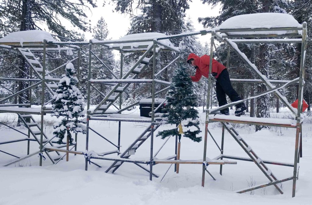
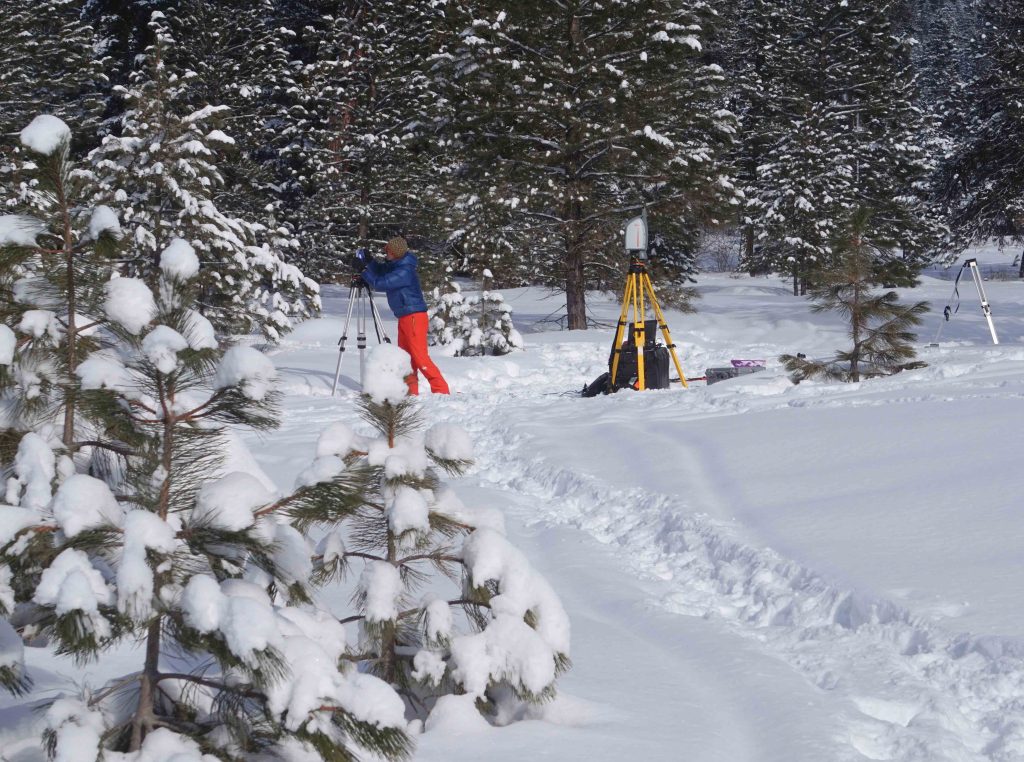
To make this process easier, Dr Russell has developed a method using a Terrestrial Lidar System (TLS). Lidar (light detection and ranging) works by measuring the time taken for laser light to be reflected from an object and returned to the emitter. This process records the angle and distance of the reflection point from the emitter, and how strong the reflection was. The data from TLS can be used to create a hugely detailed three-dimensional model of objects, including trees.
To work out the amount of snow that has been intercepted by a tree, Dr Russell takes two sets of measurements. The first measures the tree with no snowfall on it; these data are used to determine the initial volume of the tree, which is then compared to the volume of the tree with snow in its canopy. Dr Russell’s team performed 24-hour, automated TLS scans on two continuously weighed trees. They found that the snow mass estimates using TLS data compared favourably with traditional tree weighing.
Dr Russell explains that there are several key advantages to using this method, such as the ability to determine the amount of snow captured in each layer of the tree’s canopy and speedy data collection that can be easily integrated into snow interception models. To improve the estimation of snow interception using this method, Dr Russell suggests integrating data on snow density to transform snow volume to mass, and performing more experiments on forests with different compositions and under different temperature conditions.
Canopy Capture Models
Current hydrological and streamflow prediction models rely on snow interception estimates that are difficult to produce and are prone to errors. Calculating the snow intercepted by a single tree and scaling this across a wide area runs into problems with changing terrain and vegetation types, and comparing a forested area with a cleared area to produce estimates doesn’t account for wind re-depositing snow or the effects of snow slipping off branches. Very often, hydrological models rely on simple proxies for snow interception, including leaf area index (LAI) or canopy closure (CC). However, this only gives a two-dimensional view of the forest, and doesn’t account for the three-dimensional structure of the canopy that increases the interception rate of snow.
To try and resolve these issues, Dr Russell has developed a method using data gathered via Airborne Laser Scanning (ALS) systems to determine the canopy structures that make the most impact on snow interception. ALS works in the same way as TLS but is mounted on an aircraft or drone in order to scan large areas quickly. ALS systems have previously been used to great effect to create high-resolution three-dimensional maps of archaeological finds or places experiencing rapid landscape change, and are particularly useful in gathering data about regions that are physically difficult to reach or obscured by vegetation. Using data gathered from ALS can also help researchers detect detailed information about the structure of a forest, providing information about tree height, volume, and canopy structure.
Dr Russell explains that previous studies have demonstrated that ALS data can provide enough intrinsic information about the canopy that, combined with meteorological information, researchers can make estimates about snow interception that outperform existing methods and models. But, whilst these studies show the potential of ALS for improving models of snow interception, there are still questions about which of the canopy metrics derived from ALS have the most impact on snow interception. These questions remain difficult to answer, not least because it is difficult to gather data on snow interception directly across a range of different trees.
Nonetheless, in an effort to address this, Dr Russell and the team gathered data from the Bear Basin meadows in central Idaho. Using TLS, Dr Russell scanned 14 different snow-free trees and clumps of trees, chosen for their varying sizes and structures. Later, once snow had fallen, they rescanned the trees to estimate how much snow they had captured. The snow-on measurements were repeated a month later, to try and help answer how much the air temperature affected the interception rate. Once the data had been gathered from the ground, it was compared to historical ALS data taken in the same area. The team used a suite of ALS-derived aerial canopy metrics to predict the on-the-ground TLS-derived snow volumes.
A range of canopy structures identifiable via ALS had an impact on snow interception. These included the length of the crown of the tree and its distribution from the stem, the volume of the tree and its crown, the crown surface area, the tree height, and the number of unobstructed laser returns (i.e., the first returns only, not instances where the laser bounces off multiple layers of the canopy). Dr Russell found that the length of the crown was the most impactful canopy variable in estimating snow interception, followed by the whole tree volume, and then the amount of unobstructed laser returns. The model results suggested that whilst extrinsic factors do play a part in the amount of snow captured, a modest number of intrinsic forest factors alone can be used to estimate the interception likelihood over large areas.
Importantly, Dr Russell’s model demonstrated a marked improvement over models that relied only on LAI and CC in their calculations. He now suggests that future research could use their work on ALS-derived canopy structures to expand our understanding of how extrinsic forest structure, combined with local climatic variables, influences snow interception and persistence in the canopy across forest stands of different types. Dr Russell is indeed currently advising a graduate student on a related study near Crested Butte, Colorado.
Dr Russell’s work has shown that by using laser systems, we can make much more accurate estimates of the snow intercepted by the canopies of trees. Integrating this data with aerial scans of forests may allow for improved streamflow models as well, giving us unique insight into the hydrology of these snow-covered forests and their importance to downstream habitats and communities.
SHARE
DOWNLOAD E-BOOK

REFERENCE
https://doi.org/10.33548/SCIENTIA979
MEET THE RESEARCHER
Dr Micah Russell
Western Colorado University
Colorado
USA
Dr Micah Russell is an environmental scientist with a diverse research portfolio that spans wetland and river restoration, water supply planning, and remote sensing. In 2020, Dr Russell achieved his PhD in Water Resources from the University of Idaho, where he specialised in studying snow hydrology and the effects of intensifying droughts on seasonal wetlands. With extensive experience in industry and academia, Dr Russell now teaches and mentors students in environmental project management as an Assistant Professor of Environment and Sustainability at Western Colorado University. He is keen that his students obtain as much practical experience as possible and work on projects directly involving the local community.
CONTACT
E: mrussell@western.edu
W: https://western.edu/people/micah-russell/
KEY COLLABORATORS
Jan U. H. Eitel, Tim El, Link, and Ian Hellman (University of Idaho)
Carlos A. Silva (University of Florida)
Andrew J. Maguire (Conservation Science Partners)
FUNDING
National Aeronautics and Space Administration
National Science Foundation
US Department of Energy
Curt Berklund Fund
FURTHER READING
M Russell, JUH Eitel, TE Link, CA Silva, Important Airborne Lidar Metrics of Canopy Structure for Estimating Snow Interception, Remote Sensing, 2021, 13, 4188. DOI: https://doi.org/10.3390/rs13204188
M Russell, JUH Eitel, AJ Maguire, TE Link, Toward a Novel Laser-Based Approach for Estimating Snow Interception, Remote Sensing, 2020, 12(7), 1146. DOI: https://doi.org/10.3390/rs12071146
![]()
REPUBLISH OUR ARTICLES
We encourage all formats of sharing and republishing of our articles. Whether you want to host on your website, publication or blog, we welcome this. Find out more
Creative Commons Licence (CC BY 4.0)
This work is licensed under a Creative Commons Attribution 4.0 International License. 
What does this mean?
Share: You can copy and redistribute the material in any medium or format
Adapt: You can change, and build upon the material for any purpose, even commercially.
Credit: You must give appropriate credit, provide a link to the license, and indicate if changes were made.
SUBSCRIBE NOW
Follow Us
MORE ARTICLES YOU MAY LIKE

Dr Rhett Martin | Governing Nature at the Edge of Collapse
For millions of men, ageing brings with it a set of frustrating and often disruptive urinary symptoms. These symptoms, caused by benign prostatic hyperplasia, or BPH, can affect sleep, confidence, and overall quality of life. Traditionally, treatment follows a familiar path. Patients begin with medications, often for years, and may eventually progress to surgery if symptoms worsen. Yet this pathway is not without its drawbacks. Medications can cause side effects, while surgery carries risks and recovery time. In recent years, a minimally invasive interventional radiology procedure called prostate artery embolisation, or PAE, has begun to challenge this traditional model. At the forefront of this shift is a collaborative research group, led by Dr. Nicholas Brown of the University of Queensland, whose series of P-EASY studies has explored whether PAE could transform how BPH is treated, particularly at earlier stages.

Nick Martin | Data Assimilation: Overcoming AI’s Data Uncertainty Limitations for Water Resources
Water resources are essential for human life. Knowing how to manage water, both now and in the future, is necessary to continue using it as well as possible. Nick Martin and Jeremy White are examining limitations to artificial intelligence applications in water resources generated from noisy and estimated data sets. For poor quality data sets, they found that machine learning models will perform poorly relative to tools that explicitly include physics-based descriptions of physical processes; this is because physics-based calculations can use both data and physics knowledge through data assimilation techniques.

Nick Martin | The Future of Floods: Smarter Risk Tools for Sustainable Water Management in a Changing Climate
Sustainable decision-making requires balancing the costs borne by today’s society with those that will fall on future generations. Climate change is intensifying extreme weather, making floods more severe because a warmer atmosphere can hold and deliver a larger volume of water as precipitation. It may also be the case that severe floods are becoming more frequent as drought becomes more frequent, average conditions rarely occur, and weather oscillates between short duration wet and long duration dry extremes. Worryingly, traditional infrastructure (often designed using outdated, backward-looking models) risks failing under these evolving conditions.
Nick Martin from Vodanube LLC, and his colleagues have applied Probabilistic Risk Assessment (PRA) to flood inundation. Their research optimises current adaptation and future mitigation strategies, even while acknowledging PRA’s limitations. The team demonstrates how this approach can guide more resilient water resource management, and highlights opportunities for further study.

Dr James D. Burrington | Fuelling Hydrogen’s Role in a Net Zero Future
Hydrogen is often touted as the fuel of the future, but how much can it really contribute to global decarbonisation? Dr James D. Burrington, founder of NiceChemistry.com, has modelled how hydrogen technologies, particularly green hydrogen, might support worldwide net zero goals. His research applies rigorous metrics to assess energy efficiency, cost, emissions, and land use. This revealed that, while hydrogen may not directly replace electricity, it could be critical in decarbonising sectors where electrification falls short.