
Mr Daniel Schroeder | Key Advances in Modelling Flood Water Management
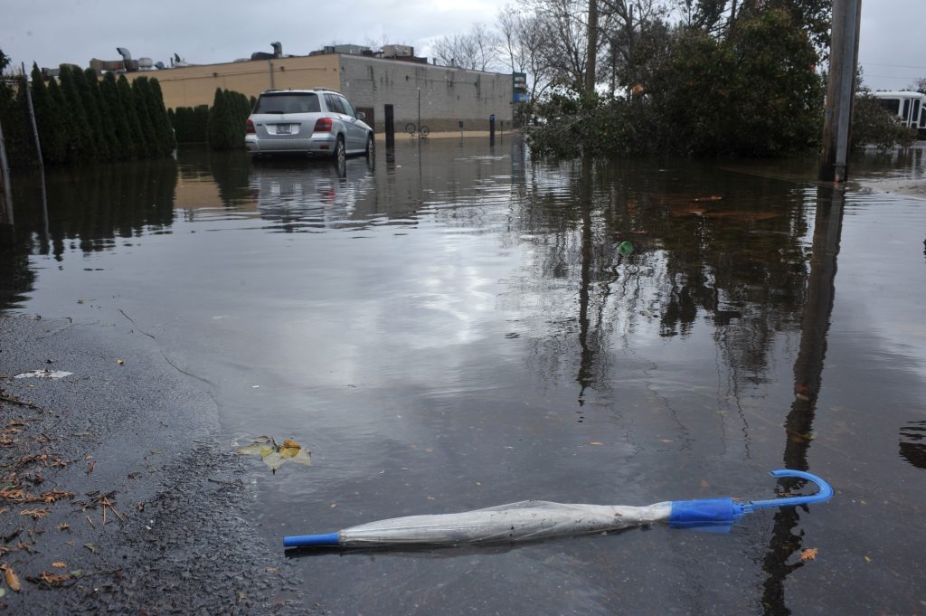
Urbanisation and a reduction in natural environments, together with inadequate infrastructure and increased storm events mean that we are vulnerable to the effects of flooding. Mr Daniel Schroeder at the Emergent Technologies Institute in the USA is working with his team to model the effects of storm events and evaluate the effectiveness of stormwater management options in urban areas.
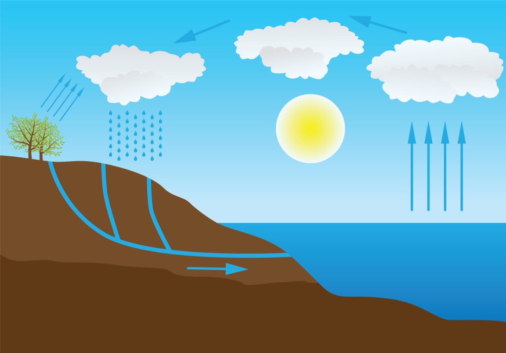
The Hydrological Cycle
Hydrology is the branch of science concerned with the properties of the Earth’s water, especially its movement in relation to land. The hydrological cycle is commonly illustrated as the movement of water – from the precipitation from clouds falling to Earth, water run-off down a mountain to a water body such as a river or lake, and finally, evaporation and trans-evaporation from said water body and trees. More detailed illustrations show the infiltration of rainwater into the ground, with further arrows into the groundwater aquifer and then on into the lake, completing the cycle.
Urbanisation and a reduction in natural environments, such as grassland and tree cover, have impacted the natural flow of the hydrological cycle, and insufficient stormwater management systems, coupled with increased storm events caused by climate change, have led to an increase in flooding of urban areas.
Importance of Natural Environments on The Hydrological Cycle
Natural environments such as grassland and tree cover play an important role in the hydrological cycle and in reducing the negative impact of increased stormwater. Firstly, by providing a physical buffer, rainwater is slowed down as it makes its way to Earth, and therefore, the impact of rainfall on an area is lessened. Secondly, plant roots spread down through the soil to absorb water, keeping the soil structure permeable, with little air pockets acting as a sponge and allowing the infiltration of water down from the surface and through the ground. Roots also hold the soil together, helping to prevent erosion in times of high rainfall and a subsequent increase in run-off.
When replaced with hard, impermeable structures such as concrete or buildings, the natural hydrology is disrupted, and so water can no longer soak into the ground to replenish important underground water reservoirs, a process known as groundwater recharge. Instead, water will accumulate on the surface and travel the shortest route to a water body – overland. With no mediation to the speed or amount of water travelling across the ground aside from insufficient urban drainage systems, the accumulation of stormwater, with nowhere else to go, will inevitably lead to areas of flooding.
Groundwater Recharge
Groundwater recharge is the process of water passing from the surface down through the soil to underground reservoirs. These reservoirs are incredibly important as they provide a major source of potable (drinking) water for the human populace in the area, and a decrease in water levels below ground can lead to an increase in the occurrence of subsidence or sinkholes.
Several factors can affect the efficiency of groundwater recharge on top of urbanisation and removal of vegetation. These include the topography of the land, the type of soil type present, including the type of arenosol (soil made up mostly of sand), how deep the groundwater lies, soil moisture, slope of the lands, rainfall intensity and the porosity of the unsaturated zone between the surface and the groundwater (known as the vadose zone). The characteristics of the storm providing the excess water would also impact the rate of infiltration to groundwater.
Stormwater Management Practices
A range of mitigation measures have been designed and implemented over the years in areas of high flood risk, with most aiming to mitigate the effects of water run-off on communities and their nearby receiving water bodies. Newer designs, including infiltration-based stormwater management options (ISMOs), try to minimise impacts by reducing initial flooding and then by improving water quality and maintaining groundwater recharge, with low-impact development strategies (LIDs) utilising or mimicking natural processes to the same end goal.
One example is bioretention areas, human-designed depressions in the ground which act as swales. Containing engineered soils and heavy vegetation, the flow of water from heavy rainfall is slowed and stored within the basin, slowly filtering pollutants as water flows out towards a nearby watercourse.
Similarly, infiltration basins capture and store excess run-off. However, unlike bioretention areas, the engineered soil structure of infiltration basins allows for water to slowly soak into the ground below the basin, and do not provide as efficient pollutant filters as basins with heavy vegetation.
Pervious pavements incorporate a hard man-made mesh-like structure used for walking or parking on, below which lies a small stone reservoir which also stores excess water and allows it to slowly infiltrate into the soil below.
Case Study: Lehigh Acres, Florida
Mr Daniel Schroeder at the Emergent Technologies Institute worked with his team (including Dr Seneshaw Tsegaye of Florida Gulf Coast University, Mr Thomas Singleton of Thomas L. Singleton Consulting and Mr Ken Albrecht of Albrecht Engineering Group) to determine the effectiveness of ISMOs on groundwater recharge. They utilised a unique hydrologic and hydraulic (H&H) modelling approach, which incorporated percolation links into the design of infiltration ponds. The case study area selected was a proposed commercial development in Lehigh Acres, located in the southwest of the Florida peninsula. As with most of the drainage basins in the area, Lehigh Acres drains into the Caloosahatchee Estuary. The Florida Department of Environmental Protection identified the estuary as impaired in 2005 and has since established a water quality environmental policy to try to improve the dissolved oxygen and nutrient levels within. To ensure improvement and prevent further detriment, new developments must meet specific requirements in regard to environmental protection, floodwater reduction, and increased water quality.
The site lies within a Federal Emergency Management Agency ‘X’ flood zone, which is an area of minimal flood risk outside the 500-year flood area (0.2% chance of annual flooding) and is protected from 100-year floods (1% chance of annual flooding) by a levee. The overall planned development covered an area of 3630 m2, with the proposal including 490 m2 of parking spaces, 152 m2 of roof space, and 642 m2 designated for Low Impact Development (LID) consideration. Run-off through the site flows from the north to the south and east, with water retained on the southern boundary by a pavement additionally acting as a dyke.
Hydrologic and Hydraulic Modelling Approach
The approach taken by Mr Schroeder and his team used Geographic Information System (GIS) and Interconnected Pond and Channel Routing (ICPR) software to model the effects of storm events, estimate groundwater recharge levels, quantify the benefits of using ISMOs, and evaluate the effectiveness of including LID sites in proposed urban development areas.
Their approach incorporated percolation links from the ICPR software whilst utilising the curve number (CN), an evidence-based parameter often used in hydrology for predicting run-off or infiltration from excess rainfall, and the Green-Ampt (GA) infiltration method, which assumes a standard initial moisture content, homogenous (same all over) soil with constant hydraulic conductivity (how easily water passes through), porosity, and suction. The ICPR software integrates surface water and groundwater modelling whilst using three primary building blocks: nodes, links, and basins.
Spatial GIS data were input into the software along with other important data, including elevation, existing surface structures, and soil type (which was classified as the same arenosol type both pre- and post-development), and then a computational mesh of irregular polygons forming a honeycomb across the surface area was created, with each polygon containing its own infiltration loss calculations. A secondary groundwater mesh was also created incorporating any existing drainage systems and underground saturated zones known as surficial aquifers. Further vertical interaction between the surface and groundwater honeycomb meshes allows for the multidirectional movement of water.
Nodes placed at strategic locations across the drainage network, such as at existing and planned stormwater management areas and in unaffected depressions, were connected by links such as pipes, channels, and pumps to basins such as lakes, wetland depressions, and bioretention basins.
Mr Schroeder’s team then modelled a range of rainfall scenarios, developed and designed stormwater management strategies, and evaluated mitigation benefits, modifying and refining the designs as they went along in order to meet development requirements.
Flooded with Findings
Four analyses were performed using both the GA and CN hydrology methods, both run with and without percolation links. A substantial reduction of stormwater leaving the site was seen overall, especially in the two larger storm scenarios when percolation links were included in the modelling. The CN method was shown to capture additional infiltration volume compared to the GA method.
Three South Florida Water Management District storm event scenarios (100-year 3-day storms, 25-year 3-day storms, and 5-year 1-day storms) were then run through the system to analyse the effects of percolation in modelling ISMOs and to determine maximum flow rate and peak stage for the study area. The 25-year 3-day storm event was considered to determine maximum pre- and post-development flow rate design requirements, resulting in flow rates of 141 L/s and 11 L/s, respectively.
Minimum berm elevation was determined by results from the 25-year 3-day design storm, with heights increased to consider construction tolerances such as berm settling or high storm winds pushing stormwater against a boundary. Building floor elevations were determined by 100-year 3-day design storms.
A further 50% water quality treatment volume was able to be applied to the system with an increase in perimeter berm height and through interactive use of the two ponds connected by percolation links and surrounded by percolation zones.

Cycling Back Around to Nature
Three scenarios were run using the GA method to model the effects of including nature-mimicking LIDs in the proposed development. These scenarios were the incorporation of roof rainwater harvesting methods, modification of impervious parking into pervious parking areas, and finally, a combination of the two. All storm events modelled with LID inclusion showed a reduction in stormwater leaving the site, with the 5-year 1-day storm showing a whopping six times reduction!
Putting a LID on it
The results from Mr Schroeder and his team’s study indicate huge increases in infiltration and groundwater recharge, along with a reduction in the amount of stormwater leaving the site when ISMOs and percolation links were utilised. Even in a 100-year 3-day storm event scenario without percolation links, one-third of the stormwater that would have previously left the site as run-off instead contributed to groundwater recharge.
Mr Schroeder’s study also leans positively towards the inclusion of LIDs in proposed development sites, and small-scale implementation of LIDs with percolation could be used to promote pre-development site hydrology. The study indicates how restoring natural infrastructure and LIDs can help address flooding and water resource scarcity issues, supporting sustainable development.
This study and approach did not fully incorporate neighbouring developments and their own stormwater management facilities and predicted run-off, nor the inclusion of wider regional or historical understandings of storm events. However, with maintenance plans put in place post-development, the H&H modelling approach allows for easy additions and modifications to a site, provides the ability to narrow down an area to gain greater detail, and helps provide clear predictions of water movement both horizontally and vertically within and out of a study area.
SHARE
DOWNLOAD E-BOOK

REFERENCE
https://doi.org/10.33548/SCIENTIA935
MEET THE RESEARCHER

Mr Daniel Schroeder, PE, MSE
Emergent Technologies Institute
Florida Gulf Coast University
Fort Myers, FL
USA
Mr Daniel Schroeder works as a Civil Engineering Manager in Southwest Florida. After gaining a BSc in Civil Engineering (minoring in Environmental Engineering) in 2009 at the Florida Gulf Coast University, he gained a Master of Science in Sustainable Water Engineering in 2021 at the same institution. During his postgraduate studies, he published three articles in Desalination and Water Treatment and one in Water. Mr Schroeder’s engineering project experience over the past 16 years includes water quality improvement, flood mitigation and stormwater storage solutions, hydrologic and hydraulic modelling, Geographic Information System (GIS) database management, and hydrologic and ecosystem restoration.
CONTACT
E: wschroeder8814@eagle.fgcu.edu

Dr Seneshaw Tsegaye
Interim Chair, Associate Professor
Backe Chair of Research— Sustainable Water and Renewable Energy
Department of Bioengineering, Civil Engineering and Environmental Engineering
U.A. Whitaker College of Engineering
Florida Gulf Coast University
Fort Myers, FL
USA
Dr Seneshaw Tsegaye is an Associate Professor in the Department of Bioengineering, Civil Engineering, and Environmental Engineering at Florida Gulf Coast University. He serves as an Interim Chair of the Department and the Backe Chair of Research for the U. A. Whitaker College of Engineering. Dr Tsegaye completed his BSc in Civil Engineering at Addis Ababa University, Ethiopia, followed by an MSc in Integrated Urban Engineering at UNESCO IHE, the Netherlands. He then completed a PhD focused on Water Resources at the University of South Florida, USA. He has 15 years of experience in integrated urban water management, infiltration-based best management practices, flood modelling, GIS application in water resources, and decision support systems for transitioning to vegetation-based stormwater systems.
CONTACT

Mr Thomas Singleton
Thomas L. Singleton Consulting
Monticello
USA
Mr Tom Singleton is the president and owner of Thomas L. Singleton Consulting, an environmental and water resource consulting firm in Monticello, Florida. He earned a BSc in Biology from Florida State University in 1977. He has more than 45 years of experience in developing and implementing science-based resource management programmes in both the public and private sectors. His expertise is in water quality assessment, watershed restoration, and sustainable water resource management. In the public sector, he served as the statewide total maximum daily loads leader for 12 years for the Florida Department of Environmental Protection. As a private consultant, he has designed and supported large watershed-scale restoration projects involving Minimum Flows and Levels, including the Apalachicola-Chattahoochee-Flint River Basin. Recently, he developed a GIS-based tool to aid communities in the transition to vegetation-based stormwater management systems.
CONTACT
E: tom@tlsingletonconsulting.com
W: http://tlsingletonconsulting.com
Mr Kevin K. Albrecht, PE
Albrecht Engineering Group, LLC
Fort Pierce, FL
USA
Mr Kevin Albrecht works as a Water Resources Engineer in Florida. After earning a BSc in Civil Engineering in 2007 at the University of South Florida, he gained over 15 years of private sector Civil Engineering experience, primarily focused on the management of public water resource and environmental systems, infrastructure development including flood protection, hydrologic restoration, and surface water treatment. His experience includes planning, designing, and permitting a variety of projects for both public and private sector clients throughout Florida, including over 20 Watershed/Lake Management Plans. He is well-versed in all aspects of hydrologic, hydraulic, and water quality modelling and monitoring, surface water improvements, permitting, and GIS mapping and analysis.
CONTACT
KEY COLLABORATORS
Mr Pete Singhofen, Founder and Chief Technical Officer, Streamline Technologies, USA
FURTHER READING
DW Schroeder, S Tsegaye, TL Singleton, KK Albrecht, GIS-and ICPR-Based Approach to Sustainable Urban Drainage Practices: Case Study of a Development Site in Florida, Water, 2022, 14(10), 1557. DOI: https://doi.org/10.3390/w14101557
DW Schroeder, W Guo, TM Missimer, Groundwater quality change impacts on a brackish-water reverse osmosis water treatment plant design: the City of Clearwater, Florida, Desalination and Water treatment, 2021, 211, 31–44. DOI: http://doi.org/10.5004/dwt.2021.26886
D Schroeder, RG Maliva, TM Missimer, Production aquifer water salinity change impacts on brackish-water reverse osmosis desalination facility process design and operation: the City of Clewiston, Florida, Desalination and Water Treatment, 2021, 233, 1–10. DOI: http://doi.org/10.5004/dwt.2021.27603
S Tsegaye, TL Singleton, AK Koeser, et al., Transitioning from gray to green (G2G)—A green infrastructure planning tool for the urban forest, Urban Forestry & Urban Greening, 2019, 40, 204–214. DOI: http://dx.doi.org/10.1016/j.ufug.2018.09.005
KC Gallagher, K Alsharif, S Tsegaye, et al., A new approach for using GIS to link infiltration BMPs to Groundwater Pollution Risk, Urban Water Journal, 2018, 15(9), 847–857. DOI: http://dx.doi.org/10.1080/1573062X.2019.1574841
![]()
REPUBLISH OUR ARTICLES
We encourage all formats of sharing and republishing of our articles. Whether you want to host on your website, publication or blog, we welcome this. Find out more
Creative Commons Licence (CC BY 4.0)
This work is licensed under a Creative Commons Attribution 4.0 International License. 
What does this mean?
Share: You can copy and redistribute the material in any medium or format
Adapt: You can change, and build upon the material for any purpose, even commercially.
Credit: You must give appropriate credit, provide a link to the license, and indicate if changes were made.
SUBSCRIBE NOW
Follow Us
MORE ARTICLES YOU MAY LIKE

Nick Martin | Data Assimilation: Overcoming AI’s Data Uncertainty Limitations for Water Resources
Water resources are essential for human life. Knowing how to manage water, both now and in the future, is necessary to continue using it as well as possible. Nick Martin and Jeremy White are examining limitations to artificial intelligence applications in water resources generated from noisy and estimated data sets. For poor quality data sets, they found that machine learning models will perform poorly relative to tools that explicitly include physics-based descriptions of physical processes; this is because physics-based calculations can use both data and physics knowledge through data assimilation techniques.

Nick Martin | The Future of Floods: Smarter Risk Tools for Sustainable Water Management in a Changing Climate
Sustainable decision-making requires balancing the costs borne by today’s society with those that will fall on future generations. Climate change is intensifying extreme weather, making floods more severe because a warmer atmosphere can hold and deliver a larger volume of water as precipitation. It may also be the case that severe floods are becoming more frequent as drought becomes more frequent, average conditions rarely occur, and weather oscillates between short duration wet and long duration dry extremes. Worryingly, traditional infrastructure (often designed using outdated, backward-looking models) risks failing under these evolving conditions.
Nick Martin from Vodanube LLC, and his colleagues have applied Probabilistic Risk Assessment (PRA) to flood inundation. Their research optimises current adaptation and future mitigation strategies, even while acknowledging PRA’s limitations. The team demonstrates how this approach can guide more resilient water resource management, and highlights opportunities for further study.
Dr James D. Burrington | Fuelling Hydrogen’s Role in a Net Zero Future
Hydrogen is often touted as the fuel of the future, but how much can it really contribute to global decarbonisation? Dr James D. Burrington, founder of NiceChemistry.com, has modelled how hydrogen technologies, particularly green hydrogen, might support worldwide net zero goals. His research applies rigorous metrics to assess energy efficiency, cost, emissions, and land use. This revealed that, while hydrogen may not directly replace electricity, it could be critical in decarbonising sectors where electrification falls short.

Dr Shigetaka Hayano | The Rubber Revolution: Cracking the Code for Tire Recycling!
Traditionally, rubber waste was nearly impossible to recycle due to crosslinked sulphur bonds. But a team of researchers led by Dr Shigetaka Hayano from Zeon Corporation, in Japan, have achieved a groundbreaking feat in rubber recycling. Using mild conditions for the reaction, scientists have overcome the unfavourable cross-linked structure and have achieved recovery of rubber’s original monomers. This process restores cyclopentene monomers with 90% efficiency, allowing old tires and industrial rubber waste to be chemically recycled into high quality materials. If scaled up, this innovation could revolutionise waste management, reduce environmental pollution, and enable a circular economy for rubber production.